Prior to April 27, 2011, the March 1990 tornado outbreak featured the most recent occurrence of two or more F5 tornadoes touching down in one day.
59 tornadoes struck Texas, Oklahoma, Kansas, Nebraska, Missouri and Iowa on the 13th alone. The 13th was quite prolific in strong tornadoes, with 27 rated over F2+, two each rated F4 and F5.
One supercell that tracked through central Kansas produced a particularly nasty family of strong tornadoes, including an F5 that traveled through Haven on course through Hesston. It then dropped a second F5 that moved from near Hesston and off to the northeast toward Goessel.

The March 13 main event was part of a multi-day barrage of over 70 tornadoes from the Plains to the Deep South.
Initially, a large upper-level low pressure trough slowly churned over the western United States as abnormal early-season heat dominated much of the eastern half of the country and moisture flooded north into the Plains. In the days leading up to the main event, isolated tornadoes were reported on the Plains as small impulses rotated out ahead of the main trough and sparked convection.
After much lingering, the upper trough finally headed out of the western U.S. going into the 13th. The pattern — with strong, cold westerly winds aloft — was conducive to violent tornadoes. By the afternoon of the 13th, the large, temporarily low-amplitude, trough (similar to the type responsible for several notable outbreaks — 1974, 2011) was pointing its fury at Kansas and Nebraska.

Several embedded vort-maxes within the gyre only added to the potential.
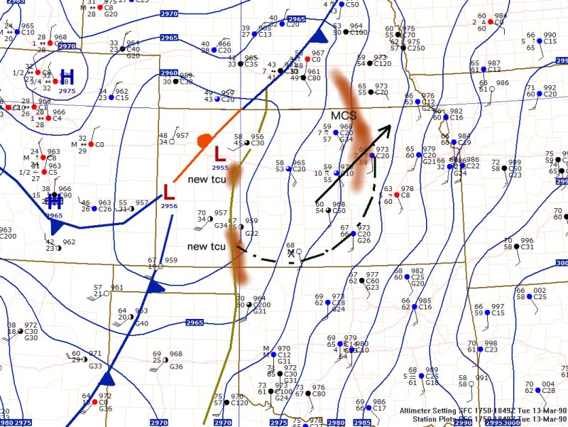
Surface low pressure began to develop in north central Kansas and it would eventually bomb out to the north days later. At the same time, a dry line was bulging northeastward through the center part of the state. The warm front was draped southwest to northeast in Nebraska and Iowa.
Temperatures into the 60s and 70s in Nebraska and Kansas were accompanied by dew points surging into the 60s on fresh south to southeast winds. An early-morning Mesoscale Convective System was long gone by early afternoon, but it left boundaries behind that would be part of the conduit for explosive supercell development.
By 3 p.m., the cork popped. Within an hour and a half the first F5 of the day was on the ground, with 56 more tornadoes to come before midnight.
One of the early tornadoes of the entire sequence, the Hesston F5 is cited as the first major tornado to be recorded on video by multiple members of the general public. Slower than today, but still pretty fast, footage of the sooty-black Hesston tornado ripping a town to shreds hit the news cycle and thrust national attention back to how dangerous significant tornadoes can be.
The “Hesston tornado” actually touched down to the southwest of Hesston, but it grew to F5 strength as it hit the town. 226 homes and 21 business were damaged or destroyed, with 30 structures totally destroyed (as in gone) and 90 wrecked beyond being fixable.
Amazingly, only two people — one in each of the F5s — died in the tornado barrage with over 80 injured 60 injuries came in the first Hesston tornado alone. The low death toll overall can be attributed to highly accurate and timely warnings from the NWS, as well as high visibility, and the fact that a large number of tornadoes did not hit population centers.
Below are two more videos that are especially compelling. One is from very close to the tornado, and another showing the first F5 getting taken over by the developing second F5.
Read/Watch More
NWS Hastings report on the outbreak
NWS Wichita report on the outbreak
Twenty Years after the Hesston Tornado
Hesston Tornado Caught On Police Dash-Cam
Hesston Kansas F5 Tornado , March 13th 1990
Hesston Kansas Tornado (1990)
Wakita, OK Mar 13 1990
Additional Sources
NOAA Central Library, U.S. Daily Weather Maps Project. http://docs.lib.noaa.gov/rescue/dwm/data_rescue_daily_weather_maps.html
NOAA Earth System Research Laboratory, “Daily Mean Composites.” http://www.esrl.noaa.gov/psd/data/composites/day/
Penn State Department of Meteorology, “e-Wall: North American Reanalysis Selection
Page.” http://www.meteo.psu.edu/~gadomski/NARR/index.html
Tornado History Project
http://www.tornadohistoryproject.com/
Get updates about U.S. Tornadoes on Twitter and Facebook.
Latest posts by Ian Livingston (see all)
- Top tornado videos of 2023 - January 1, 2024
- March 31, 2023 tornado outbreak videos - March 31, 2023
- Top tornado videos of 2022 - December 31, 2022
Ian is it true the F5 Hesston tornado was the widest tornado ever recorded at nearly 2 miles in width?
It’s listed as 1320 yards max which is about .75 miles. I believe the Hallam, NE tornado May 22, 2004 is thought to be the widest on record around 2.5 miles tho I’d have to look through the database.
Ian, I believe the tornado hit Burrton, KS in which a 6 year old died by bricks of the fireplace in the basement before hitting Hesston, KS, then moving on to Goessel, KS.