The text below was included in the Area Forecast Discussion from the Dallas/Ft. Worth National Weather Service this morning. It goes into what the storm setup looked like the morning of the outbreak, with details about how the smaller-scale features aided in tornadic supercell formation.
/April 3rd Tornado Outbreak/
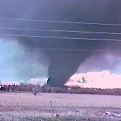
Survey teams will be heading out early to assess the damage that occurred across north texas yesterday from the tornadic supercells. Approximately 11-13 areas of damage have been reported and will be surveyed today and on thursday if needed. It is unknown at this time exactly how many tornadoes there were and the survey teams today will be working to determine a more concrete number. Information about the surveys will be disseminated throughout the day through our webpage and Facebook page as the survey teams investigate the damage. A more complete write-up will likely not be issued until late this evening.
At this time yesterday…all evidence was suggesting the event would be a fairly typical spring severe weather day across north Texas. It was anticipated that a line of severe storms would form around midday and move east across part of the region. The potential for tornadoes was discussed but it was the mesoscale features that played a significant role in what ended up being an outbreak across north Texas. It appears an outflow boundary from storms over Oklahoma early Tuesday morning ended up being a key player in enhancing the tornado threat. This outflow boundary pushed south across the red river yesterday morning and reached the interstate 20 corridor before stalling. Discrete supercells managed to form ahead of the developing line of storms. As these supercells moved north and crossed the outflow boundary…they entered an environment with increased low level shear due to easterly surface winds. It was also noted by local real time modeling that the surface to 3km cape was very high in the areas where the tornadoes occurred. A link between increased low level cape and tornadoes has been found in previous research. More in depth study and analysis will likely be done on this day in the near future. This was a good example of how small mesoscale features can quickly change the storm environment on any given day when severe weather is anticipated. Unfortunately it is still very difficult if not impossible for the models to resolve these small mesoscale features…and it is why we urge everyone to pay attention to the weather on days when severe weather is expected.
Latest posts by Mark Ellinwood (see all)
- Spring 2023 seasonal tornado outlook - March 1, 2023
- Spring 2022 seasonal tornado outlook - March 1, 2022
- Spring 2021 seasonal tornado outlook - March 1, 2021