1-3 DAY
Thursday
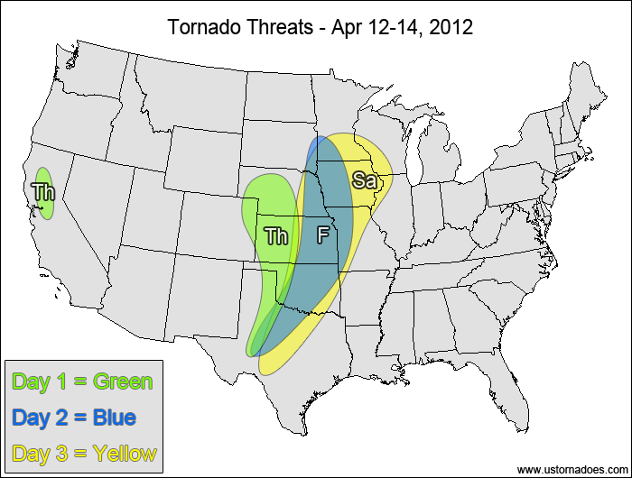
Central and southern High Plains — POTENTIAL: High — CONFIDENCE: Normal
The potential for a tornado outbreak remains in the forecast today, with the highest concentration of tornadic storms expected to be in western Kansas, western Nebraska and far eastern Colorado. Further south into Oklahoma and Texas, a moderate to strong cap will be in place and is expected to inhibit most storm formation despite moderate to high shear and moderate CAPE. Though there is a cap in place, the latest RUC model runs do show storm initiation in the OK/TX panhandles. If these southern storms can form, they will be in a more favorable atmosphere and more isolated compared to the storms in KS/NE/CO, giving them the opportunity to be stronger and produce more violent tornadoes.
California — POTENTIAL: Low — CONFIDENCE: High
Storms forming in a low CAPE, moderate/high shear environment with strong upper-level support could become tornadic during the afternoon and evening hours.
Friday
Plains, western Midwest — POTENTIAL: Medium — CONFIDENCE: Normal
Storms could struggle to form during the daylight hours in the risk area on Friday, but storms that form during the evening and overnight hours will be in an environment with moderate to high shear and low to moderate CAPE, producing a good amount of tornadic potential despite a somewhat stable boundary layer. This has some potential to be another tornado outbreak day if storms do fire during the day and if the overnight activity can get rooted to the surface. While the global models trigger some storms during the daytime hours, the hi-res models hold back on storm initiation.
Saturday
Plains, western Midwest — POTENTIAL: High — CONFIDENCE: High
A tornado outbreak is likely on Saturday, but storm initiation in the Plains could be delayed due to the slower progression of the upper-level forcing on the high-res models. Even the GFS hints at some delay in daytime storm formation, though some storms do fire during the late afternoon and early evening as height falls progress eastward more quickly compared to the hi-res models. The overnight potential is strong as the cold front progresses eastward and boundary layer stability is less of a concern. Further north in the western Midwest, moderate CAPE in conjunction with moderate to high shear will bring the tornado risk all the way into southern Minnesota and Wisconsin as the warm front lifts northward.
4-7 DAY
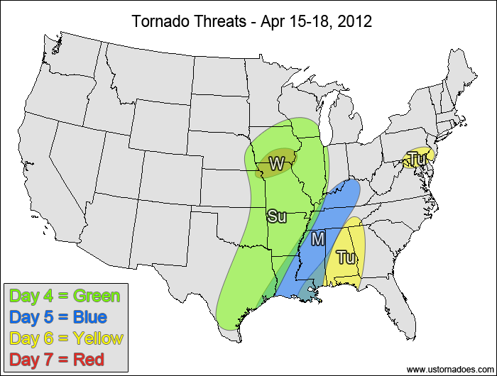
East-central Plains, ArkLaTex, Midwest — POTENTIAL: High — CONFIDENCE: Normal
Storms will continue to form along and ahead of an advancing cold front in an environment with low to moderate CAPE and moderate to high shear. Storms will become more linear in nature as the day progresses, but embedded rotation within the main line of storms and the potential for discrete cell formation ahead of the main line will keep the potential high for getting at least several tornadoes. The most strongly favored areas will be in the Midwest where the best dynamics are and in eastern Texas where the highest instability is.
Monday
Southern MS Valley, Tennessee Valley — POTENTIAL: Low — CONFIDENCE: Normal
The tornado threat diminishes going into Monday as the storm system deamplifies and accelerates eastward. Storms will become more linear in nature as low level directional shear decreases and the atmosphere transitions into more unidirectional flow. CAPE will be fairly low, with the highest amounts in the western Southeast.
Tuesday
Southeast — POTENTIAL: Very Low — CONFIDENCE: Normal
Storms that form in the Southeast will be linear in nature, but embedded supercells are not out of the question.
Mid-Atlantic — POTENTIAL: Very Low — CONFIDENCE: Low
If enough daytime heating occurs, there could be enough instability present in a moderately-sheared environment for storms to briefly become tornadic.
Wednesday
Southern Iowa, northern Missouri — POTENTIAL: Very Low — CONFIDENCE: Low
Despite a lack of low-level moisture, there will be enough upper-level dynamics associated with low CAPE and low to moderate shear to warrant a risk area.
Latest posts by Mark Ellinwood (see all)
- Spring 2023 seasonal tornado outlook - March 1, 2023
- Spring 2022 seasonal tornado outlook - March 1, 2022
- Spring 2021 seasonal tornado outlook - March 1, 2021


