1-3 DAY
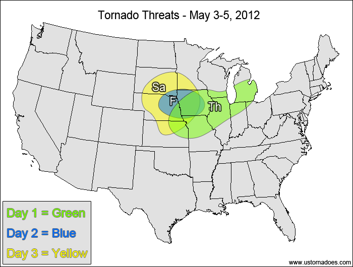
Thursday
East-central Plains, Midwest — POTENTIAL: Low — CONFIDENCE: High
Despite moderate to high instability over a wide area, the wind shear will generally be too weak and/or won’t have enough low-level rotation to support tornadic storms. The best chance for tornadic potential will be in eastern Iowa to southern Michigan, where there’s strong enough winds aloft to support tornadic storms.
Friday
Eastern Nebraska, Iowa — POTENTIAL: Low — CONFIDENCE: High
The risk area highlights the best instability/shear combination within the warm sector, as other areas with moderate to high instability have winds that are too weak to support tornadic storms and/or are backed in the upper levels.
Saturday
Northern and central Plains, west-central Midwest — POTENTIAL: High — CONFIDENCE: Normal
An upper-level trough will start to work into the northern Plains Saturday, with moderate wind speed shear and strong directional shear overlapping an area of low to moderate CAPE as height falls work across the region. The highest CAPE values are found in the southern parts of the risk area, but the shear will be weaker there. Confidence is not high due to timing differences between the models along with differences in the northern and western extent of the risk area.
4-7 DAY
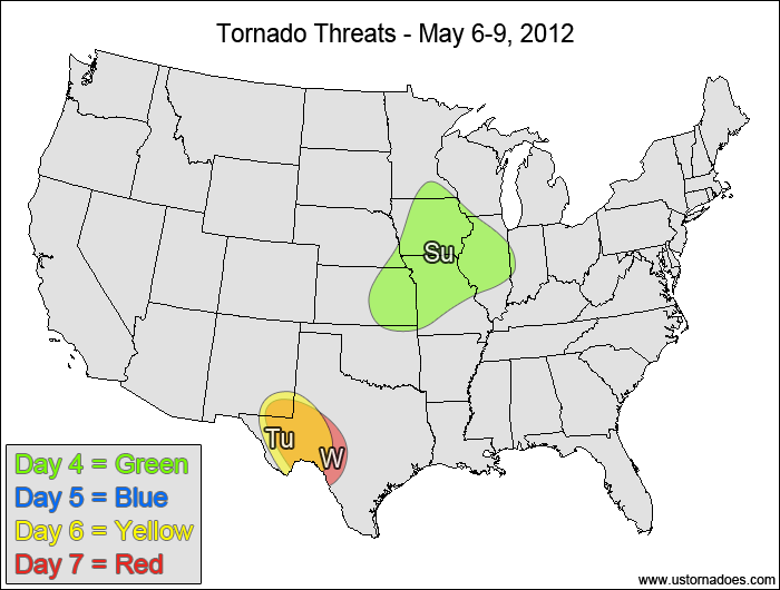
Sunday
East-central Plains, western Midwest — POTENTIAL: Medium — CONFIDENCE: Normal
The system will quickly lose it’s tornadic potential Sunday as the shear across the warm sector weakens and becomes more unidirectional. The greatest risk will be near the triple point in southern Iowa and northern Missouri.
Monday
No tornadic activity expected.
Tuesday
Southern High Plains — POTENTIAL: Medium — CONFIDENCE: Normal
A jet streak nosing into the southern High Plains will intersect the dryline, which will allow for storm formation in a moderate shear and low to moderate CAPE environment. The northern edge will be limited by a southward-advancing cold front. Low-level instability will be a concern, but there should be enough CAPE present for some tornadic development. There is good model agreement regarding the timing and location at this range, but low-level instability and capping concerns along with the fact that we will be dealing with a cut-off low in the upper levels will keep confidence limited.
Wednesday
Southern High Plains — POTENTIAL: Medium — CONFIDENCE: Low
Moderate to strong shear in combination with low to moderate CAPE ahead of a cut-off upper-level low will continue the tornadic potential in the southern High Plains. Despite good model agreement in the timing and placement of the cut-off trough, the nature of it being cut off from the main flow at this range along with the other mitigating factors listed in Tuesday’s discussion will keep confidence low.
Latest posts by Mark Ellinwood (see all)
- Spring 2023 seasonal tornado outlook - March 1, 2023
- Spring 2022 seasonal tornado outlook - March 1, 2022
- Spring 2021 seasonal tornado outlook - March 1, 2021