1-3 DAY
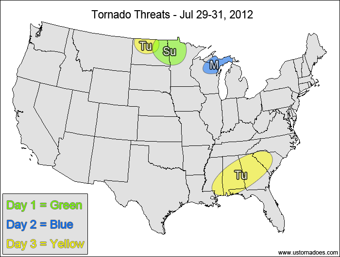
Sunday
Eastern North Dakota, northwestern Minnesota — POTENTIAL: Low — CONFIDENCE: Normal
Storms that form ahead of a short-wave trough will be in an environment with moderate CAPE and speed shear. The directional shear is excellent, but high LCLs and dry low-level air will inhibit tornado formation.
Monday
Northwestern Great Lakes — POTENTIAL: Very Low — CONFIDENCE: High
Low to moderate CAPE and shear will allow for some rotation in storms that develop, but limited directional shear in the low to mid levels and isolated storm coverage will keep the potential very low.
Tuesday
North Dakota — POTENTIAL: Very Low — CONFIDENCE: Normal
A surface low could trigger rotating storms in a low to moderate CAPE and shear environment, however high LCLs and dry low-levels will inhibit the tornado potential once again.
Southeast — POTENTIAL: Low — CONFIDENCE: Normal
Low to moderate CAPE and good directional shear will be in place across the Southeast, but weak speed shear and a lack of organized convection will keep the potential limited.
4-7 DAY
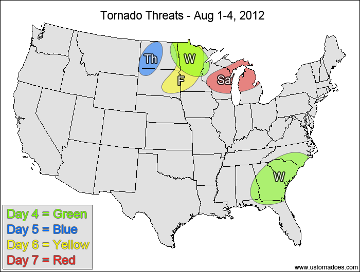
Wednesday
Northwestern Midwest — POTENTIAL: Low — CONFIDENCE: Normal
A weak disturbance moving along the U.S./Canada border will bring moderate to strong speed shear into an environment with low to moderate CAPE, but questionable directional shear and storm coverage will keep the overall potential low.
Eastern Southeast — POTENTIAL: Low — CONFIDENCE: Normal
Tuesday’s setup will continue over into Wednesday as the risk shifts slightly eastward.
Thursday
Dakotas — POTENTIAL: Very Low — CONFIDENCE: Normal
A round of storms ahead of a strengthening upper-level trough will fight against initially high LCLs, but if storms can get rooted to the surface there is the potential for a tornado.
Friday
Dakotas, Minnesota — POTENTIAL: Medium — CONFIDENCE: High
A stronger disturbance developing over south-central Canada will bring moderate shear into an environment with moderate CAPE, allowing for some tornado potential ahead of the system’s cold front.
Saturday
Great Lakes — POTENTIAL: Low — CONFIDENCE: Normal
A similar setup to Friday will advance into the Great Lakes, with weaker directional shear lowering the overall potential.
Latest posts by Mark Ellinwood (see all)
- Spring 2023 seasonal tornado outlook - March 1, 2023
- Spring 2022 seasonal tornado outlook - March 1, 2022
- Spring 2021 seasonal tornado outlook - March 1, 2021