When looking at the models the afternoon of December 9th, and even early the morning of December 10th, conditions did not seem overly favorable for a tornado outbreak in the Southeast. As noted by the SPC discussion from the morning of the outbreak, the threat was fairly conditional and would perhaps yield a tornado or two:
ALTHOUGH THE STRONGEST FORCING FOR ASCENT ASSOCIATED WITH THE
AFOREMENTIONED SHORTWAVE TROUGH IS FORECAST TO MOVE WELL N OF THE
WARM SECTOR…TSTM DEVELOPMENT SHOULD PERSIST THROUGH THIS AFTERNOON
FROM SRN LA NEWD INTO THE SRN APPALACHIANS ALONG/AHEAD OF THE EWD
MOVING COLD FRONT. MORNING SFC OBS SHOW MOISTURE WITHIN THE WARM
SECTOR IS CHARACTERIZED BY DEWPOINTS IN THE UPPER 60S ALONG THE GULF
COAST TO UPPER 50S-LOWER 60S ACROSS NRN AL/GA. HOWEVER…WIDESPREAD
CLOUD COVER AND MODEST MIDLEVEL LAPSE RATES WILL LIMIT
INSTABILITY…WITH OBSERVED AND FORECAST MODEL SOUNDINGS SUGGESTING
MLCAPE VALUES WILL RANGE FROM NEAR 300 J/KG ACROSS NRN AL TO OVER
800 J/KG IN SRN LA. NEVERTHELESS…BOTH DEEP-LAYER AND LOW-LEVEL
SHEAR WILL BE SUFFICIENT /E.G. 25-35 KTS OF 0-1 KM AGL SHEAR/ FOR A
THREAT FOR ISOLATED DMGG WIND GUSTS AND PERHAPS A TORNADO OR
TWO…PARTICULARLY THROUGH THE LATE MORNING HOURS.
Normally in these kind of setups, where the wave is deamplifying and the surface low and upper-level vort. max are well to the north, a tornado or two is what one would expect.
Despite strong shear aloft, winds at the surface are generally out of the southwest ahead of the cold front with these setups, creating fairly unidirectional flow that would not be that favorable for tornadic development. In the case of December 10th, surface winds had more of a southerly component, which helped induce rotation in the low levels of the atmosphere. In addition to this added rotation, other parameters like low-level bulk shear and instability were under-forecast, which led to an environment that was more suitable for tornadoes than originally anticipated.
Below is a comparison of some of the variables. On the left is the 30 hour forecast from the 12z NAM the day prior, which is valid for 18z on the 10th. On the right is the 18z NAM initialized values for the 10th. As you can see, some of the key parameters for tornado formation were under-forecast:

The result was a tornado outbreak in a region that had not seen tornadoes since October 17th. As of this writing, it appears that there were 7 tornadoes during the event (subject to change).
December tornado outbreaks are not all that uncommon. Since 1950, tornado outbreaks (defined here as days with 6+ tornadoes) have occurred a little less than once a year, with a total count of 57 outbreaks in 62 years (data provided by Ian):

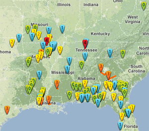
NWS warnings issued on the 10th:

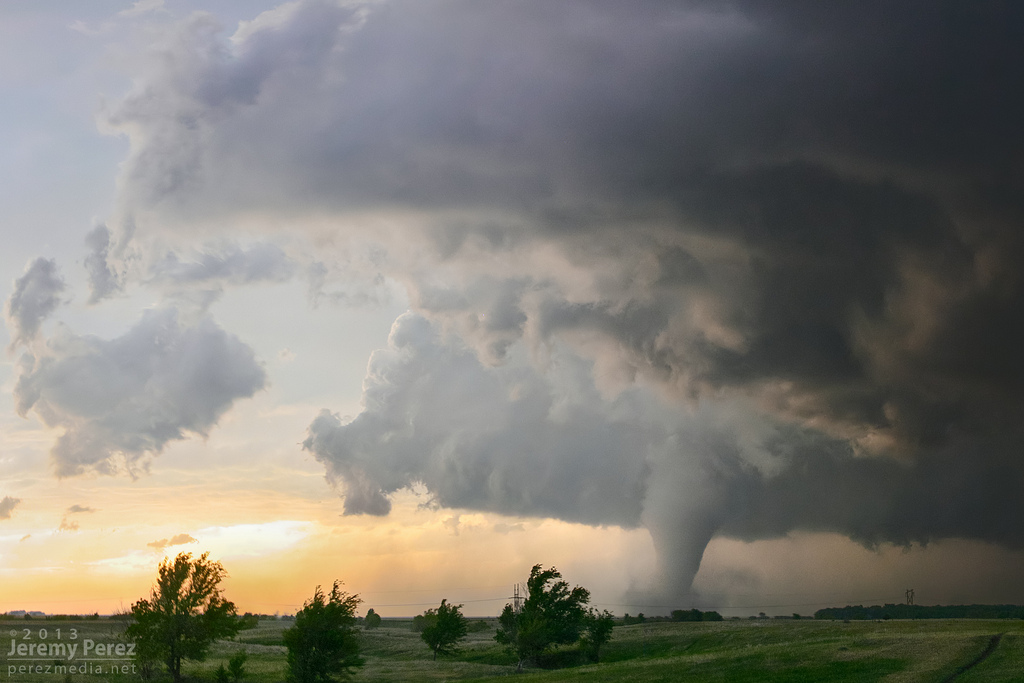
A handful of pictures and videos came out of the outbreak, including this video of a wedge tornado (preliminarily rated EF-1) in Florida:
Latest posts by Mark Ellinwood (see all)
- Spring 2023 seasonal tornado outlook - March 1, 2023
- Spring 2022 seasonal tornado outlook - March 1, 2022
- Spring 2021 seasonal tornado outlook - March 1, 2021