A potent cut-off low will bring the risk for tornadoes to the western Gulf Coast late tomorrow into Wednesday. Wind shear will be favorable for rotation, but there are some limiting factors. Typically, cut-off lows aren’t prolific tornado producers, as the upper-level winds have more of a southerly component that limits the directional shear. With this system, the surface winds have a more easterly component than usual, which will produce a nice veering wind profile over the warm sector despite the more southerly component of the winds aloft. Each day has the potential for one or two tornadoes, but risks are more to the low side as things could go more wrong than right.
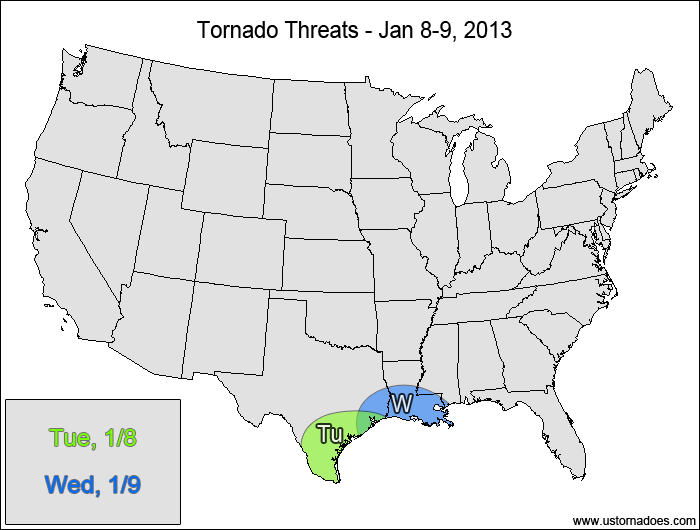
Southern Texas — POTENTIAL: Medium — CONFIDENCE: Normal
A mid-level temperature inversion will act as a cap on the atmosphere throughout the day, limiting surface-based storm formation in the warm sector. The storms that do form will be elevated and will mostly likely not be tornadic. Overnight, height falls associated with a cold front will make their way into the unstable air, allowing for the development of a squall line that could produce tornadoes. Some discrete supercells capable of producing tornadoes may pop up ahead of this main line. One other concern that could limit tornado potential is the possibility of backing winds in the upper-levels, which is shown on the GFS but not the NAM.
Southeastern Texas, southern Louisiana — POTENTIAL: Medium — CONFIDENCE: Normal
The setup won’t be too dissimilar to Tuesday night as the tornado threat pushes eastward with the disturbance. The main threat will continue to be embedded rotations within the squall line as it pushes eastward, with a chance for pre-frontal supercells. Instability looks to be lower/more compromised compared to Tuesday as the warm sector becomes more saturated, which will limit the lapse rates and updraft speeds.
Latest posts by Mark Ellinwood (see all)
- Spring 2023 seasonal tornado outlook - March 1, 2023
- Spring 2022 seasonal tornado outlook - March 1, 2022
- Spring 2021 seasonal tornado outlook - March 1, 2021