With meteorological spring starting on March 1st, it is time to take a look at the months ahead to see how active the spring tornado season may be. Are the pattern changes we have seen in recent weeks a sign of things to come for March through May, or just a sizable blip on the radar?
The Plains has been somewhat active with winter storms in recent weeks, which is a notable change to what we saw in December and January. A sudden stratospheric warming event and an uptick in tropical activity that is commonly tracked using the Madden-Julian Oscillation (MJO) broke down the persistent cool western U.S./warm eastern U.S. pattern that we went through most of December and January.
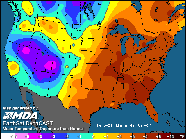
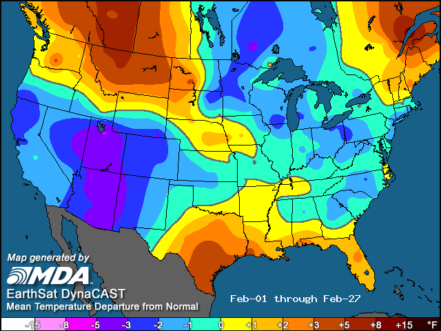
(Temperature maps via MDA Weather Services/EarthSat)
Does the February pattern change mean anything for the future? While late winter pattern changes sometimes provide a glimpse of what we can expect in spring, it does not appear that this will be the case this year through the entire season.
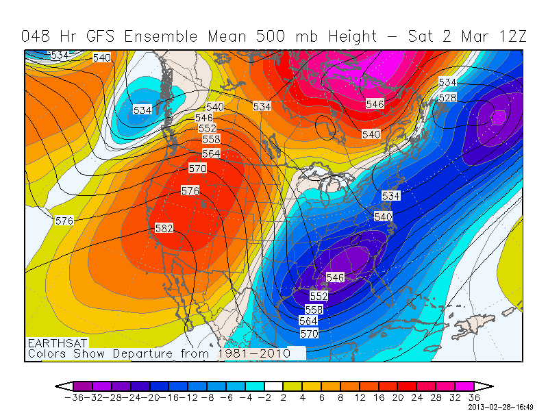
The first week to ten days of March certainly will not come in strong as far as tornadoes are concerned as an upper-level ridge sets up over the western U.S. and an upper-level trough digs into the eastern U.S. This creates northwesterly/northerly flow over the Plains and basically cuts off Gulf moisture from getting drawn up into the U.S.
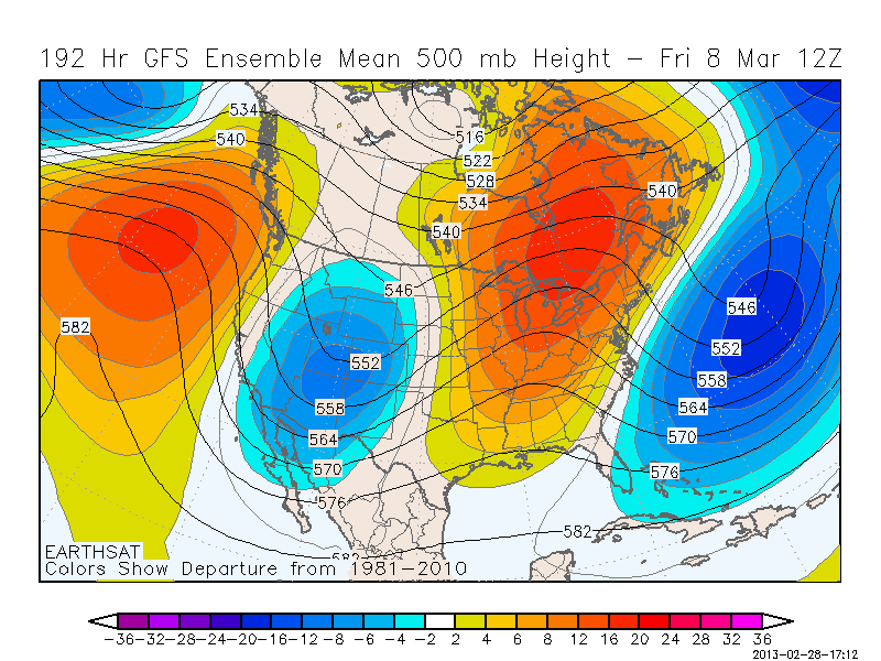
Once we get past the first week of March, this pattern starts to break down and becomes more variable. It’s still not ideal for tornadic systems, but definitely a step in the right direction.
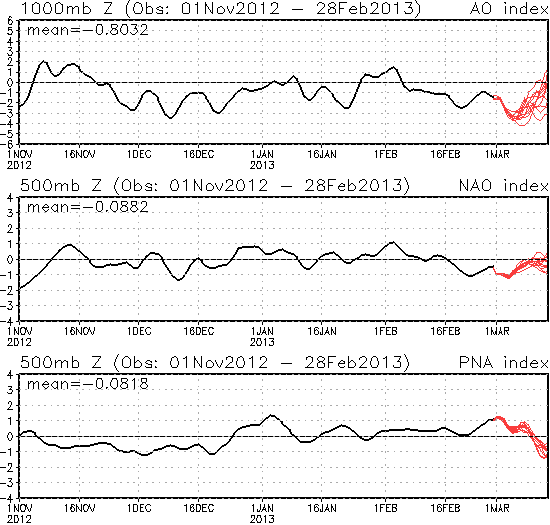
Beyond that, the different teleconnections used in medium-range forecasting (AO, NAO, PNA) start to trend in a way that could allow for above normal tornadic activity as we get into the middle to later part of March, possibly extending into April.
3/15 update for 2nd half of March: Will the second half of March be quiet as well?
Heading into the back half of spring, more long-term signals are needed to help determine the likelihood of an active or inactive season. Two major long-range signals for the U.S. are the Pacific Decadal Oscillation (PDO) and the Atlantic Multidecadal Oscillation (AMO).
The PDO measures sea surface temperatures over the Pacific Ocean. The PDO remains in its negative phase, and this phase promotes troughing (and cooler temperatures) over the western U.S. as well as ridging (warmer temperatures) over the central and eastern U.S. The negative PDO is a huge reason as to why the eastern half to two-thirds of the U.S. has been so warm in recent years.
The other major factor is the AMO, which has been running mostly in the positive range for a number of years. A positive AMO also correlates to warmer than normal temperatures over most of the U.S. These two primary signals are fairly useful due to their longevity (generally staying the same sign for roughly 15 years).
Additional signals include the El Niño-Southern Oscillation (ENSO) and soil moisture.
The ENSO signal has been fairly weak in recent months, remains forecast to be weak, and has not been a major driver of the pattern. For that reason, I do not factor the ENSO phase into my outlook at this time. Soil moisture, while gaining some relief in recent weeks, still remains a major issue across the central U.S.
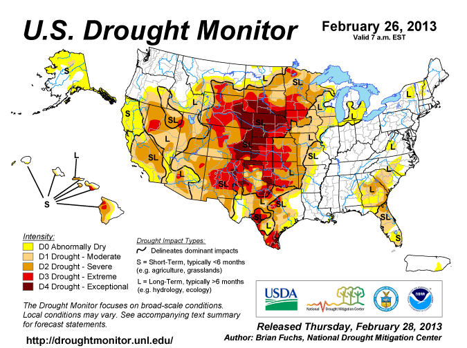
Such widespread drought often persists on a multi-year scale, and since some areas remain under a severe drought. It is not likely to end anytime soon. The Climate Prediction Center’s forecast keeps a persistent drought over most of the central and southwestern U.S. through spring. The drought will likely lead to warmer and drier conditions over a large portion of the central U.S. as we get into the back half of spring, which does not bode well for an exceptionally active peak tornado season (May and June).
Bottom line…
Putting all of these factors together, I would expect a near average tornado season this spring (March through May), with a somewhat active early season before the longer term signals trend towards a quieter (compared to normal) back half of spring. The warmer and drier conditions induced by the -PDO/+AMO/drought combo over the central U.S. could cut down on the tornado potential during the back half of spring and probably the summer months as well.
This is a low confidence forecast due to the uncertainty in pattern trends.
Long term forecasts, while generally providing added value to climatology, are still very broad-brush outlooks and do not offer a very consistent level of skill. This forecast only hopes to capture some of the most reliable information available to provide a best guess as to what spring may bring.
Latest posts by Mark Ellinwood (see all)
- Spring 2023 seasonal tornado outlook - March 1, 2023
- Spring 2022 seasonal tornado outlook - March 1, 2022
- Spring 2021 seasonal tornado outlook - March 1, 2021
Great write up!
This actually help a lot of confusion I had about both PDO and AMO related to conditions for tornadoes.
Thanks!
Michael C.