A winter storm will bring the potential for tornadoes to the southeastern U.S. over the next few days, with the greatest risk for tornadoes stretching from southern LA to southern GA and northern FL Saturday night.
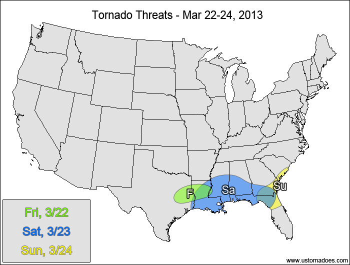
Friday
East-central TX, northern LA — POTENTIAL: Low — CONFIDENCE: Normal
A mid-level cap will be in place across the threat area for most of the afternoon that will limit convection initially, but as this cap gets eroded in the late afternoon and evening hours, storms are expected to pop up over eastern Texas and Louisiana. Shear will be favorable for rotation, with high surface dewpoints and steep lapse rates above the cap allowing for moderate levels of CAPE in the 1500-2500 J/kg range. Despite somewhat favorable atmosphere, there will not be much forcing to help initiate and organize storms, which will keep the tornado potential limited.
Saturday
Gulf Coast — POTENTIAL: High — CONFIDENCE: Normal
Isolated storms will pop up during the afternoon hours along the Gulf Coast, with the northern extent tornado threat limited as the warm front stays fairly close to the Gulf Coast, and the elevated storms north of the warm front will struggle to produce tornadoes.. As the surface low develops over the western Southeast during the evening and overnight hours, the warm front and tornado threat will expand northward and storm coverage will increase. Several tornadoes are possible as the system gets its act together late Saturday.
Sunday
Eastern Southeast — POTENTIAL: Low — CONFIDENCE: Normal
The tornado threat will continue into Sunday as the system works its way east. While directional shear decreases, speed shear will increase and there will be enough instability to support a low tornado threat.
Latest posts by Mark Ellinwood (see all)
- Spring 2023 seasonal tornado outlook - March 1, 2023
- Spring 2022 seasonal tornado outlook - March 1, 2022
- Spring 2021 seasonal tornado outlook - March 1, 2021
Gonna go ahead and add this one to the bust pile.