The main tornado threat will be Wednesday and Thursday across the southern Plains and the central and southern Mississippi Valley, with mixed risks to the possible number of tornadoes.
1-3 DAY
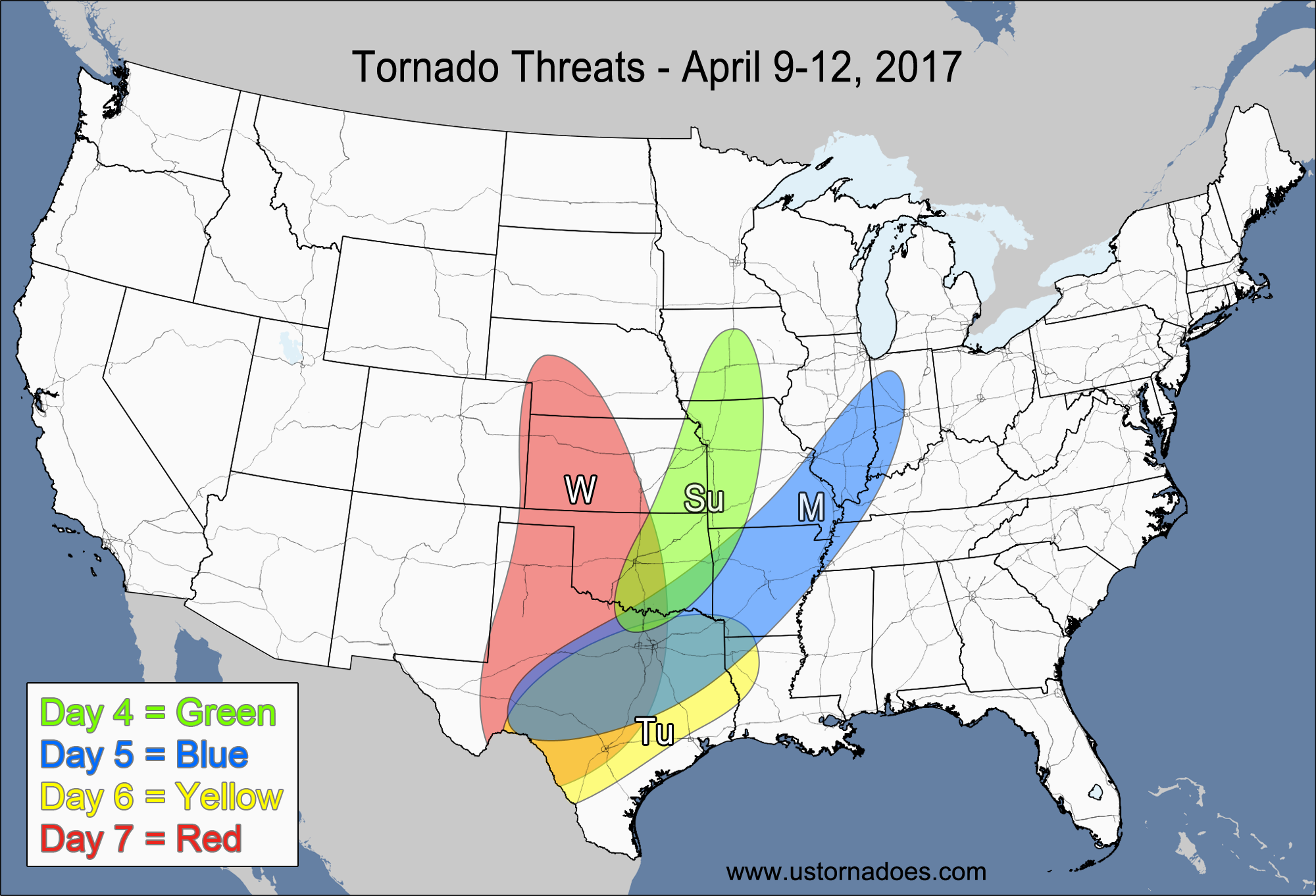
Monday
Southeastern Plains, northern AR, southern MO — POTENTIAL: Low — CONFIDENCE: Normal
Some storms are expected to fire near a stationary front in an environment with moderate instability and enough shear for any supercells to possibly produce a tornado or two. High LCLs and a weak cap are expected to inhibit tornadic activity.
Tuesday
North-central Texas, southwestern Oklahoma — POTENTIAL: Very Low — CONFIDENCE: Normal
Moderate to high instability and favorable directional shear raise some concern for a tornado along the dryline on Tuesday, but high LCLs and no real upper-level forcing should severely limit storm coverage.
Kentucky, Tennessee — POTENTIAL: Very Low — CONFIDENCE: Normal
Storms are expected to fire along/ahead of a weakening frontal boundary in an environment with low to moderate CAPE and decent/good directional shear, but relatively weak winds aloft should keep the tornado potential limited.
Wednesday
Southern Plains, southern Midwest — POTENTIAL: Medium — CONFIDENCE: Low
Lots of discrepancies between the models can be found regarding front placement and storm coverage in the warm sector, which will drop forecast confidence as the main storm system starts to take shape. Depending on the storm evolution, there are risks to both the upside and downside. GFS is a northern outlier as surface low development over western Kansas allows for a more expansive warm sector that provides additional risk north of the highlighted risk area above. The ECMWF and NAM suggest a vastly different solution for this range, with the surface low in the Texas Panhandle and most of the precipitation north of the warm front where no tornado risk is present. This forecast favors the ECMWF/NAM solution at this time. The upper-level forcing is expected to be too far west during the daytime hours to produce much warm sector convection. Storms that do fire in the warm sector will have very favorable conditions in the southern Plains for tornado development. While not the favored solution at this time, if the greater warm sector storm coverage verifies there is the possibility of a tornado outbreak. Further east in the southern Midwest, a low risk for tornadoes is present as storms form in a low to moderate CAPE and low speed shear environment. Height rises will work against storm development in the southern Midwest.
4-7 DAY
Thursday
Western Southeast, southern Midwest — POTENTIAL: High — CONFIDENCE: Low
The upper-level forcing will become better coupled with the instability on Thursday as the system organizes and pushes eastward. The main threat will be embedded supercells along a squall line that develops along the advancing cold front. Some pre-frontal convection, cloud cover and lower instability in the 500-1500 J/kg range along with possible capping will limit the storm strength of anything that forms ahead of the main line. Strengthening speed shear will help form and organize storms near the front. The formation of a secondary low in the southwestern Midwest should help back winds at the surface and could enhance tornado potential in that region. Like Wednesday, there are risks to both the upside and downside regarding the number of tornadoes, though it seems like several tornadoes are still possible/likely given the widespread storm coverage.
Friday
Mid-Atlantic, eastern Southeast — POTENTIAL: Low — CONFIDENCE: Normal
A low CAPE/high shear environment is expected on Friday as the storm system works into the eastern U.S. Overall potential will be limited thanks to weak lapse rates, low instability and pre-frontal cloud cover. Strong speed shear and surface winds out of the south will provide enough rotation that a tornado or two will be possible despite the low instability. As of now, the greatest potential remains along the cold front with embedded supercells.
Saturday
No tornadic activity is expected.
Sunday
No tornadic activity is expected.
Latest posts by Mark Ellinwood (see all)
- Spring 2023 seasonal tornado outlook - March 1, 2023
- Spring 2022 seasonal tornado outlook - March 1, 2022
- Spring 2021 seasonal tornado outlook - March 1, 2021
How bad is this going to be for Dallas Fort Worth on Wednesday/Thursday?
Hard to give specific details yet other than what’s above. Might start to get a better idea tomorrow for Wed which probably has the most potential for that area. Check with local sources as needed!
It looks like this will not bother us until Wednesday Night. Does this mean that our tornado threat is going to be low?
That is bad enough they don’t need any more tornadoes
I don’t know how bad it is going to for Dallas fort