Tornadoes will threaten the South today and tomorrow as a high shear, low instability environment develops over the region. The environment for tornadoes will be fairly conditional, but with the strong shear, some upside risks are in play for areas that might get greater daytime heating, but the chances of that happening are low.
Just a reminder that for 2014, we have changed up the forecast format a bit, and the details can be found in our forecast from last week.
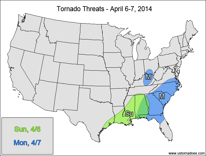
Sunday
Western and central Gulf — TORNADO RANGE: 2-7 — CONFIDENCE: Normal
Expected Tornado Hotspot: Southern Louisiana, southern Mississippi
Pros: Strong speed shear, good directional shear, good upper-level forcing, height falls moving in late
Cons: Low instability, okay/poor lapse rates, widespread cloud cover minimizing any chances for pockets of greater instability, greatest potential appears to be in the overnight hours
Monday
Eastern Southeast — TORNADO RANGE: 2-6 — CONFIDENCE: Normal
Expected Tornado Hotspot: None
Pros: Strong speed shear, decent/good directional shear, strong low-level jet to pull in higher dewpoints
Cons: Low instability, widespread clouds and rain ahead of the main threat keeping the upside potential minimized, low-topped storms
Eastern Kentucky, southern Ohio — TORNADO RANGE: 0-1 — CONFIDENCE: High
Expected Tornado Hotspot: None
Pros: Strong upper-level forcing, strong speed shear
Cons: Low instability, low directional shear
Latest posts by Mark Ellinwood (see all)
- Spring 2023 seasonal tornado outlook - March 1, 2023
- Spring 2022 seasonal tornado outlook - March 1, 2022
- Spring 2021 seasonal tornado outlook - March 1, 2021
One thought on “Tornado Threat Forecast: April 6-7, 2014”