Like hundreds of others, we set off for our annual Plains chasecation on May 16 and returned a few days ago — thus the lack of “Tornado Digests” in recent weeks. Despite a pattern which proved more active for storms than what was seen for most of 2014, tornadoes were few and far between by May standards.
Following a sizeable but local tornado event in the central Plains the second full week of the month, the final two weeks of May were heavily influenced by a slow moving upper-level cutoff low that sent waves around it pretty much daily. As the month came to a close, nearly daily threats for storms continued but only with isolated tornadoes.
Signs point to an active start to June, but it’s yet to be determined whether it will be well known for tornado production or other severe weather threats like straight line winds.
May 11-17: Central Plains and Ohio Valley
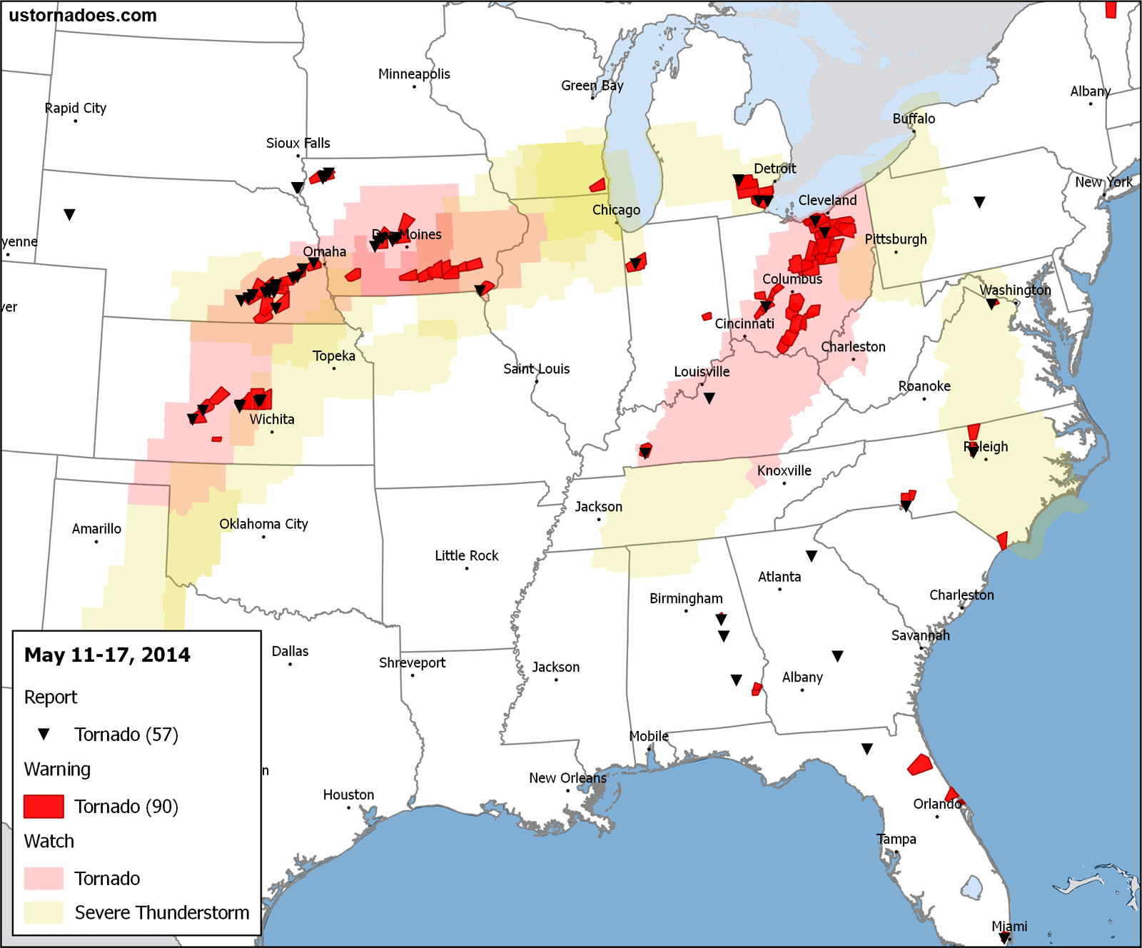
The event of the week occurred on the 11th as supercells broke out near the triple point in Nebraska as well as surrounding areas like Kansas and Iowa. As an example, NWS Omaha documented several tornadoes, including an EF-3 associated with the May 11 event.
Tornado catch earlier near Sutton, NE pic.twitter.com/sqlhmVK3DJ
— Jesse Risley (@Jesse_Risley) May 12, 2014
Tornado on the ground just south of McPherson, KS (10:00pm) #kswx pic.twitter.com/d3d5ps7SVc
— Corey Inmon (@CoreyInmon) May 12, 2014
Tornadoes continued east and south in the days ahead, and most were weak. However, another EF-3 touched down on the 14th in Ohio.
Another pic of the Cedarville, Ohio tornado (via Greg Ferguson) pic.twitter.com/MbaUtf7ZmX
— 28storms.com (@28storms) May 14, 2014
May 18-24: High Plains and Northeast
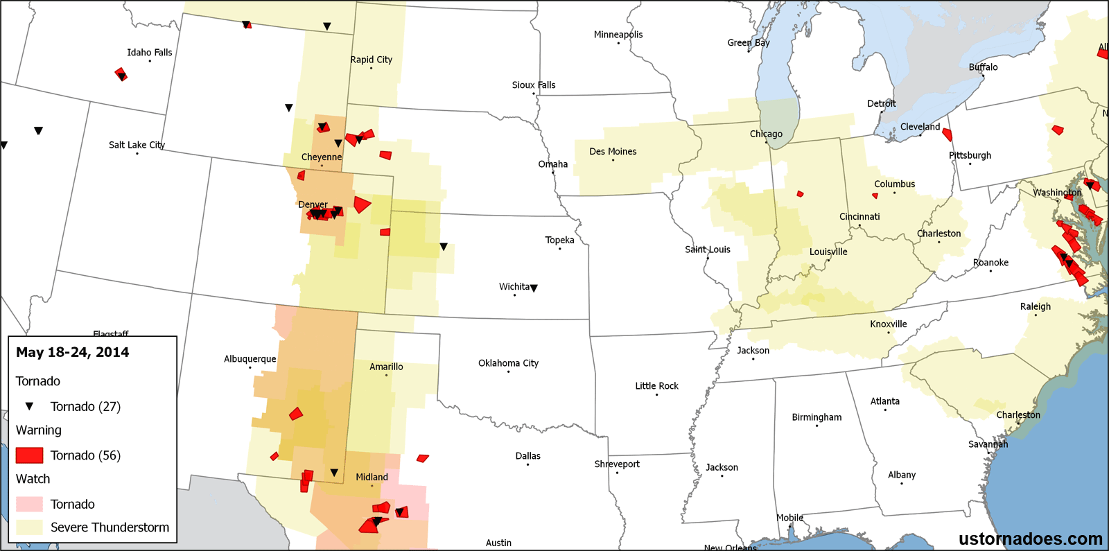
May 18 through 24 looked a bit more like summer than May overall as severe weather setups were focused near the front range and parts of the northeast. While the pattern was more active than it has been on a day-to-day basis, including tornadoes around Denver on May 21, most days were missing something when it came to getting numerous tornadoes. As we can attest to on our chasecation, many instances featured too high of temperature/dew point spreads (leading to high bases) and a frequent lack of adequate low level shear.
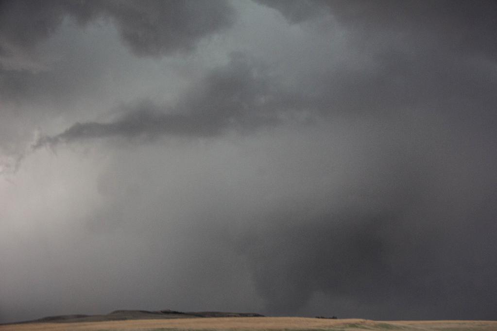
A good place to hang out throughout the period might have been the high country, as these two phenomenal shots from Wyoming show:
Tornado on Casper Mountain, Wyoming this afternoon via LightAlive photo @NWSRiverton pic.twitter.com/4LhMTfgDzd
— BuzzFeed Storm (@BuzzFeedStorm) May 23, 2014
WOW insane photo of the #tornado yesterday near Wheatland, WY from Light Alive Photography via Landon Brown. pic.twitter.com/Ob79pEPyfb
— Reed Timmer (@reedtimmerTVN) May 22, 2014
On May 22, severe weather erupted across the northeast as a number of supercells developed under northwest flow aloft. A powerful — and somewhat unusual for the region — EF-3 hit parts of New York near Albany. Other tornadoes were reported in the Mid-Atlantic as well.
Related: Upstate New York Supercell Through Dual-Pol Radar
UPDATE: NWS: Strong EF-3 #tornado hit parts of Schenectady & Albany counties #NY Thursday http://t.co/DHC2etUK8d pic.twitter.com/SU5cCEuCtE
— Johnny Kelly (@stormchaser4850) May 23, 2014
May 25-31: North Dakota and the South
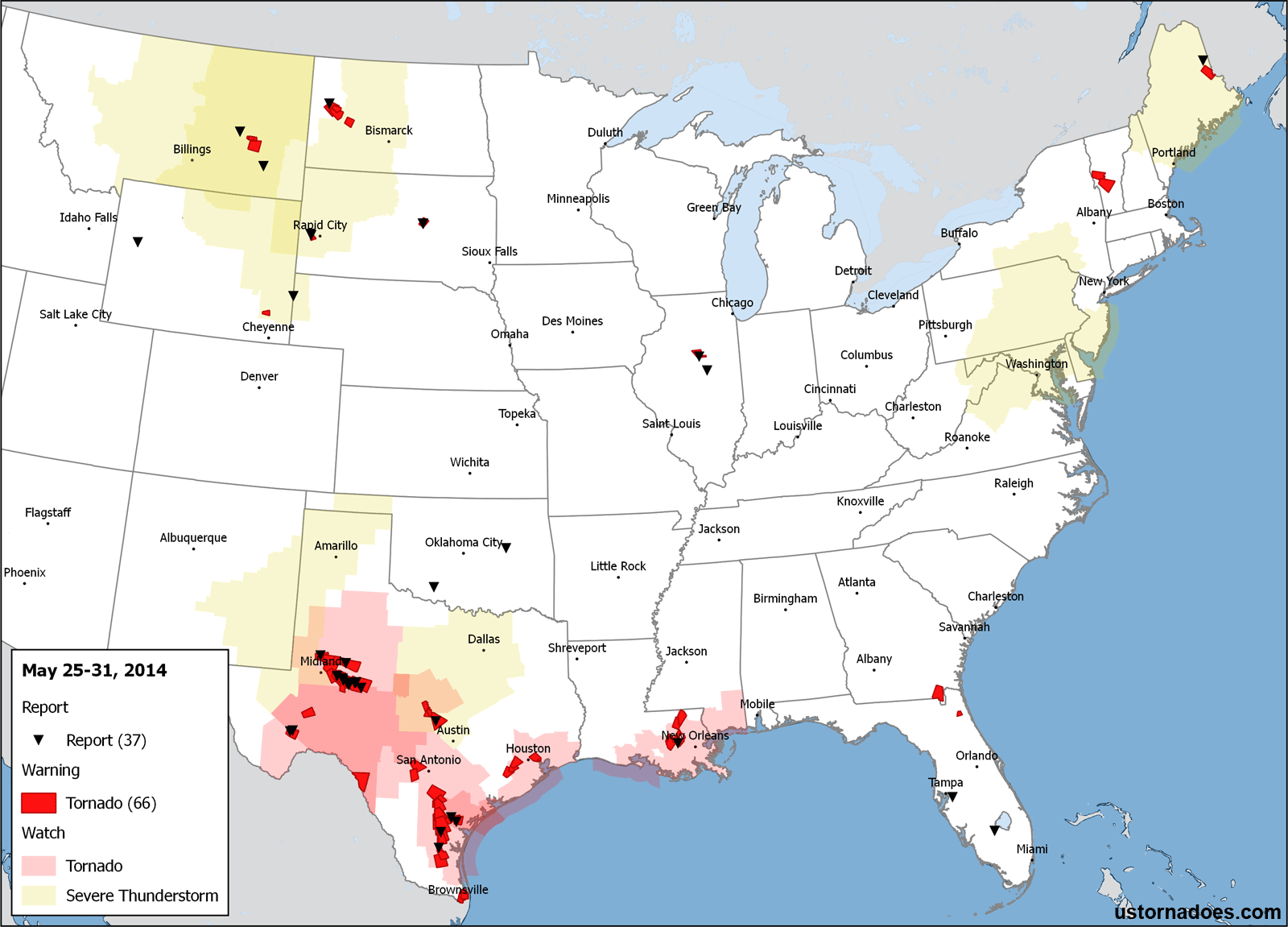
Tornado activity was consistent day-by-day yet not terribly intense for the end of May. Arguably, the event of the final week occurred on Memorial Day (May 26) as a strong tornado impacted an oil camp in North Dakota.
Caution: Strong language
On the same day down in Texas, the biggest in numbers event of the week also occurred, down along the southern part of the split jet stream thanks to the slow-moving upper low finally pushing out into the Plains. Most or all tornadoes spawned by the southern system were brief and weak during the period.
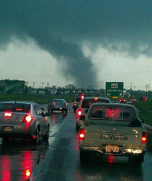
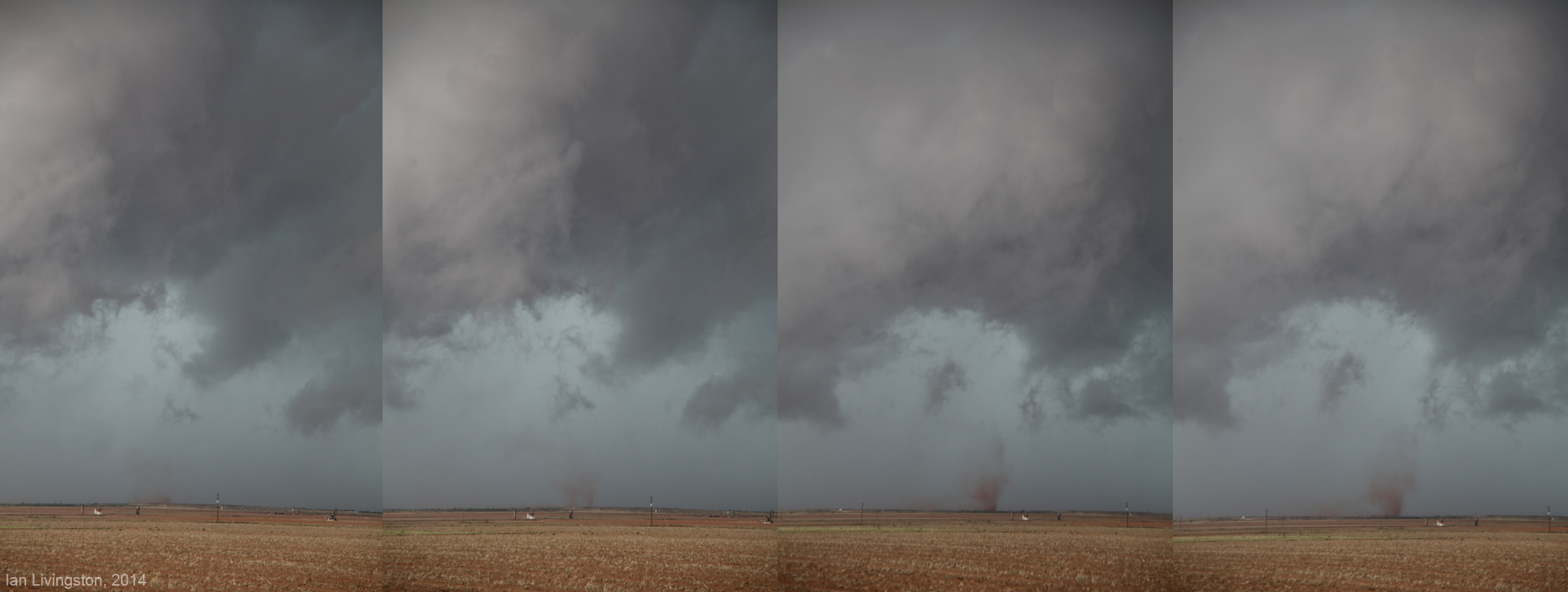
As has been the case for much of 2014 when it comes to Plains tornadoes, a big question on many minds was “is that a tornado?” The question hit us on May 26 near Lenorah, in southwest Texas. I believe the below to be a quick tornado as it occurred under a rotating wall cloud, but the final verdict is still out:
After a quiet meteorological spring, will June perform?
Though March-May were not void of larger tornadoes, the overall count was well below normal — something we alluded to as likely back at the end of February. May didn’t do a lot to add to the overall numbers, and we’re now about to get on our way out of the peak of the season.
However, June is the second highest producing month in the overall record and has proven very tornado fertile on a number of occasions.
All eyes now shift to Tuesday as a volatile air mass seems likely to form across the central Plains:
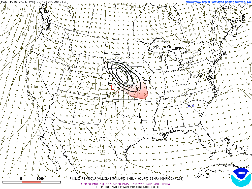
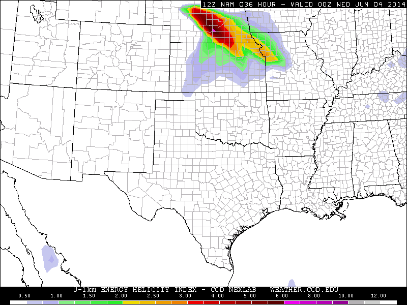
There are plenty of questions as to the evolution, and the day may end up remembered more of a damaging wind threat than anything (ultimately a derecho?). However, should it come together right, there’s a pretty high tornado intensity ceiling near the warm front.
Beyond that, there are signs a more active pattern may continue as waves of energy pass through the country over top ample moisture.
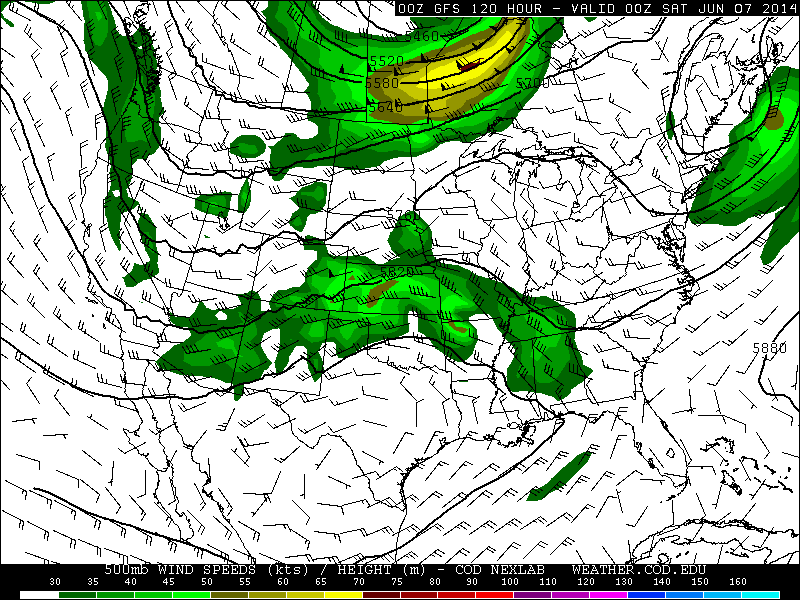
Of course, the deeper we get into June the more we need to watch for a summertime pattern of increased increased ridging over the central U.S. to possibly quickly kick in. It doesn’t appear coming in the next 7-10 days at the least.
Latest posts by Ian Livingston (see all)
- Top tornado videos of 2023 - January 1, 2024
- March 31, 2023 tornado outbreak videos - March 31, 2023
- Top tornado videos of 2022 - December 31, 2022