Climatologically-favored areas edition. Lots of threats on the High Plains and up in the northern Plains and northwestern Midwest in the coming week.
Programming Note: Starting next week, I will have a new job that involves rotating shifts, so consistent mid to late afternoon posts may be hard to come by going forward. Just going to have to go with the flow!
1-3 Day
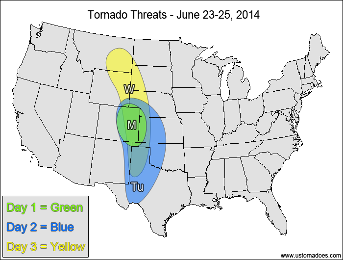
Monday
Central High Plains — TORNADO RANGE: 1-3 — CONFIDENCE: Normal
Expected Tornado Hotspot: None
Pros: Strong directional shear, decent/good speed shear, low to moderate instability
Cons: Lack of upper-level forcing, questionable storm mode, somewhat-weak low-level speed shear
Tuesday
Central and southern Plains — TORNADO RANGE: 2-7 — CONFIDENCE: Normal
Expected Tornado Hotspot: None
Pros: Good/strong directional shear, decent speed shear aloft, moderate instability
Cons: Weak upper-level forcing, somewhat-weak low-level speed shear
Wednesday
High Plains — TORNADO RANGE: 2-6 — CONFIDENCE: Normal
Expected Tornado Hotspot: None
Pros: Good/strong directional shear
Cons: High LCLs, fairly weak speed shear in the mid-levels, still no appreciable upper-level forcing
4-7 Day
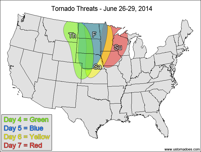
Thursday
Northern and central Plains — TORNADO RANGE: 1-5 — CONFIDENCE: Normal
Expected Tornado Hotspot: Northern High Plains
Pros: Moderate to high instability, good/strong directional shear
Cons: Weak low/mid-level speed shear, upper-level forcing still too displaced to the west to have much of an impact, high LCLs in most areas
Friday
Northern and central Plains — TORNADO RANGE: 2-6 — CONFIDENCE: Low
Expected Tornado Hotspot: Dakotas
Pros: High instability, decent/good directional shear, 500mb trough starting to work into the target area
Cons: Capping concerns in the southern areas, some speed shear concerns remain, some areas might have backing winds in the mid to upper-levels
Saturday
Northern and central Plains, northwestern Midwest — TORNADO RANGE: 2-6 — CONFIDENCE: Low
Expected Tornado Hotspot: None
Pros: Moderate to high instability, decent upper-level forcing
Cons: More unidirectional flow aloft, capping concerns in the warm sector, storm mode concerns as cold front advances
Sunday
Northwestern Midwest — TORNADO RANGE: 0-4 — CONFIDENCE: Low
Expected Tornado Hotspot: None
Pros: Moderate to high instability, decent/good speed shear, decent/good upper-level forcing
Cons: Weak/decent directional shear, questionable storm mode, advancing cold front, surface low displaced well to the north
Latest posts by Mark Ellinwood (see all)
- Spring 2023 seasonal tornado outlook - March 1, 2023
- Spring 2022 seasonal tornado outlook - March 1, 2022
- Spring 2021 seasonal tornado outlook - March 1, 2021