Early action looks to be over the north-central U.S., but we’ll at least start on a fairly quiet note today and tomorrow. Better shear in place for this weekend, but we’ll have to see how many supercells can get cranking within the more favorable setup.
REMINDER: Starting next week, I will have a new job and a new schedule. I’ll try to get the forecasts out in the mornings Monday and Thursday next week, then I will have to see what my schedule looks like after that for future updates.
1-3 Day
Thursday
Northwestern Plains, central High Plains — TORNADO RANGE: 1-4 — CONFIDENCE: Normal
Expected Tornado Hotspot: Northern High Plains
Pros: Moderate to high instability, good/strong directional shear, decent speed shear
Cons: High LCLs, storm coverage concerns in the southern areas, possible slight backing in the upper-levels across the southern areas
Friday
Northern and central Plains — TORNADO RANGE: 0-2 — CONFIDENCE: Normal
Expected Tornado Hotspot: None
Pros: Moderate instability, decent/good speed shear, decent directional shear in the low-levels, some upper-level forcing
Cons: Capping concerns, notably-backed winds in the upper-levels across most of the risk area
Saturday
Northeast and central Plains, western Midwest — TORNADO RANGE: 2-6 — CONFIDENCE: Normal
Expected Tornado Hotspot: None
Pros: Decent/good speed and directional shear, moderate instability, decent upper-level forcing
Cons: Some capping and upper-level backing concerns in the northern areas, potential ongoing cloud cover and rain in the morning and afternoon could inhibit instability, questionable storm modes for most of the risk area
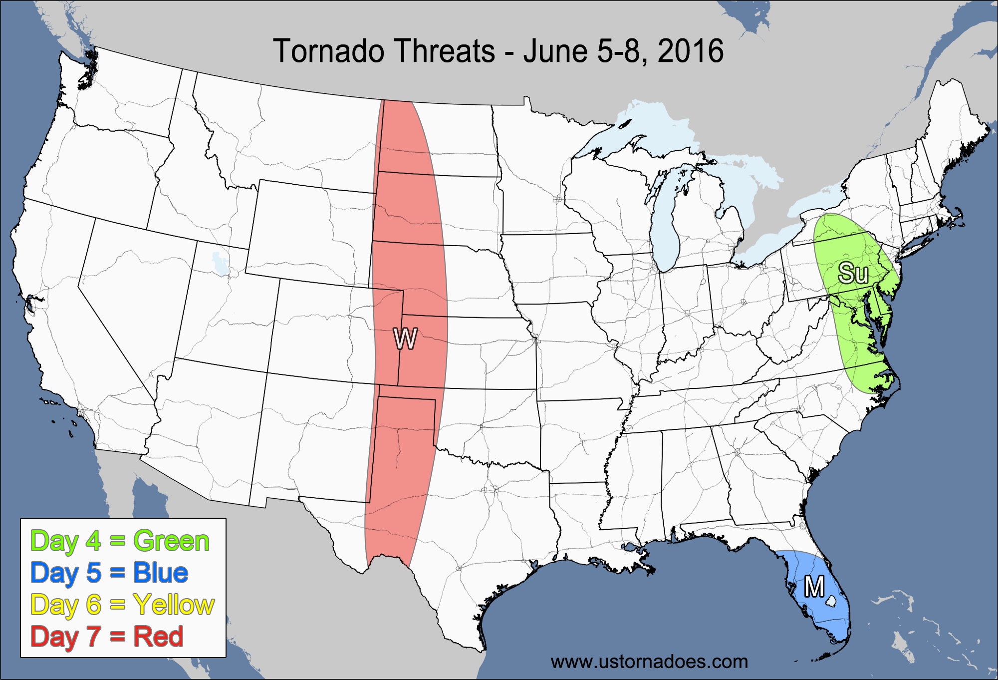
4-7 Day
Sunday
Northern Midwest, central Plains — TORNADO RANGE: 3-8 — CONFIDENCE: Normal
Expected Tornado Hotspot: Northern Midwest
Pros: Good/strong speed shear, decent/good directional shear, moderate to high instability, good upper-level dynamics in the northern areas
Cons: Weaker speed shear and questionable storm coverage in the central Plains, some possible capping/lapse rate issues
Monday
Midwest, Central Plains — TORNADO RANGE: 1-4 — CONFIDENCE: Normal
Expected Tornado Hotspot: None
Pros: Moderate to high instability, decent/good speed shear, decent/good upper-level dynamics in the northern areas
Cons: Weak/okay directional shear in most areas, fairly unidirectional flow aloft, tendency for storms to line out along advancing cold front
Tuesday
Mid-Atlantic — TORNADO RANGE: 0-2 — CONFIDENCE: Normal
Expected Tornado Hotspot: None
Pros: Moderate to high instability, some low-level forcing along/ahead of a cold front
Cons: Weak/okay speed and low-level directional shear, unidirectional flow aloft, upper-level dynamics are too displaced to have much if any impact
Wednesday
No tornadoes expected.
Latest posts by Mark Ellinwood (see all)
- Spring 2023 seasonal tornado outlook - March 1, 2023
- Spring 2022 seasonal tornado outlook - March 1, 2022
- Spring 2021 seasonal tornado outlook - March 1, 2021