Today has the best chance for tornadoes through the next seven days, with risks waning significantly after tomorrow as we start to see a more typical summertime pattern of hit-or-miss setups.
“Early because I’m going into work soon and won’t be out until the evening” edition. Doing the abridged version today due to time constraints.
1-3 Day
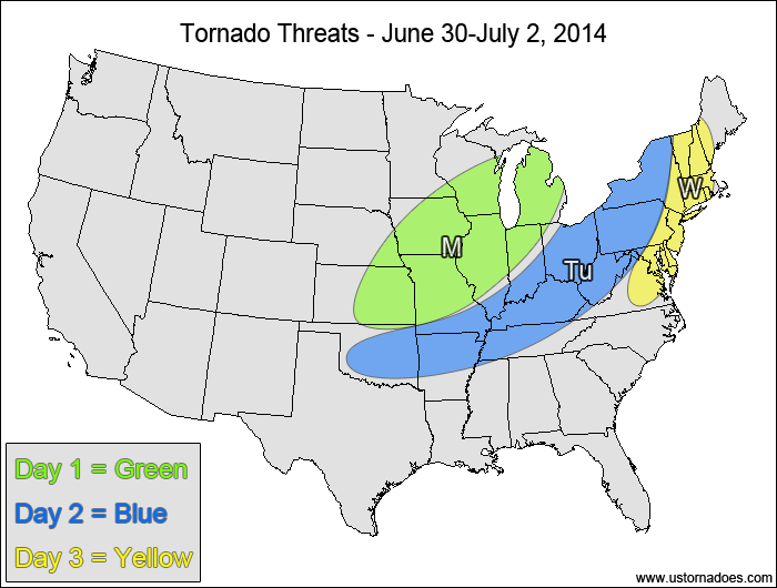
Monday
East-central Plains, Midwest — TORNADO RANGE: 3-8 — CONFIDENCE: Normal
Expected Tornado Hotspot: Western Midwest
Tuesday
Mid-Atlantic, southern Midwest, Tennessee Valley, Oklahoma — TORNADO RANGE: 2-6 — CONFIDENCE: Normal
Expected Tornado Hotspot: None
Wednesday
Northeast, Mid-Atlantic — TORNADO RANGE: 0-2 — CONFIDENCE: High
Expected Tornado Hotspot: None
4-7 Day
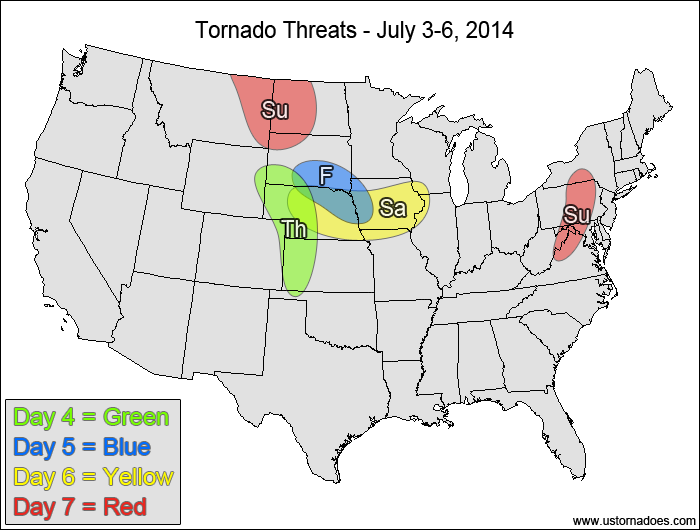
Thursday
Central High Plains — TORNADO RANGE: 0-2 — CONFIDENCE: Normal
Expected Tornado Hotspot: None
Friday
South Dakota, Nebraska, western Iowa — TORNADO RANGE: 0-3 — CONFIDENCE: Normal
Expected Tornado Hotspot: None
Saturday
Nebraska, western Midwest — TORNADO RANGE: 1-4 — CONFIDENCE: Normal
Expected Tornado Hotspot: None
Sunday
Northern High Plains — TORNADO RANGE: 0-3 — CONFIDENCE: Low
Expected Tornado Hotspot: None
Mid-Atlantic — TORNADO RANGE: 0-2 — CONFIDENCE: Normal
Expected Tornado Hotspot: None
Latest posts by Mark Ellinwood (see all)
- Spring 2023 seasonal tornado outlook - March 1, 2023
- Spring 2022 seasonal tornado outlook - March 1, 2022
- Spring 2021 seasonal tornado outlook - March 1, 2021