Still stuck in a fairly quiet pattern despite daily tornado threats… that’s what a stubborn cut-off low will get you on most occasions. The start of next week has the lowest potential for tornadoes, but things pick up again briefly around the middle of next week.
1-3 Day
Thursday
Central and southern High Plains, Texas, southern Louisiana — TORNADO RANGE: 1-4 — CONFIDENCE: Normal
Expected Tornado Hotspot: Central High Plains
Pros: Good directional shear, decent/good speed shear, low to moderate instability, good upper-level forcing in the High Plains.
Cons: Morning and afternoon clouds and showers contaminating the atmosphere, potential high LCL issues in the southern High Plains, no notable upper-level forcing in the southern parts of the risk area.
Friday
Central and southern Plains, Louisiana — TORNADO RANGE: 1-4 — CONFIDENCE: Normal
Expected Tornado Hotspot: West-central Plains, central Texas
Pros: Good directional shear, low to moderate instability, good upper-level forcing in the central Plains.
Cons: Potential veer-back-veer wind profiles in the central Plains, weak speed shear in the eastern parts of the risk area, no notable upper-level forcing in the southern parts of the risk area.
Saturday
East-central and southeastern Plains, southern Miss. Valley — TORNADO RANGE: 1-3 — CONFIDENCE: Normal
Expected Tornado Hotspot: None
Pros: Good low-level directional shear, low to moderate instability, decent upper-level forcing in the east-central Plains.
Cons: Fairly weak speed shear, veer-back-veer wind profiles in much of the risk area, very little upper-level forcing in the southern parts of the risk area.
4-7 Day
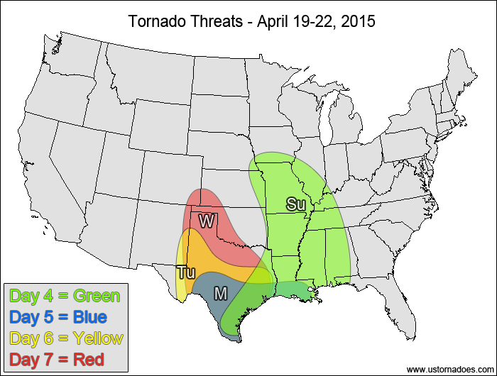
Sunday
Central and southern Miss. Valley, western Gulf Coast — TORNADO RANGE: 1-3 — CONFIDENCE: Normal
Expected Tornado Hotspot: None
Pros: Low to moderate instability, with pockets of somewhat high instability in the southern parts of the risk area, decent speed shear, good upper-level forcing in the central Mississippi Valley.
Cons: Mostly unidirectional winds for a large portion of the risk area, questionable storm coverage in the southern areas, morning/early afternoon clouds and rain limiting instability in the northern areas.
Monday
Southern Texas, southern Louisiana — TORNADO RANGE: 0-2 — CONFIDENCE: Normal
Expected Tornado Hotspot: None
Pros: Good directional shear.
Cons: Weak speed shear in the low-to-mid levels, fairly weak instability, no notable upper-level forcing.
Tuesday
Texas, eastern New Mexico — TORNADO RANGE: 0-2 — CONFIDENCE: Low
Expected Tornado Hotspot: None
Pros: Good directional shear, decent speed shear, some upper-level forcing.
Cons: Instability is fairly low, limited storm coverage, low-level speed shear is weak in most spots, upper-level disturbance and surface low are not well-defined.
Wednesday
Texas, central to southern High Plains — TORNADO RANGE: 2-6 — CONFIDENCE: Low
Expected Tornado Hotspot: Central to southern High Plains
Pros: Good directional shear, decent/good speed shear, low to moderate instability, some upper-level forcing.
Cons: Upper-level disturbance is not that well-defined, morning/afternoon clouds and rain, particularly across Texas, could limit the instability.
Latest posts by Mark Ellinwood (see all)
- Spring 2023 seasonal tornado outlook - March 1, 2023
- Spring 2022 seasonal tornado outlook - March 1, 2022
- Spring 2021 seasonal tornado outlook - March 1, 2021