Tornado highlights covering the week of May 3-9, and a brief look ahead.
A big story the last few years, and even into the beginning of this one, has been drought. Plains rain drought, and tornado drought. Neither is getting much play at the moment.
It goes hand-in-hand. Last week, we pointed to the big rain coming, and it just keeps on coming this year across the south. As the drought gets knocked back, critical surface ingredients for tornadoes have once again become plentiful. Add in an active jet-stream pattern, and spin.
The week just ended was a big one by any standard. We’ve got a few “down days” in the work week ahead, but things are looking mighty interesting after that.
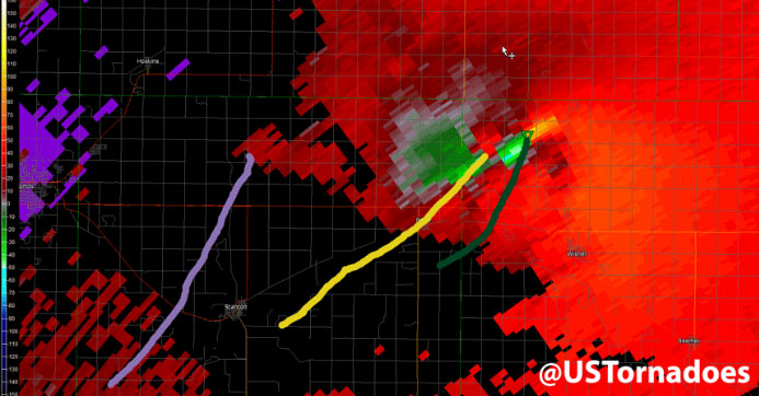
Last week’s summary map
And a few stats
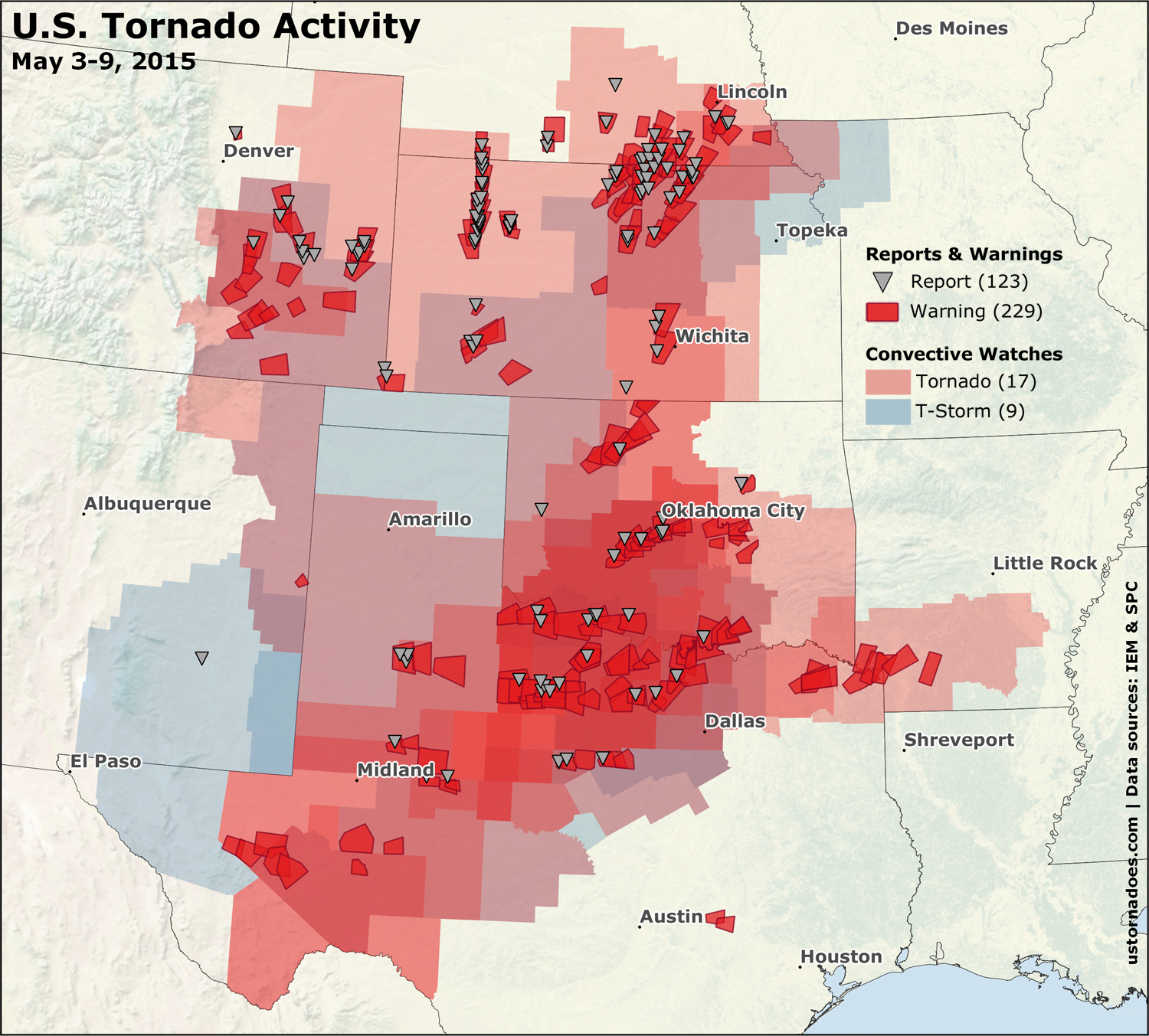
From May 3-9 ,there were 26 convective watches, of which 17 were tornado watches. 229 tornado warnings were issued and 123 tornado reports have come in as of publish. It was by far the busiest week of the year so far, and probably the busiest two-system set for the U.S. since 2011.
Related: Tornado Digest archives
If it seems like there have been a lot of tornadoes lately, there have. Following a slumber late April and into the first few days of May, we have now seen tornado reports every day since. We’re likely to break that streak ahead, but not for long.
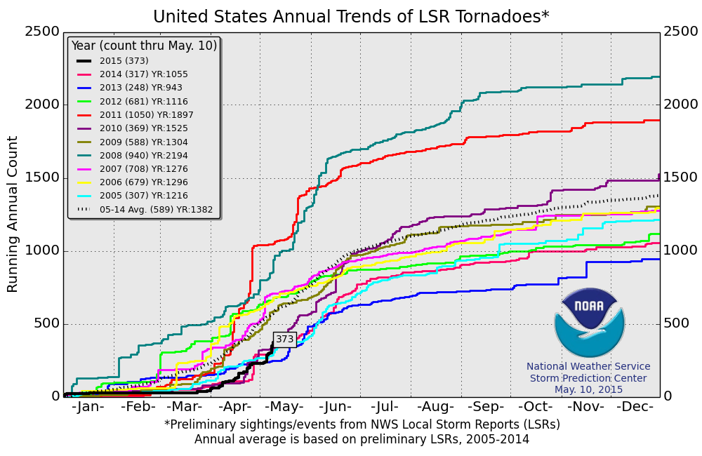
Figuring out tornado numbers while the counts are ongoing is usually a fool’s errand, but let’s assume there have been in the neighborhood of 100-120 tornadoes in the first 10 days of the month. That’s about the same total as the past three years combined over the same period. Of course, those years produced record-low tornado numbers.
We have to go back to at least 2010 for comparable numbers over the first third of May. That May 1-10 came in with 108 tornadoes. It was at the tail of a stretch of tornadic early Mays. 2009 had 131 tornadoes, 2008 saw 147 tornadoes, and 2007 came in with 182 tornadoes during the same period. The high and low for May 1-10, back to 2000, are 2003 with 365 tornadoes and 2011 with 11 tornadoes respectively.
May 3-4: Central and Northern Plains
(SPC May 3 event page) | (SPC May 4 event page)
These days are combined since they were both relatively small, and there’s a lot more to talk about later. Just pics, really.
Landspout east of Terril, IA taken ~6pm CT (5/3/2015) by Andrea Nelson. @NWSSiouxFalls @NWSDesMoines #IAwx pic.twitter.com/JN2KumKEDn
— Jayson Prentice (@SeverePlains) May 4, 2015
Tornado near Garden City, KS this evening. Image: Clyve Herbert/Jane ONeill, @AUSSKY pic.twitter.com/vBZDjUhPUs
— U.S. Tornadoes (@USTornadoes) May 5, 2015
May 5: Southern Plains, focus on Texas
An outflow boundary made for a brilliant midday. The first tornado of the day was a stunner in west Texas:
AMAZING #tornado today near Big Spring, TX! #txwx @breakingweather @NWSMidland pic.twitter.com/P7T27Yrz7U
— Brandon Sullivan (@btsullivan91) May 5, 2015
Later in the day, more convection fired off the dryline to the west. Additional tornadoes touched down including this one near Lubbock, Texas:
https://twitter.com/stormtimelapse/status/596046835354968064
May 6: Southern and Central Plains Tornado Outbreak
We waited, and after recent years we wondered. But a big day came, and we knew additional were still to follow. This was more of a “subtle” event when it comes to a big upper-level storm. Instead, classic low-level profiles up and down the Plains mixed with a relatively uncapped environment to deliver tornadic supercells to quite a large region.
Related: Videos from the May 6, 2015 Plains tornado outbreak
Large #tornado near Sedgwick, KS today, 4:57P CDT. Hwy 96 looking north. @NWSWichita @NatGeoCreative @NikonUSA pic.twitter.com/uCLVWLAzBx
— Jim Reed (@jimreedphoto) May 7, 2015
Tornado north of Verden, OK earlier. Was two, maybe three on the ground at once just prior. pic.twitter.com/rMXEBh5Jw4
— TornadoTitans.com (@TornadoTitans) May 7, 2015
Incredible, Scandia dodge a bullet, back at it tomorrow @USTornadoes @JWSevereWeather @JimCantore @NWSTopeka pic.twitter.com/sjF2zxC6la
— Benjamin Jurkovich (@BenjaminJurkovi) May 7, 2015
Classic Plains tornado outbreak satellite imagery. Even a big storm down in Mexico. pic.twitter.com/SebCgVJImY
— U.S. Tornadoes (@USTornadoes) May 7, 2015
May 7: Texas
This was a pause day without a pause. As the main trough began to push into the southwest, abundant upper level flow for supercells persisted across the southern Plains. As did lots and lots of moisture (something to watch this year ahead…). Despite mesoscale convective complexes (MCS) out the wazoo, more tornadoes formed.
JUST IN: @RickMitchellWX showing tornado video from NBC 5 viewers. http://t.co/M0kjWJAMrI#Tornado #dfwwx pic.twitter.com/DXcWECla5h
— NBCDFW Weather (@NBCDFWWeather) May 8, 2015
PIC – Picture of the tornado NW of Krum near FM 1173 about 1/2 mile south of FM455. (Picture: Tiffany Null) #txwx pic.twitter.com/gW4KrFGNwg
— DFW Scanner (@DFWscanner) May 8, 2015
It was a cruel week for many across the region. Denton, Texas — as one — faced tornado threats on multiple days during the stretch. The city was hit again on May 9.
Near Denton, Texas…
https://www.youtube.com/watch?v=71mDHhiWSAQ
May 8: Southern Plains
Wash, rinse, repeat. More big blobs of rain with outflow boundaries being spit out and supercells forming on the edges. Supercells then often quickly went high precipitation and decided to follow a river.
#tornado is a few miles away from #Throckmorton #Tx . pic.twitter.com/yCk91iEl36
— Travels & Chases (@TRAVELSnCHASES) May 8, 2015
https://twitter.com/stormhighway/status/596861330835054592
Large tornado north of Haynesville, Texas today! @SlingerWSYX6 @adamwsyx6 @AndrewWSYX6 pic.twitter.com/R1QrZVndpq
— Aaron Rigsby (@AaronRigsbyOSC) May 9, 2015
May 9: Southern/Central/High Plains Tornado Outbreak
A heck of a way to ruin a tornado outbreak. The main event came along as another in a strong of morning thunderstorm complexes attacked the main threat zone and took it off the menu for tornadoes. Comparative risks were lowered as we closed. But, plenty of twisters roamed.
Long-lived supercells dropped tornadoes across Colorado and Kansas. A significant and deadly tornado occurred in Texas.
Related: Videos from the May 9-10, 2015 tornado outbreaks
Big tornado we got just southwest of Cisco, Texas!!! pic.twitter.com/pdNUc8hADI
— Shawn McQuinn (@ShawnMcQuinn1) May 9, 2015
Another shot of the tornado SE of Kit Carson, Colorado earlier this evening. #cowx pic.twitter.com/k5eevxy1CI
— Justin Hughes (@jhughes722) May 10, 2015
The tornado outbreak series then continued into Sunday, but we’ll cover that part of it next week. You can check out the videos in the meantime!
Just getting started?
Pattern reload ahead, and there are signs active times will continue
With the slow start to May in 2011-2014, any active period seems hyperactive. And while it’s not yet time to oversell the tornado activity of late, the future certainly looks filled with plentiful opportunities to quickly up the twister count.
The recent tornado-maker is still headed east today. A relatively lower tornado threat continues along with it, focused on the Ohio Valley per SPC. While it clears out, the pattern takes a bit to re-jigger. But, not long.
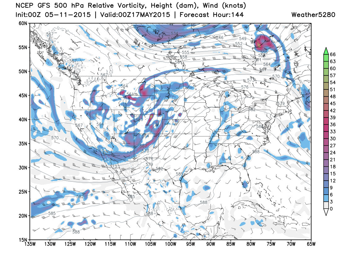
Before the weekend event, we’ll have to watch a wave in the flow about Wednesday that may linger into Thursday, but moisture return seems meager for that. The severe weather threat may begin to generally increase as soon as Thursday, and even more likely by Friday as the western trough takes over the pattern.
Morning and midday “instability destroying” showers and thunderstorms have recently reminded us that high-end potential can be tempered rather easily, but the large-scale pattern for next weekend is one with historical precedent for tornado outbreaks on a number of scales.
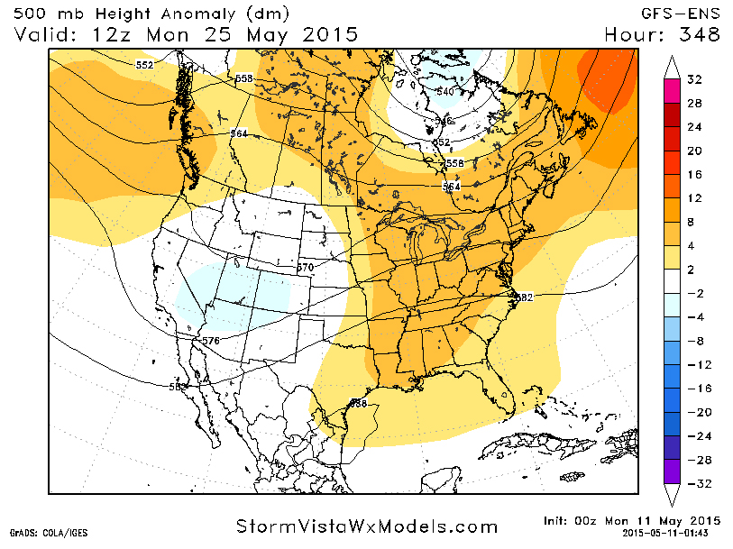
As with this time last week, ensemble modeling suggests the 1-2 week period ahead will be largely dominated by a tendency for storms to come in from the West Coast, and for high pressure to largely enjoy its stay in the east. This is suggestive of an overall active pattern continuing into the final third of May, and possibly beyond.
Latest posts by Ian Livingston (see all)
- Top tornado videos of 2023 - January 1, 2024
- March 31, 2023 tornado outbreak videos - March 31, 2023
- Top tornado videos of 2022 - December 31, 2022