After an active week consisting of two sizable tornado outbreaks, things calm down a bit for most of this week. As is typical in May, the lull in activity won’t last long, with another promising tornado setup looming on Saturday.
1-3 Day
Monday
Ohio and Tennessee Valleys, western Southeast, southern Texas — TORNADO RANGE: 2-7 — CONFIDENCE: Normal
Expected Tornado Hotspot: Ohio Valley
Pros: Low to moderate instability, good directional shear in Texas and Louisiana, good speed shear and upper-level forcing in the northern parts of the risk area.
Cons: Poor directional shear in most of the area that isn’t Texas or Louisiana, fairly weak speed shear in Texas and Louisiana, cold front forcing storms to become linear.
Tuesday
Southern High Plains, southern Texas, southern Louisiana — TORNADO RANGE: 1-4 — CONFIDENCE: Normal
Expected Tornado Hotspot: None
Pros: Good directional shear, low to moderate instability.
Cons: Little to no upper-level forcing, poor speed shear, messy/uncertain storm modes, morning and early afternoon clouds and rain within the risk area in Texas and Louisiana, little moisture in the High Plains.
Eastern Carolinas — TORNADO RANGE: 0-2 — CONFIDENCE: High
Expected Tornado Hotspot: None
Pros: Low to moderate instability, decent/good speed shear.
Cons: Fairly poor directional shear, questionable storm coverage, no upper-level forcing.
Wednesday
Central and southern High Plains, Texas — TORNADO RANGE: 0-3 — CONFIDENCE: Normal
Expected Tornado Hotspot: None
Pros: Decent/good directional shear, decent upper-level forcing in the High Plains.
Cons: Low instability in most spots, weak speed shear, early clouds and rain lowering instability and moisture return in Texas.
4-7 Day
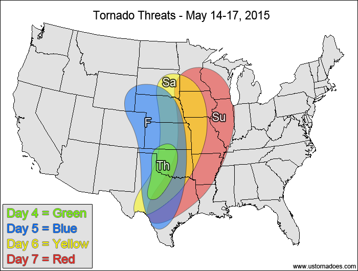
Thursday
Southern Plains — TORNADO RANGE: 0-3 — CONFIDENCE: Normal
Expected Tornado Hotspot: None
Pros: Good low-level directional shear, moderate to high instability.
Cons: Weak speed shear, some backing winds in the upper-levels, rising heights, low storm coverage, little to no upper-level forcing.
Friday
Plains — TORNADO RANGE: 3-8 — CONFIDENCE: Normal
Expected Tornado Hotspot: Central Plains
Pros: Good directional shear, low to moderate instability, some upper-level forcing.
Cons: Speed shear is weak in most spots, heights are rising or neutral
Saturday
Plains, western Midwest — TORNADO RANGE: 16-40 — CONFIDENCE: Low
Expected Tornado Hotspot: None
Pros: Moderate instability, good directional and speed shear, good upper-level forcing.
Cons: Winds are fairly unidirectional in the mid-to-upper levels.
Sunday
Eastern Plains, Miss. Valley, western Midwest — TORNADO RANGE: 6-16 — CONFIDENCE: Low
Expected Tornado Hotspot: Western Midwest
Pros: Moderate instability, good speed shear, okay directional shear, good upper-level forcing in the northern parts of the risk area.
Cons: Speed shear is lackluster in the southern parts of the risk area, cold front could line storms out more quickly, surface low is in the process of weakening.
Latest posts by Mark Ellinwood (see all)
- Spring 2023 seasonal tornado outlook - March 1, 2023
- Spring 2022 seasonal tornado outlook - March 1, 2022
- Spring 2021 seasonal tornado outlook - March 1, 2021