
May 4 update: Grading the outlook
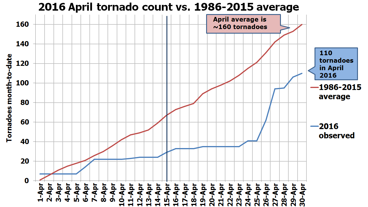
April has come and gone. It’s time to take a look back at how the tornado forecast panned out. Grading the outlook is key to learning where it erred, so here we go…
[Tracking the tornadoes of 2016]
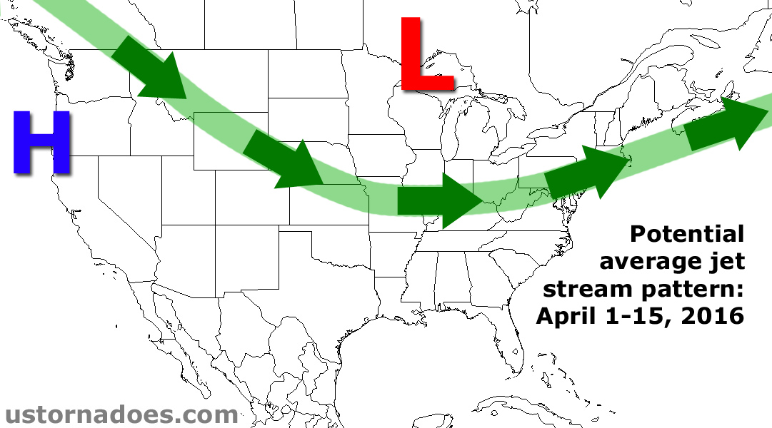
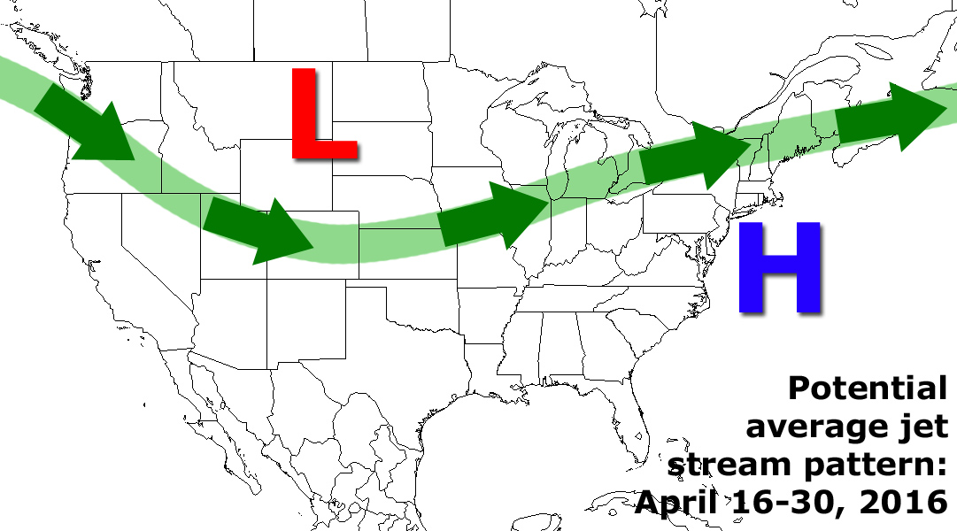
Overall, the idea of a slow start to the month and a busy finish was spot on, although some factors did prevent the forecast from nailing every exact detail. A tendency for low pressure across southeastern Canada and parts of the Northeast hung around longer than expected, effectively delaying the pattern change from mid-month (as forecast), to the last week of the month. It wasn’t until around April 24 that the pattern was dominated by low pressure in the West and high pressure in the East, which favors more robust tornado activity. If it were not for the 7-10 day delay and the extremely slow start to the month, tornado activity for the month very well could have finished near or even above average.
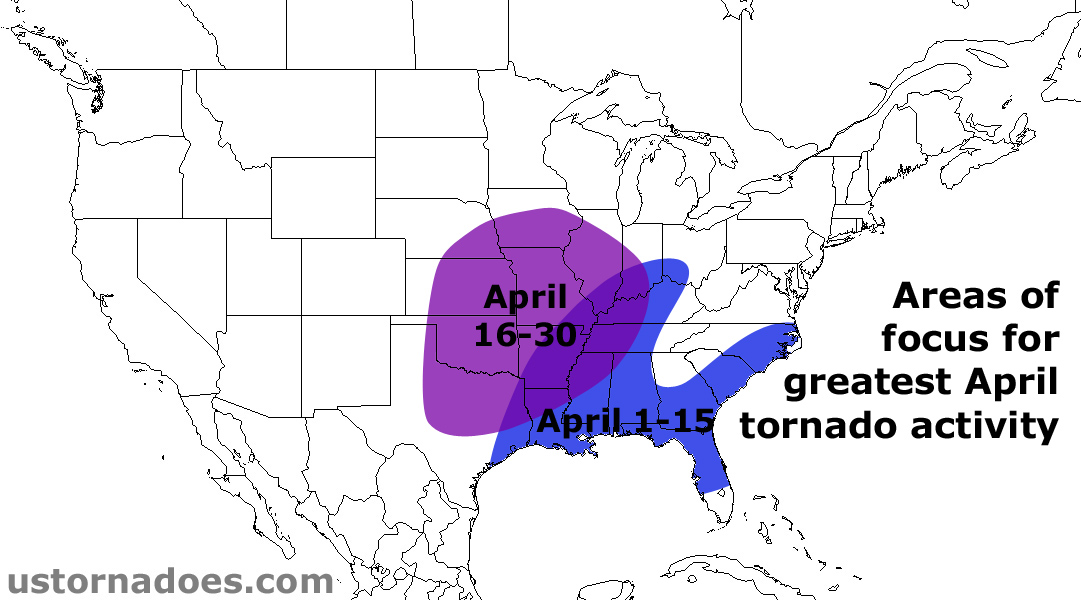
In terms of areas of tornado activity, the forecast was generally correct in favoring the Southeast during the first half of the month. As predicted, the second half of the month saw a large shift to the northwest, including some relatively early season “northern” tornadoes in Iowa, Minnesota and Nebraska.
Grade: B – Pretty solid for the general pattern and tornado placement, but was a little bit too quick with the idea of the pattern change.
This recap was last updated on May 4, 2016. Original post below.
April tornado outlook
This year continues to be off to a seemingly early start for severe weather across the United States. Tornado numbers are running near average on the year, which is a drastic change over what was seen during the past three years, when the “tornado season” took several months to get going. As we move deeper into spring, the tornado season typically starts to heat up, while gradually shifting north and west into the Great Plains and Midwest.
There is reason to believe that the pace of thunderstorm and tornado producing weather events seen so far in 2016 will continue into April. At the same time, heading into the three-month peak of the tornado year, coverage and intensity of severe events is likely to pick up as well.
The meat
After starting on the slow side in April, tornado activity is expected to increase through the middle and latter portion of the month.
Odds favor the U.S. tornado count to be near to perhaps somewhat above the average of 155 tornadoes (1991-2010 average) for April:
Below average: 15% (less than 130 tornadoes)
Near average: 50% (between 130 and 180 tornadoes)
Above average: 35% (more than 180 tornadoes)
The details
Coming out of a strong El Niño winter, the severe season so far has, in some ways, not “followed the rules” of what is usually expected during El Niño.
Generally, cooler than average temperatures are favored over the South in an El Niño winter, with places such as the Gulf Coast and Florida tending to see an uptick in tornado frequency. While these areas have been at or above average tornado number since late 2015, activity has also spread much farther north than usual.
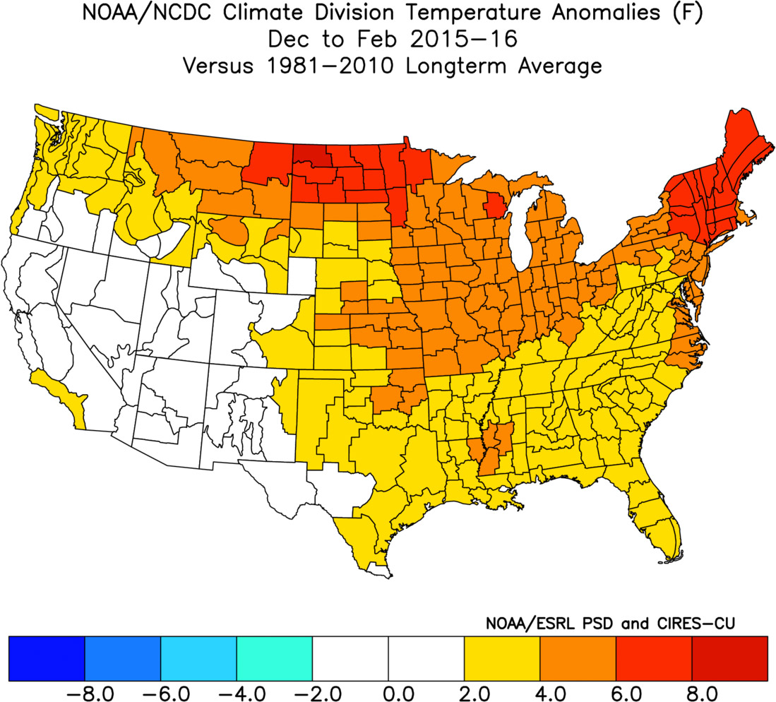 Much of this was likely driven by the fact that meteorological winter 2015-16 (December-February) was the warmest on record across the Lower 48.
Unlike recent winters, that were dominated by large troughs of persistent low pressure across the eastern United States, there was considerable ridging in the East, allowing for warm and sometimes unstable air to stray farther north than usual. This contributed to a rare February Mid-Atlantic/Northeast tornado outbreak on the 24 and the recent early-season tornadoes in the Midwest on March 15th.
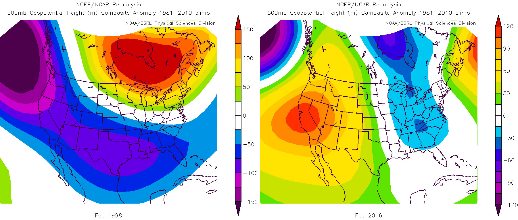 Although our seasonal outlook mentions 1998 as a prime analog for spring as a whole, and it’s likely that some similar influences will occur at times, the upper air and surface temperature patterns in our part of the world in early 2016 have been almost the complete opposite of what was observed coming out of the strong El Nino in 1998.
When considering this observation and the ensemble forecasts moving forward over the next four to six weeks, it appears that El Niño-Southern Oscillation (ENSO) analogs, at least for 2016, demonstrate limited and inconsistent skill in making monthly predictions with respect to severe weather. This outlook for April will focus more on the upper air (500mb) analogs and ensemble forecasts.
March 2016 has continued the general theme of meteorological winter, with low pressure troughing in the Northwestern United States and high pressure ridging across the East.
The middle of March has seen a bit of a deviation from that trend, allowing for some cooler air and snow to threaten portions of the Great Lakes and Northeast. Despite some warmer days this week, these negative height anomalies (indicating lower pressure in the region) may try to persist through the balance of March on average, particularly from central and eastern Canada into the Great Lakes.
There are also suggestions that high pressure ridging returns to the Northeast Pacific, which will be a key factor discussed below. This has come into focus within the medium range forecast models and ensembles. Both the American ensembles (GEFS) and European ensembles (EPS) are in fair agreement with this evolution of the weather pattern. Please note that computer forecast models are not perfect and that weather patterns can evolve differently than projected in these model depictions.
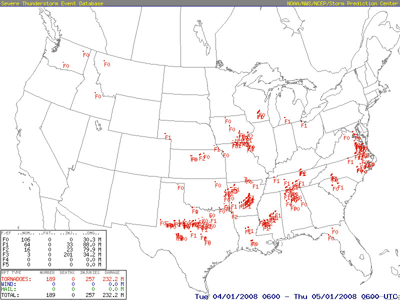
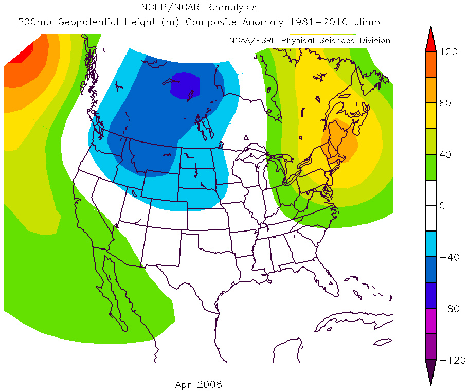
Perhaps the best loosely matched analog for April 2016, given the upper air pattern forecasts and severe weather trends, is 2008, based on subjective analysis. This year has already featured the most tornadoes in any February since 2008. Aside from 2012, this year has also featured the busiest early tornado season since 2008. (January through mid-March)
That active April of 2008 featured 189 tornadoes, and I expect this April to be near to slightly above average in terms of tornadoes, but it probably won’t be quite as active as 2008.
The Euro weeklies generally show a transition from eastern Canada/Northeast U.S. troughing during the first week of the month to a more zonal pattern by the second week. The high pressure ridging in the West may not be ideal for tornado activity across the Plains during this time. It’s too early in the season for northwest flow to do much out there with a relative lack of moisture that takes several weeks to migrate northward through the spring.
Additionally, low pressure troughing over the Northeast is not ideal either for severe weather, but the weeklies and support from the monthlies, indicate this pattern breaking down by mid-April. Assuming the jet realigns farther north by the second week of April, this will loosely follow 2008, where above average tornado activity was observed in the Midwest. The pattern appears to favor a faster flow as opposed to “blocky” setups. This could end up favoring a fairly steady stream of severe threats, although not necessarily a high-end individual event.
It should be noted that 2008 is being used as a loose analog, so do not expect 2016 to be exactly the same. Other loose early spring analogs, including 1955 and 1963, also saw an increase in tornado activity in the Midwestern states in April. In both cases it was mainly a function of positive height anomalies and the resultant high pressure ridging along the East Coast.
For the first half of April, the forecast jet stream trajectory may limit appreciable instability to the Gulf Coast, Florida and perhaps the Carolinas, where some tornado activity remains possible. Most other areas could be on the quieter side in terms of severe potential. By the second week of April, an enhanced tornado threat zone is delineated across the Mid-South to Ohio Valley, where greater than average tornado activity is anticipated.
This outlook is a compromise between climatology (all Apr tor, strong Apr tor, locations) and the 1955/1963/2008 analogs. The jet stream is expected to retreat north, but not as far as it was in some of those years mentioned. The Plains can expect near or somewhat below average tornado activity during this time, especially if ridging dominates the West. Fairly typical tornado activity for early April is forecast across the Gulf Coast states and adjacent Southeast.
Into the second half of April, high pressure ridging in the West is projected to break down, which can been noted in the Euro monthlies and latest weeklies, as some low pressure troughing may return to the West. This also coincides with climatology, suggesting that the Plains tornado season — typically peaking from April/May into June/July — begins to get underway. Such an evolution of the pattern has been shown in the ensembles for several runs in a row, giving relatively strong confidence in this scenario.
As a result, there are indications that the second half of April will be more active than the first, perhaps much more active, likely delivering at an above average pace.
A consideration not yet discussed is the amount of available moisture across the Lower Mississippi Valley and Deep South.
2016 has been very wet so far in these areas and this moisture supply, while working in tandem with a southerly flow from the Gulf of Mexico, should be able to transport quality moisture into the southern and central Plains by late April. Earlier in the 2010s, a drought across parts of the south-central states worked to mitigate the frequency of tornadoes, particularly early in spring. That pattern broke down last spring and is no longer an issue. Above average sea-surface temperatures in the Gulf (moisture source) and limited deep, cold air intrusions from the north have also played a role into a return to near average tornado numbers.
A question chasers may want answered is, will this lead to a tendency for high precipitation supercells like 2015?
That is a difficult question and while it is not out of the question, the frequency of elevated mixed layer (EML) plumes and tornado events performing and sometimes over performing in marginal moisture (upper 50s dew-points) situations thus far in 2016 suggests a more optimistic look at (chaseable) tornadoes during April.
The central Plains to Middle Mississippi Valley are highlighted for potentially seeing the most above average tornado activity during the second half of April, as the western ridge gives way to dips south in the jet stream. This should bring a threat for a few tornado events to the central states to during the latter portion of April. Most other areas in the U.S. are projected to see near average tornado counts, but if “Southeast” ridging comes into play with a favorably timed trough, tornado occurrence may also increase relative to climatology across the mid-Atlantic region. Note that recent ensemble forecasts show significant ridging in the East by late April, but it remains to be seen if there is a ridging bias in the long range within these models, so the evolution of pattern trends will need to be monitored into April.
Finally, it should be noted that the extended Euro weeklies and CFS have also shown a very consistent trend toward a more northward than usual shift in the jet stream by late April. This could lead to an early start to a May-like pattern, somewhat farther north than the climatologically favored southern Plains to Lower Mississippi Valley region for the pattern portion of April. The end result is expected to be similar to April 2008, especially for the second half of April 2016, with positive height anomalies (tendency toward high pressure) across the East. As previously mentioned, ridging in the East is expected by late in the month, which happens to also align closely with April 2008.
Disclaimer and note: Long term forecasts are educated predictions based on a number of considerations, including computer model forecasts, historical patterns and recent trends. They are intended to give a general idea of what is expected to take place in the coming weeks, but are not flawless and may have limited skill. These broad outlooks cannot account for small scale events or deviations from the projected weather patterns. The bottom line is that it is always a good idea to routinely check the most updated weather forecasts for the latest information.
The plan is to do these monthly outlooks for at least the peak months of the year. They will be refined as they are done and we better learn what works and what doesn’t.
Latest posts by Quincy Vagell (see all)
- How peak tornado season ends up active or quiet in the Plains - May 14, 2019
- Low tornado count set to continue through the end of April, but it’s too early to call the season - April 21, 2018
- June 2016 tornado outlook - May 23, 2016


Thank you what time of the month will you be posting the forecast?