This is part two of a six part series on tornado outbreak sequences. If you haven’t yet, you might want to start at the beginning with how they come together.
Given the knowledge of what is generally needed to get an outbreak sequence to occur, let’s begin looking at a sample of the most notable ones in history.
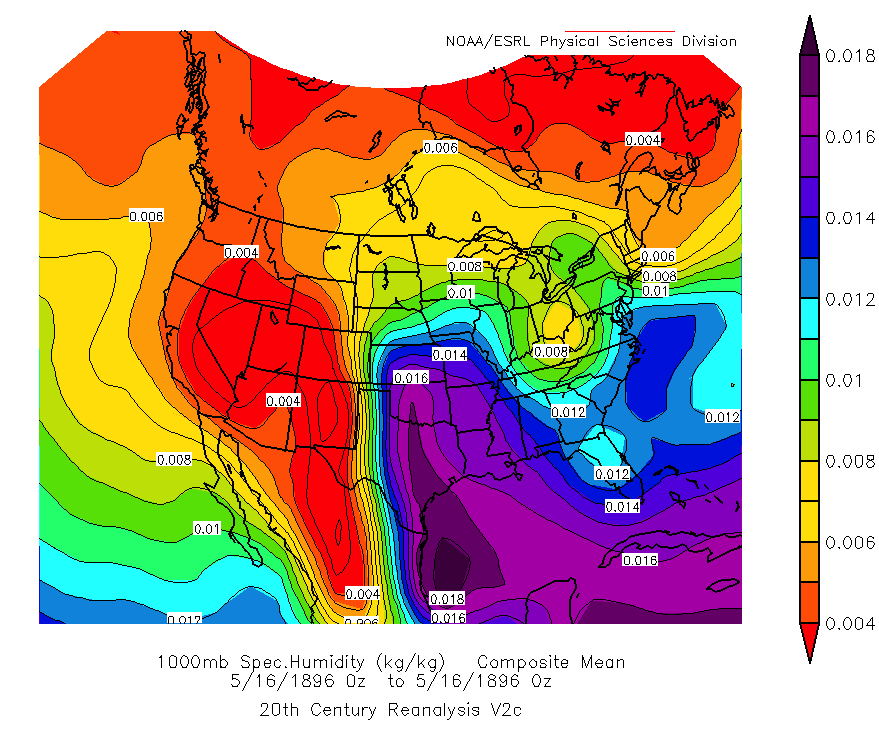
Perhaps the first widely recognized case of a tornado outbreak sequence in the United States came during the second half of May in 1896. Large scale low pressure troughing in the mid/upper levels across the Pacific Northwest and the western Canadian Prairie provinces combined with a strong mid/upper level ridge of high pressure centered over the Mid Atlantic. This developed a large scale pattern favorable for significant severe thunderstorms over a nearly two week period, from May 15 to May 28.
At least five major tornadic events occurred (with smaller instances sprinkled in between) during the sequence, with devastating results for residents from the central and southern Plains eastward into the Mid Mississippi Valley and Great Lakes.
The first shortwave trough of the series amplified along the West Coast and shifted into the Four Corners region through the afternoon of May 15. A very moist and likely strongly unstable air mass existed over the Red River Valley of Texas and Oklahoma, out ahead of a dryline stretching across western Texas.
In response to the height falls from the mid-level shortwave trough and a developing surface lee cyclone over eastern New Mexico, a healthy southerly low level jet with 850 mb wind speeds approaching 40 knots developed across north-central Texas and south-central Oklahoma by 00z May 16. Pressure falls associated with the low also led to a backed near-surface flow, which enhanced moisture convergence and directional shear in the low levels, suggesting a primed environment for tornadic supercells was in place.
Before going further, it should be noted that tornado ratings (via the Fujita Scale) prior to 1950 are not considered official. The ratings given in the following case studies earlier than 1950 are based on Tom Grazulis’ book, Significant Tornadoes, and are obviously subject to interpretation. In addition, many of the long-tracked tornadoes documented in this era were likely two or more separate tornadoes spawned by the same supercell (known as a tornado family).
While it is not known exactly how many tornadoes did develop on May 15 (as is the case for all tornado events prior to the modern detection era), what is known is that at least one supercell developed in north-central Texas and began producing tornadoes north of Dallas/Fort Worth. Two strong tornadoes (one rated F3 and the other F2) moved across Denton County, causing extensive damage to at least 30 homes and five fatalities between them.
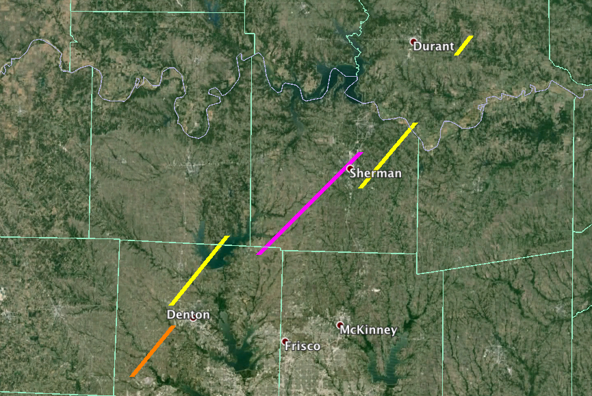
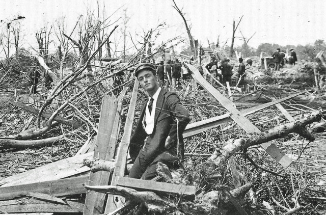
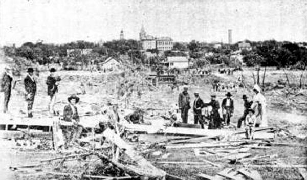
The most destructive tornado of the day developed soon thereafter east of Pilot Point in northeastern Denton County and tracked for over 25 miles into Grayson County. Multiple farmsteads were obliterated by the large and violent tornado as it shifted north-northeast towards the bustling town of Sherman. The storm was likely in its occluding (i.e. dissipating) stage as it moved into the north side of Sherman. However, despite the storm shrinking in size, it lost none of its extreme intensity.
The Houston Street Bridge (constructed mainly of iron) was ripped from its supports and deformed into warped, unrecognizable pieces and trees were reported debarked and sheared off near ground level. At least 50 homes were demolished as it tore through the city, with no less than 20 of them completely razed and swept away.
At least 73 deaths were confirmed with over 200 injured by the F5 tornado, some of the victims being blown long distances from their original location. This made it the fourth deadliest tornado in Texas’ tornado-troubled history (the linked list only goes back to 1900), and also perhaps the worst in the Red River Valley region. Several other tornadoes developed into south central Oklahoma across the Red River and also in southern Kansas. This included one that killed four near Blue, Oklahoma in Bryan County, bringing the death toll from the first day of the sequence to at least 83.
The pattern “reload” (in which the ingredients for severe weather return) occurred heading into May 17. The initial mid-level shortwave trough responsible for the Sherman disaster shifted east into the Great Lakes and Ohio Valley, and another emerged toward the central Plains. An entire family of five was killed in a single home near Elva, Kentucky by an early morning F2 tornado. The attention shifted back westward in the late afternoon as two long-tracked tornadoes (possibly tornado families) cut paths across northeastern Kansas. The former of this tandem was an F3 with a 45 mile track that dismantled at least seven farms and a church in Riley County. 58 people were injured alone at the second location.
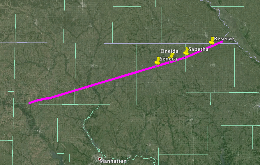
The latter was monstrous, over a mile wide at times, that plowed a 100 mile streak through Washington, Marshall, Nemaha and Brown counties in northern Kansas. It then crossed the state-line into Richardson County, Nebraska near Falls City before dissipating. Numerous farmsteads along the path were obliterated and left essentially bare by the estimated F5 tornado. The towns of Seneca, Oneida, Sabetha and Reserve in Nemaha and Brown Counties were also hard hit. The opera house and courthouse in Seneca were destroyed and only three structures in Reserve escaped unscathed. 21 fatalities occurred in Kansas with a further four in Nebraska, for a total death toll of 25. Over 200 injuries were also documented along the track of this tornado.
Further significant tornadoes occurred across the central and southern Plains during the three day stretch from May 18 to May 20, fortunately with no lives lost. Unfortunately though, the worst of the outbreak sequence was still yet to come following a brief lull from May 21 to May 23 (although it is very possible there were several, undocumented tornadoes in this timespan).
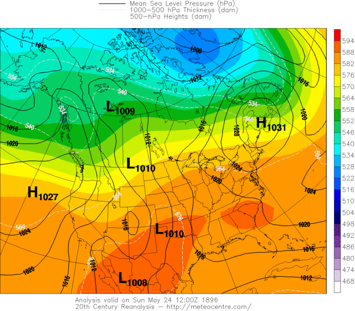
The sequence kicked into overdrive late on May 24 as the next in the series of shortwave troughs emerged into the northern Plains towards the Missouri River Valley.
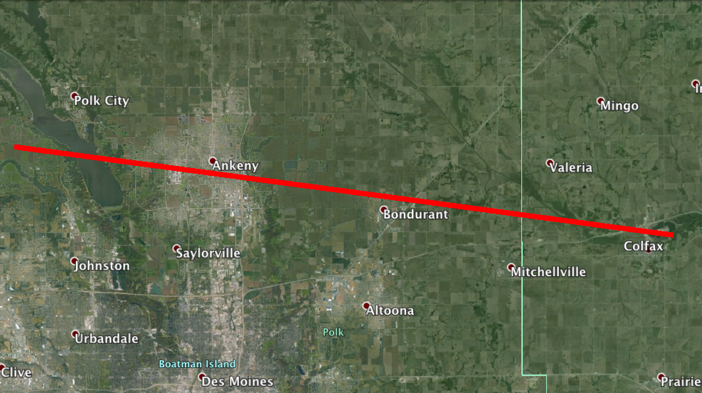
A deepening surface low shifted along the Canadian border and high pressure ridging to the south ensured that, once again, an extremely moist warm sector was available to this low as it translated eastward. After sunset, an east-southeast moving F4 caused major damage in the northern suburbs of Des Moines, Iowa. Multiple homes near Bondurant and Valeria were levelled by the tornado, and part of a railroad track at one location was skewered into the ground to a depth of nearly 15 feet. 21 people lost their lives and over 60 further were hurt. This was one of the worst tornadoes to occur in the immediate vicinity of Des Moines.
Conditions became more favorable for a broader-scale outbreak of severe thunderstorms and tornadoes the following day across the Great Lakes region. The same richly moist and unstable thermodynamic environment that was present the day before was advected northeastward. However, the mid-level shortwave trough was now reaching maturity, and the surface low had deepened significantly, below 995 mb, indicating stronger wind fields would likely be in place.
Early in the morning on May 25, several significant tornadoes sped across northern Illinois, including an F4 in Ogle County that caused four deaths when a large house was swept away near Egan. Three others were killed by an F3 that tracked close to the path of the April 9, 2015 Rochelle/Fairdale EF4 tornado. Another F3 tornado tore a five mile path through the northern Chicago suburbs of Park Ridge, Edison Park and Norwood Park, although surprisingly it did not result in any fatalities.
The outbreak heightened its ferocity into the early/mid evening hours across eastern Michigan. The now densely populated area of Mount Clemens north of Detroit was affected by a long-tracked F3 that significantly damaged at least 30 homes and killed two people before crossing the international border into Canada, staying on the ground for 35 miles. Another death was attributed to an F3 that passed through Bay and Tuscola Counties.
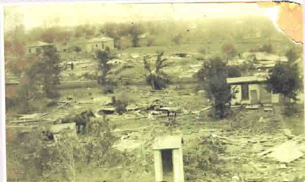
One of the worst tornadoes in Michigan’s history then followed at around 02z (10 p.m. EDT). It developed in Oakland County and proceeded to tear a 30 mile swath of near complete destruction into Lapeer County. The villages of Ortonville, Oakwood and Thomas all suffered extreme damage with numerous homes erased, with the second of these locations never being rebuilt. Nine fatalities occurred as a single home was annihilated in Ortonville. A survey from the Weather Bureau in the Thomas area noted that the center of the damage track was basically trampled down by the violent tornado, with trees and even small twigs completely stripped of their foliage and bark. Becoming the second deadliest in Michigan on record, this F5 tornado left 47 deaths in its wake and over 100 injuries.
Already in the 10 day span between May 15 and May 25, the sequence had claimed over 150 lives and resulted in three F5 tornadoes, but far worse still was to occur two days later, as the final tornado outbreak of the sequence targeted the Mid Mississippi Valley.
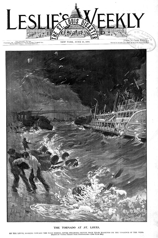
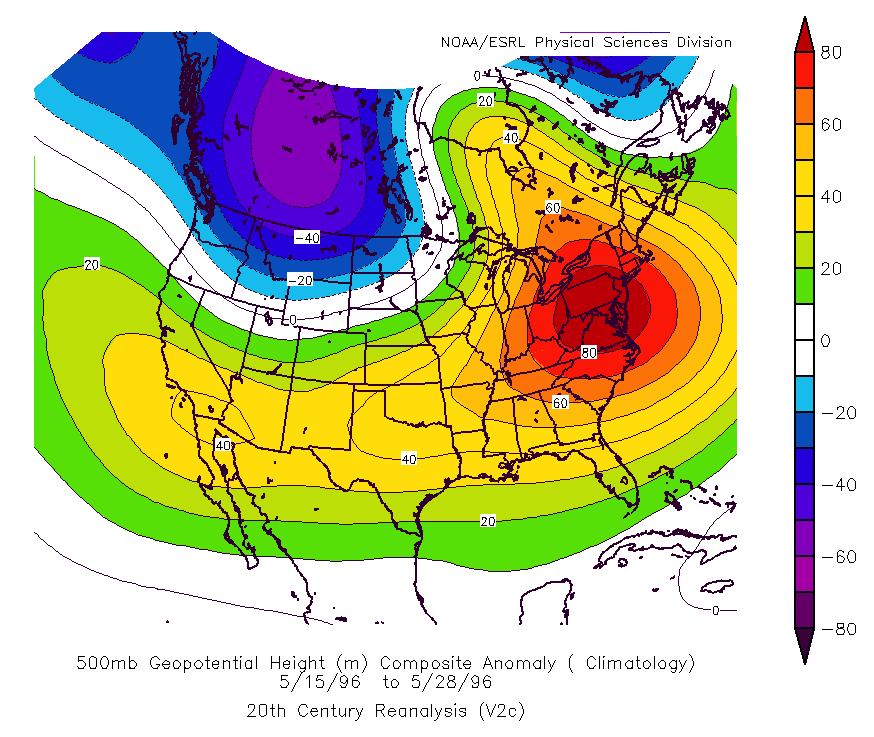
The city of St. Louis was one of the main commercial and industrial sites in the United States in the 1890s. Steam boats traveling up and down the Mississippi River transporting people and goods used St. Louis as one of their main hubs, supporting a booming economy and rapid population growth. Over 500,000 people called the city home by 1896, and it possessed one of the largest GDPs in the United States. However, as the city prepared for the 1896 Republican National Convention, the last in the series of shortwave troughs associated with the outbreak sequence moved through the central Plains, leaving the Mid Mississippi Valley directly within the bulls-eye of an onslaught.
The same buoyant and uncomfortably humid air mass that had resulted in the tornadoes prior remained in place and temperatures rose into the mid 80s by mid afternoon. A strong 500 mb jet max nosed into the Lower Missouri River Valley, with a surface low moving from the central Plains into southeast Iowa by 00z May 28. This again provided enhanced vertical shear for robust severe convection and the potential for a regional tornado outbreak.
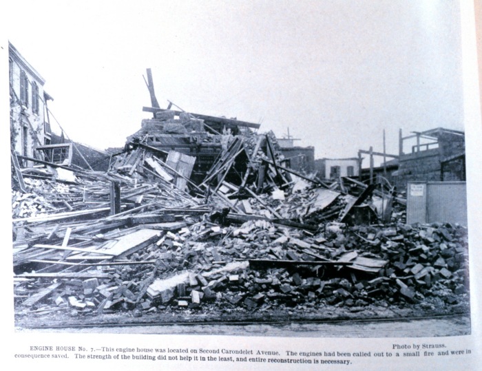
Several tornadic supercells formed across Missouri during the mid afternoon hours of May 27 and tracked eastward. The first fatality of the day occurred east of Bellflower as a church and barn were destroyed by an F2 tornado. Two more killer tornadoes (rated F3 and F4 respectively) struck Audrain (at least 6 dead) and Osage (2 deaths) Counties before one of the worst tornado disasters in United States history began churning through the metropolitan area of St. Louis around 7:30 p.m. CDT.
Moving east-northeast into the heart of the city, hundreds of structures including saloons, factories, homes and schools were destroyed by the half mile wide tornado before it reached the Mississippi River. Lafayette Park suffered significant damage with many trees taken down and a barometer in the area measured a drop in pressure to 906 mb as the tornado passed (nearly a 100 mb drop from the ambient environment). At least 137 people were killed and hundreds further were injured by the storm on the Missouri side of the river.
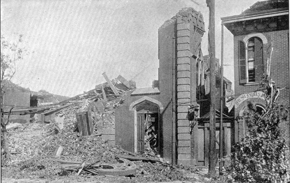
Similar to the Sherman calamity twelve days prior, the tornado shrank slightly, but may have intensified as it crossed the Mississippi River into East St. Louis, Illinois. It is likely that further fatalities occurred on boats on the river, but were not documented because they were swept downstream. In East St. Louis, near F5 damage was incurred to many areas as several neighborhoods were decimated, including the Vandalia Railyard, where at least 35 people were killed. A wooden board was torpedoed through a wrought iron plate at the severely damaged Eads Bridge and many brick buildings were flattened to the ground.
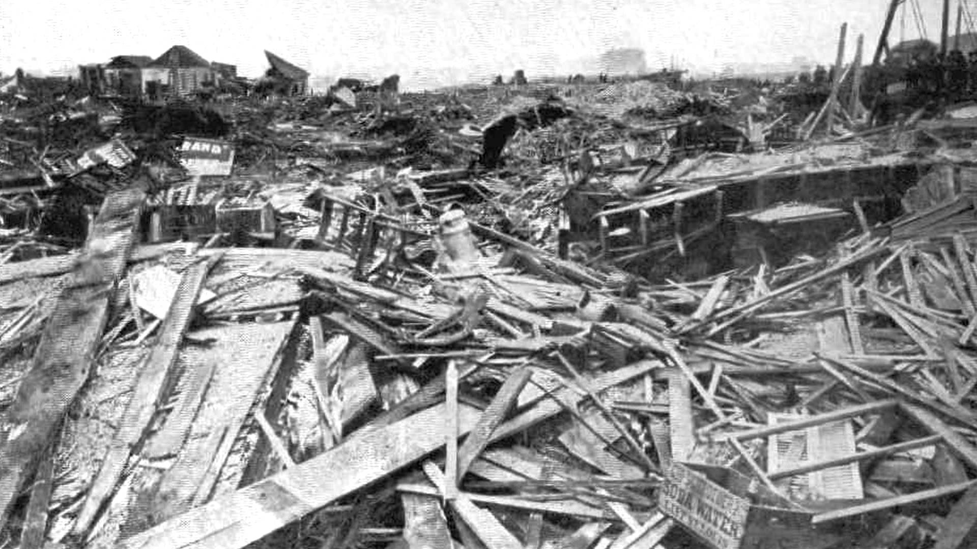
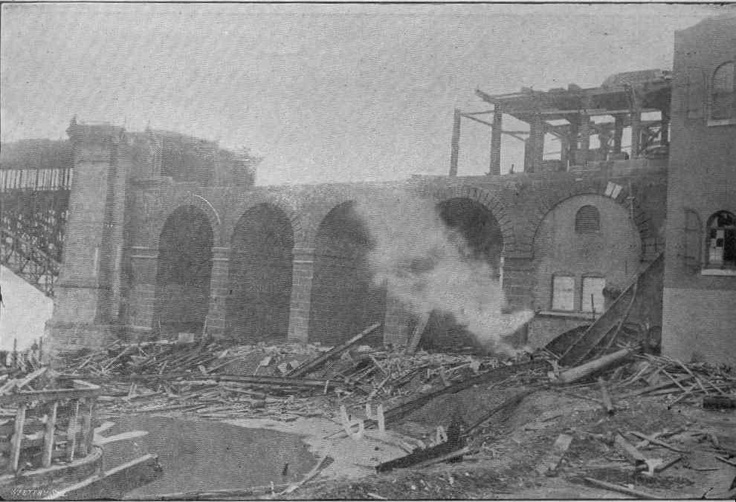
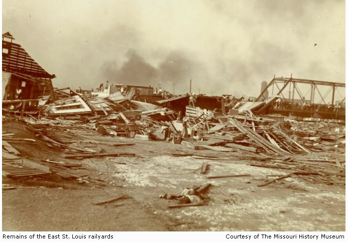
At least 118 further were killed in East St. Louis before the catastrophic tornado wound down on the east side of town after twelve miles of carnage. Rated F4, it still stands as the third deadliest tornado to occur in North America, with 255 or more fatalities and greater than 1200 injuries. Adjusted for inflation, it is also one of the costliest tornadoes on record, with greater than $3.5 billion in losses. There were considerations of moving the Republican National Convention away from St. Louis in the wake of the tornado, but it continued as planned.
The outbreak continued into the evening with three long-tracked tornadoes leaving trails of death and destruction across central and southern Illinois. The first was an F4 that careened through Washington and Jefferson Counties east of New Minden as it wrecked numerous farms along a 23 mile path, claiming 14 lives. Second of the trio was another F4 that tracked 30 miles through St. Clair and Clinton Counties. 13 people were found dead in the ruins of the town of New Baden, where multiple homes were smashed to pieces. 10 died initially in St. Clair County where train stations were skirted and another died near Germantown, to bring the total from this tornado to 24 with 125 others injured. An F3 was the final of the three, passing just south of the original tornado track through Washington and Jefferson Counties, laying waste to more farms and resulting in three more deaths.
May 27, 1896 remains one of the deadliest single tornado outbreaks in United States history, with over 300 killed by at least seven separate tornadoes in Missouri and Illinois. With the death toll from the outbreak sequence now approaching 500, the final day, May 28, brought more tornadoes to the Eastern Seaboard as the shortwave trough progressed towards the Atlantic. An F3 tracked 35 miles through eastern Pennsylvania into New Jersey, killing four and one other death occurred in Columbia, Pennsylvania. This finally brought the outbreak sequence to a close, as ridging took over the central United States.
The May, 1896 tornado outbreak sequence still is the deadliest of its kind in United States history. No less than 484 people were killed by no less than 38 killer tornadoes during the 13 day span between May 15 and May 28, along with thousands of injuries. Tom Grazulis remarked that the span between May 24 and May 28 may have been the “most violent single week of tornado activity in United States history”. Largely due to this sequence, the 1896 tornado season stands as one of the deadliest in United States history, with over 500 people killed. It was a textbook example of how destructive a series of tornado outbreaks over a short time-span can be, especially before the era of modern tornado detection and warning.
Next time, we look 21 years later at the May-June, 1917 tornado outbreak sequence.
Sources/Other Recommended Material:
ESRL (CIRES) 20th Century Reanalysis: http://www.esrl.noaa.gov/psd/data/20thC_Rean/
Harold Democrat Sherman tornado article: http://heralddemocrat.com/blog/donna-hunt/donna-hunt-1896-black-friday-devastated-sherman.html
Gen Disasters Sherman tornado article: http://www3.gendisasters.com/texas/11135/sherman-tx-tornado-may-1896
Gen Disasters Seneca tornado article: http://www3.gendisasters.com/kansas/6626/ks-seneca-tornado-may-1896
UQAM Reanalysis (derived from 20th Century and NCEP/NCAR Reanalyses): http://meteocentre.com/reanalyses/get_reanalyses.php?lang=fr&mod=20cr&area=na
Oakland Press Ortonville tornado article: http://www.theoaklandpress.com/article/OP/20090621/NEWS/306219938
Monthly Weather Review -> May 25, 1896 Michigan tornadoes report: http://docs.lib.noaa.gov/rescue/mwr/024/mwr-024-05-0156a.pdf
Press & Guide Ortonville tornado article (contains damage photo): http://www.pressandguide.com/articles/2012/03/16/news/doc4f638db0510c5871341303.txt
St. Louis Public Library page on the tornado: http://tornados.slpl.org/
Hill ‘n Holler St. Louis tornado article: https://hillnholler.net/2013/06/02/tornado-wise-st-louis-has-a-target-on-its-back/
NOAA Photo Library (St. Louis tornado damage): http://www.photolib.noaa.gov/htmls/wea00266.htm
Weather History St. Louis tornado video: https://www.youtube.com/watch?v=LzbvKkYtkUQ
Distilled History St. Louis tornado article: http://www.distilledhistory.com/1896cyclone/
Tornado Project Wayback Machine page (Tom Grazulis reference): https://web.archive.org/web/20140226141138/http://tornadoproject.com/past/pastts95.htm