IT’S LATE MAY! Just as you would expect during peak tornado climatology, we’re heading into a more active period starting at the end of this week.
Ian is out chasing! Go check him out on Twitter because he posts there a lot: @islivingston
Just a heads-up… there will be no Tornado Threat Forecast on Monday (May 23), because I will be out of town.
1-3 Day
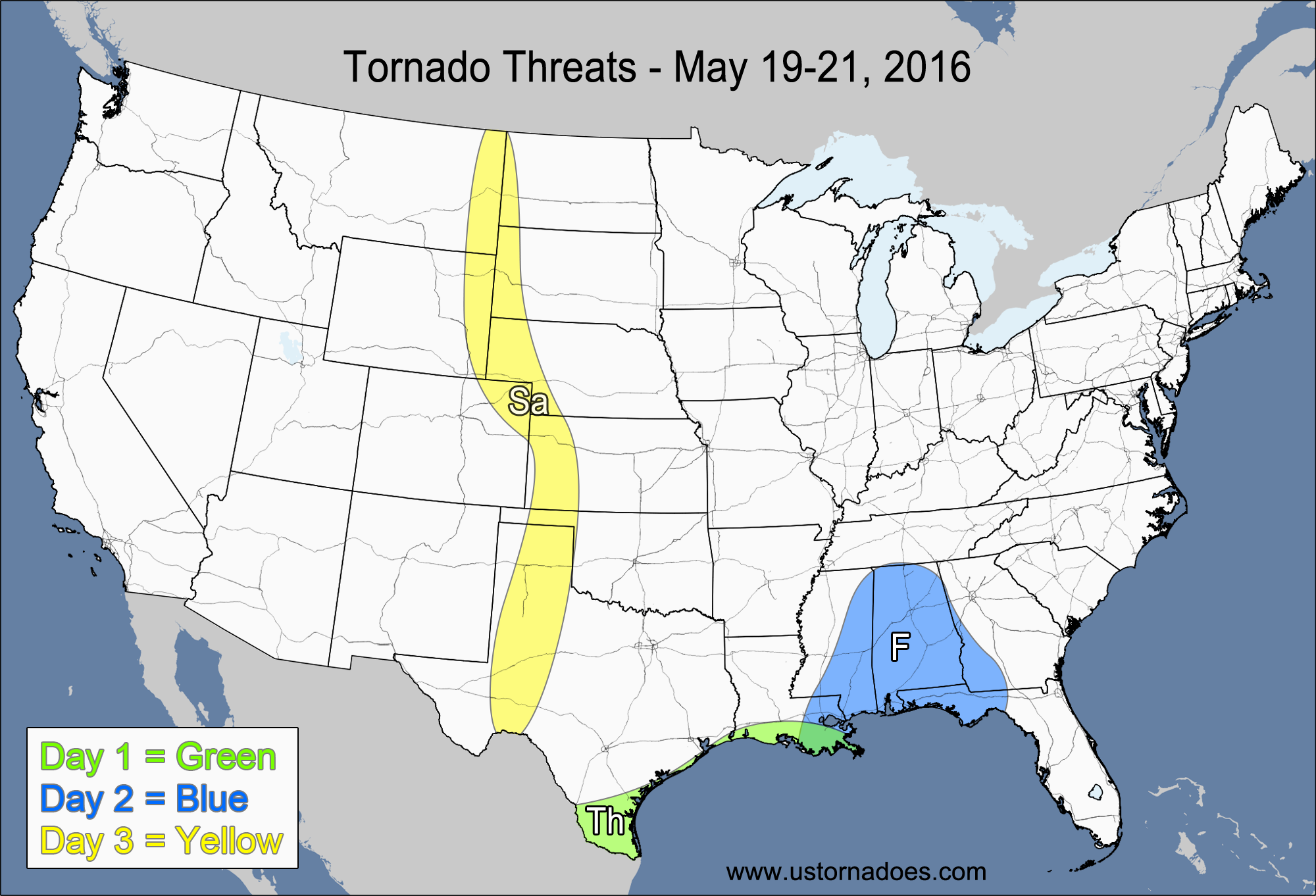
Thursday – Western Gulf Coast
NUMBER OF TORNADOES EXPECTED: 0-2 – CONFIDENCE: High
Tornado Hot-spot: None
Pros: Good low-level directional shear, low to moderate instability, decent mid-to-upper level speed shear.
Cons: Storm mode north of Corpus Christi will generally be a MCS/linear, weak low-level speed shear, weak upper-level dynamics.
Friday – Southeast
NUMBER OF TORNADOES EXPECTED: 0-3 – CONFIDENCE: High
Tornado Hot-spot: None
Pros: Good low-level directional shear, low to moderate instability, decent mid-to-upper level speed shear.
Cons: Weak low-level speed shear, weak/decent upper-level dynamics, morning clouds and rain limiting the instability.
Saturday – High Plains
NUMBER OF TORNADOES EXPECTED: 2-5 – CONFIDENCE: Normal
Tornado Hot-spot: None
Pros: Good/excellent directional shear, decent/good speed shear in the northern High Plains, decent upper-level support in the northern High Plains.
Cons: Limited storm coverage, capping issues, neutral/rising heights in most of the threat area, weak/decent speed shear in the southern and central High Plains, little to no upper-level support in the southern and central High Plains.
4-7 Day
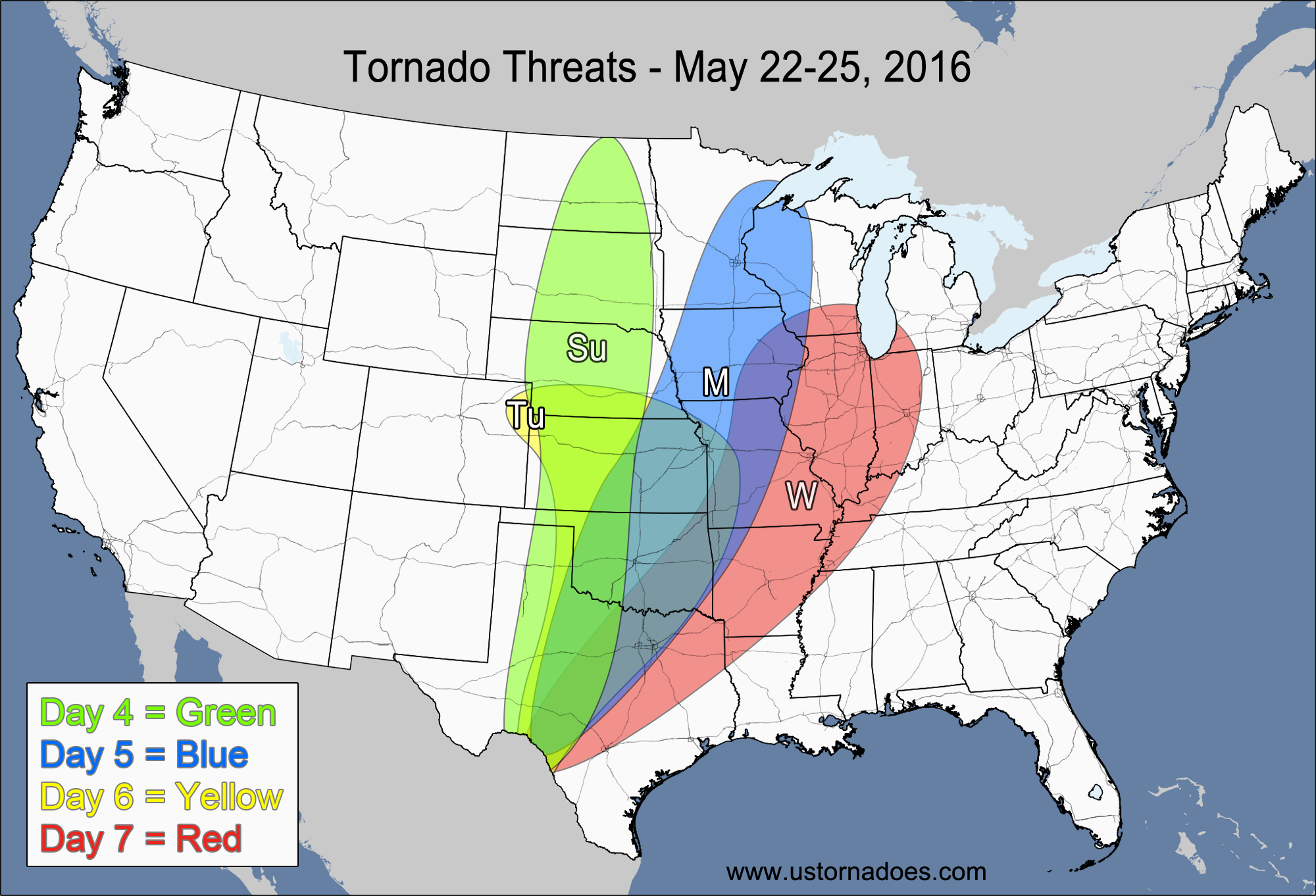
Sunday – Plains
NUMBER OF TORNADOES EXPECTED: 8-20 – CONFIDENCE: Low
Tornado Hot-spot: Northern Plains
Pros: Good directional shear, moderate to high instability, decent/good speed shear, decent upper-level dynamics in the northern Plains.
Cons: Some weakness in the mid-level speed shear, little to no upper-level support in the central and southern Plains, inconsistent storm coverage in the central and southern Plains.
Monday – Southern and east-central Plains, western Midwest
NUMBER OF TORNADOES EXPECTED: 6-16 – CONFIDENCE: Low
Tornado Hot-spot: Kansas, Oklahoma
Pros: Moderate to high instability, decent/good speed shear, good/excellent directional shear in the Plains.
Cons: Weak upper-level support, weak directional shear in the western Midwest, capping issues in Texas.
Tuesday – Central and southern Plains
NUMBER OF TORNADOES EXPECTED: 14-30 – CONFIDENCE: Low
Tornado Hot-spot: Kansas, Oklahoma
Pros: Moderate to high instability, good/excellent directional shear, good speed shear, decent upper-level support.
Cons: Weakness in the mid-level speed shear, capping issues leading to questionable storm coverage in Texas.
Wednesday – Southern Plains, central Mississippi Valley, Midwest
NUMBER OF TORNADOES EXPECTED: 5-13 – CONFIDENCE: Low
Tornado Hot-spot: None
Pros: Moderate to high instability, decent/good directional shear.
Cons: Weak/decent speed shear, capping issues leading to questionable storm coverage in the Plains, weak upper-level dynamics.
Latest posts by Mark Ellinwood (see all)
- Spring 2023 seasonal tornado outlook - March 1, 2023
- Spring 2022 seasonal tornado outlook - March 1, 2022
- Spring 2021 seasonal tornado outlook - March 1, 2021