We’re in for an active tornado period over the next several days, with Friday through Sunday being the main days to watch. There is still uncertainty with how big each day will get, with winds aloft generally going against a higher-end outbreak on any given day. However, we could/should still see multiple days get into double-digit tornado counts.
Just a reminder that the Day 1 forecast only includes tornadoes that happen AFTER the forecast is published. I do not hindcast tornadoes that may have already happened.
1-3 Day
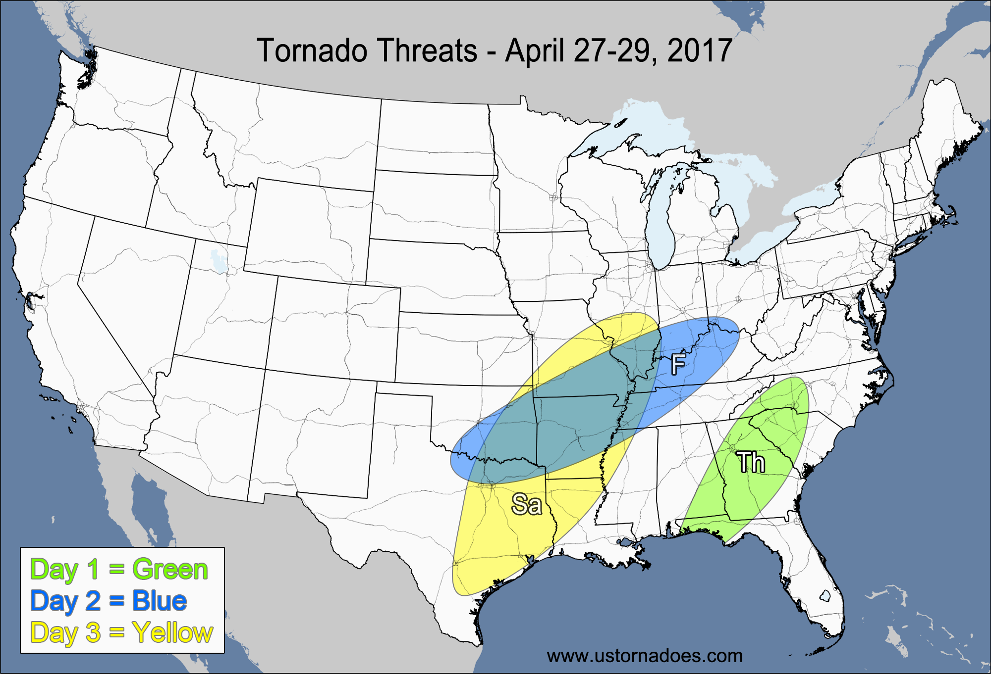
Thursday – Eastern Southeast
NUMBER OF TORNADOES EXPECTED: 1-4 – CONFIDENCE: High
Tornado Hot-spot: Georgia, southeastern Alabama
Pros: Low to moderate instability, good/excellent speed shear, decent low-level directional shear.
Cons: Weak upper-level support, mostly unidirectional winds in the mid-to-upper levels.
Friday – Southeastern Plains, central Mississippi Valley, lower Ohio Valley
NUMBER OF TORNADOES EXPECTED: 8-20 – CONFIDENCE: Normal
Tornado Hot-spot: None
Pros: Moderate to high instability, good/excellent low-level directional shear, good/excellent speed shear.
Cons: Fairly unidirectional winds in the mid-to-upper levels, little to no upper-level support, rising heights in the warm sector causing capping issues.
Saturday – Southeastern Plains, southern and central Mississippi Valley
NUMBER OF TORNADOES EXPECTED: 10-25 – CONFIDENCE: Normal
Tornado Hot-spot: None
Pros: Moderate to high instability, decent/good low-level directional shear, good/excellent speed shear.
Cons: Unidirectional winds in the mid-to-upper levels in conjunction with a surging cold front will make storms go linear quickly.
4-7 Day
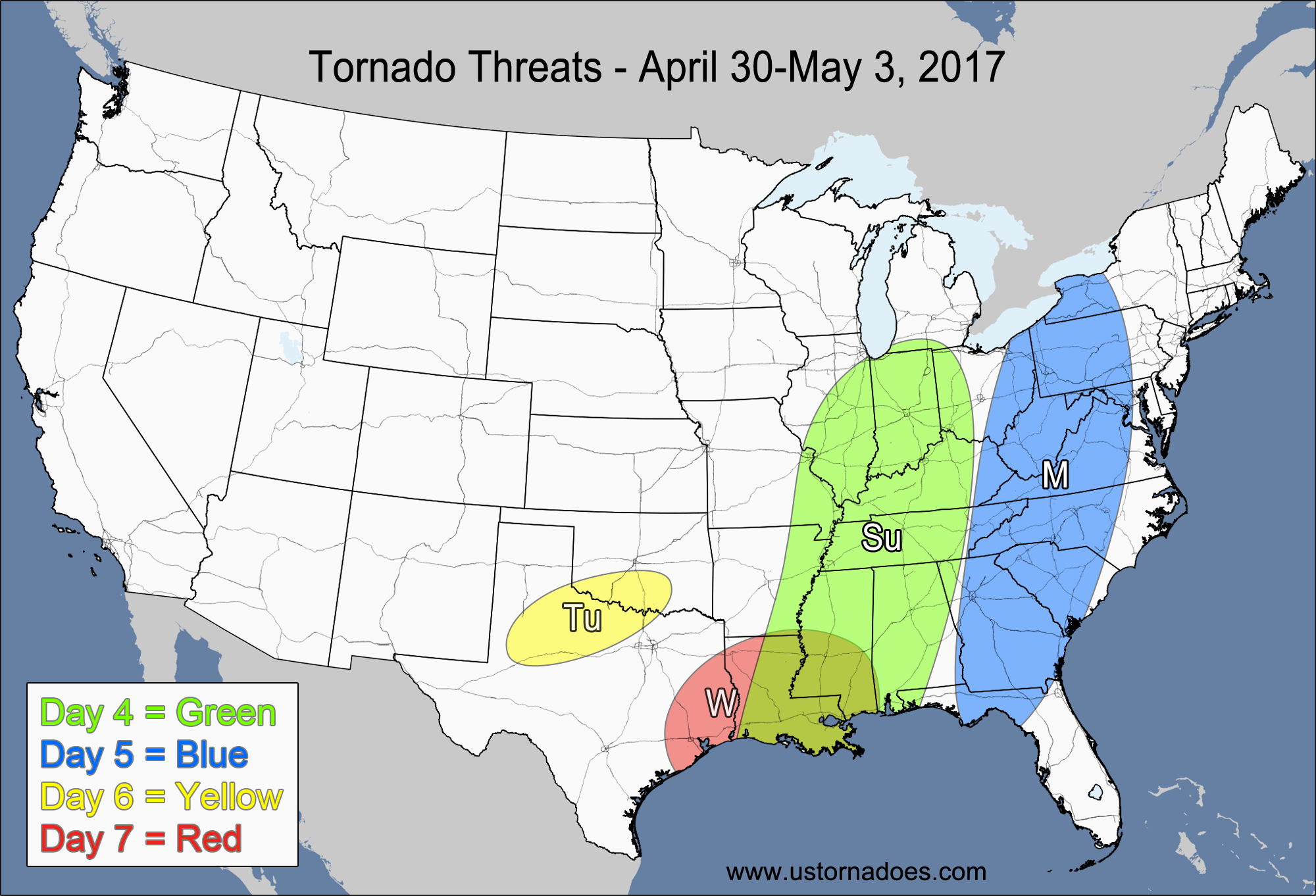
Sunday – Southern Midwest, western Southeast
NUMBER OF TORNADOES EXPECTED: 10-25 – CONFIDENCE: Normal
Tornado Hot-spot: Western Southeast
Pros: Low to moderate instability, good/excellent speed shear, decent/good low-level directional shear.
Cons: Unidirectional/backing winds in the mid-to-upper levels in most areas leading to a more linear storm mode.
Monday – Mid-Atlantic, eastern Southeast
NUMBER OF TORNADOES EXPECTED: 1-4 – CONFIDENCE: Normal
Tornado Hot-spot: None
Pros: Good/excellent speed shear.
Cons: Poor/decent low-level directional shear, low instability, unidirectional winds in the mid-to-upper levels, mostly linear storm mode.
Tuesday – Northern Texas, southern Oklahoma
NUMBER OF TORNADOES EXPECTED: 0-3 – CONFIDENCE: Normal
Tornado Hot-spot: None
Pros: Good/excellent directional shear, good speed shear.
Cons: Low instability, questionable storm coverage, capping concerns.
Wednesday – Eastern Texas, Louisiana, southern Mississippi
NUMBER OF TORNADOES EXPECTED: 2-5 – CONFIDENCE: Low
Tornado Hot-spot: None
Pros: Low to moderate instability, decent/good low-level directional shear, decent/good speed shear.
Cons: Questionable storm organization and mode, poor model agreement with the storm setup, directional shear could be worse than forecast.
Latest posts by Mark Ellinwood (see all)
- Spring 2023 seasonal tornado outlook - March 1, 2023
- Spring 2022 seasonal tornado outlook - March 1, 2022
- Spring 2021 seasonal tornado outlook - March 1, 2021