Aside from today, it looks fairly quiet through the weekend. Then things start to pick up at the start of the work week in the central U.S. Just outside of the forecast period, another storm system could bring a more active period to the Plains late next week, so keep an eye out!
1-3 Day
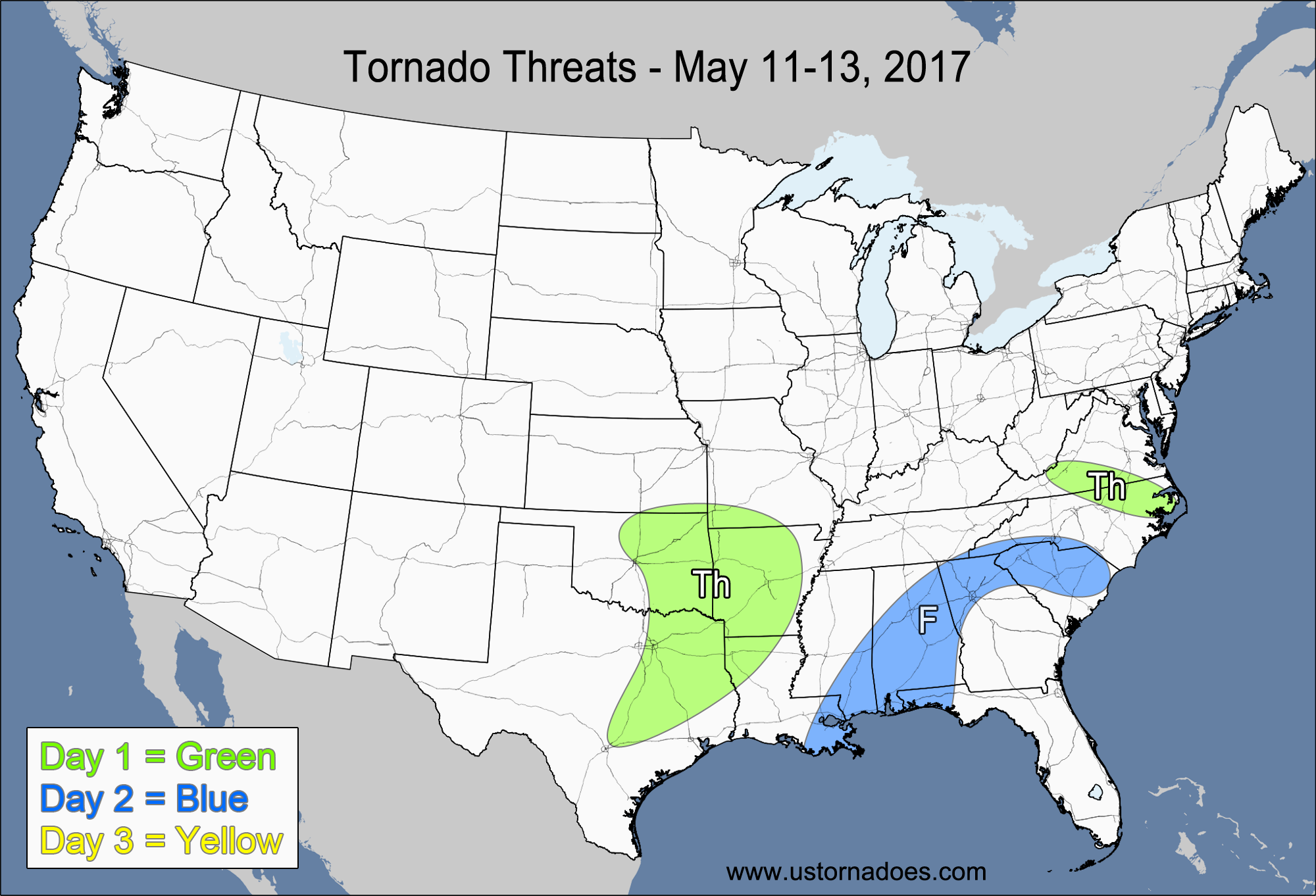
Thursday – Southeastern Plains, southern Mississippi Valley
NUMBER OF TORNADOES EXPECTED: 2-5 – CONFIDENCE: Normal
Tornado Hot-spot: None
Pros: Areas of decent/good low-level directional shear, decent/good speed shear, low to moderate instability, decent/good upper-level support.
Cons: Areas of poor directional shear, fairly unidirectional winds in the mid-to-upper levels, uncertainty with how quickly storms will become more linear.
Thursday – Southern Virginia, northeastern North Carolina
NUMBER OF TORNADOES EXPECTED: 0-2 – CONFIDENCE: High
Tornado Hot-spot: None
Pros: Decent/good low-level directional shear, decent/good speed shear, low to moderate instability.
Cons: Unidirectional winds in the mid-to-upper levels, most storm activity will be north of the warm front, weak mid-to-upper level lapse rates, weak upper-level support.
Friday – Southeast
NUMBER OF TORNADOES EXPECTED: 1-3 – CONFIDENCE: Normal
Tornado Hot-spot: None
Pros: Low to moderate instability, decent upper-level dynamics.
Cons: Poor/decent directional and speed shear.
Saturday
No tornadoes expected.
4-7 Day
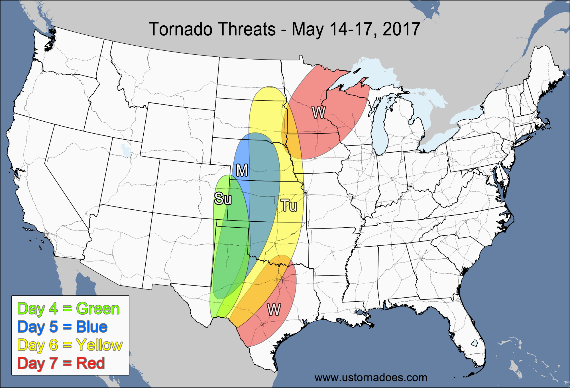
Sunday – Central and southern High Plains
NUMBER OF TORNADOES EXPECTED: 0-2 – CONFIDENCE: Normal
Tornado Hot-spot: None
Pros: Low to moderate instability, good low-level directional shear, decent low-level speed shear.
Cons: Weak mid-to-upper level speed shear in most spots, rising heights, questionable storm coverage.
Monday – Central and southern Plains
NUMBER OF TORNADOES EXPECTED: 3-7 – CONFIDENCE: Low
Tornado Hot-spot: None
Pros: Moderate instability, good directional shear, good low-level speed shear.
Cons: Somewhat-weak mid-level speed shear, unidirectional winds in the mid-to-upper levels, with winds possibly backing in the upper levels, questionable storm coverage.
Tuesday – Plains
NUMBER OF TORNADOES EXPECTED: 6-14 – CONFIDENCE: Low
Tornado Hot-spot: Southern Nebraska, Kansas, Oklahoma
Pros: Good low-level directional shear, good speed shear, moderate to high instability, decent upper-level dynamics.
Cons: Unidirectional winds in the mid-to-upper levels could cause storms to go linear quickly, window for tornadic activity looks to be small as the storms become more elevated in the evening.
Wednesday – Northwestern Midwest
NUMBER OF TORNADOES EXPECTED: 0-3 – CONFIDENCE: Low
Tornado Hot-spot: None
Pros: Moderate instability, good/excellent speed shear, decent/good upper-level support.
Cons: Poor directional shear.
Wednesday – Texas
NUMBER OF TORNADOES EXPECTED: 1-4 – CONFIDENCE: Low
Tornado Hot-spot: None
Pros: Moderate to high instability, good low-level directional shear, good upper-level speed shear.
Cons: Weak low-to-mid level speed shear, unidirectional winds in the mid-to-upper levels, questionable storm mode.
Latest posts by Mark Ellinwood (see all)
- Spring 2023 seasonal tornado outlook - March 1, 2023
- Spring 2022 seasonal tornado outlook - March 1, 2022
- Spring 2021 seasonal tornado outlook - March 1, 2021
Hey guys. Thank you so much for these outlooks. I wish there were more updates posted, but it is very much appreciated. I’m a student in college studying Meteorology. I particularly like your map graphic depicting severe threat areas. I always share with others. + the fact that you guys give details that the everyday person who isn’t too well up on meteorological terminology can understand – just makes it that much better. Thanks again!