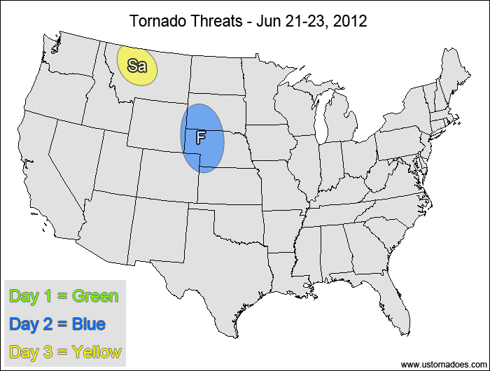
1-3 DAY
No tornadic activity expected.
Friday
Central High Plains — POTENTIAL: Low — CONFIDENCE: Normal
Storms forming in the vicinity of a weak shortwave pulse will be in a strongly-rotational environment with moderate CAPE, but a weak cap, somewhat-anemic mid-level speed shear and height rises will inhibit tornado formation.
Saturday
Montana — POTENTIAL: Low — CONFIDENCE: Normal
As the main upper-level low spins over the Pacific Northwest, strong, rotational shear will combine with an area of low to moderate CAPE to produce isolated supercells. One or more of these supercells may be able to drop a tornado despite potential capping issues.
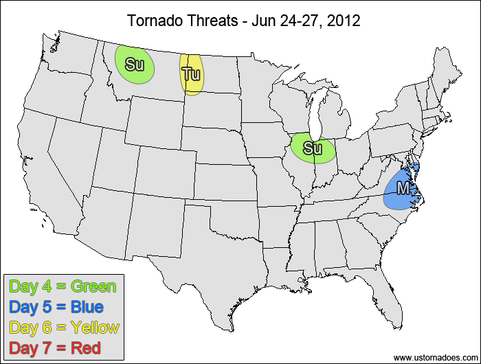
4-7 DAY
Montana — POTENTIAL: Very Low — CONFIDENCE: Normal
Nearly the same setup as Saturday’s threat, only the latest models show less storm coverage on this day as height rises enter the region.
Northern Illinois, northern Indiana — POTENTIAL: Very Low — CONFIDENCE: Normal
Low to moderate CAPE will be available in an atmosphere with weak westerly flow at the surface and moderate strong northwesterly flow aloft, allowing for rotating storms to possibly put down a tornado. The tornado potential will be limited by weak directional shear throughout most of the risk area and weak low/mid-level lapse rates.
Monday
Southern Mid-Atlantic, North Carolina — POTENTIAL: Very Low — CONFIDENCE: Low
Storms forming along/ahead of a cold front are expected to be in an environment with low to moderate CAPE and shear, allowing for some tornadic potential if storms can stay discrete and overcome possible lapse rate issues. Poor model agreement concerning the timing and the risk area will keep confidence low.
Tuesday
Northern High Plains — POTENTIAL: Very Low — CONFIDENCE: Normal
Storms forming in a narrow corridor of favorable CAPE and shear could possibly become tornadic, but capping concerns and storm coverage will also be there to inhibit the overall potential.
Wednesday
No tornadic activity expected.
{ "@context": "https://schema.org", "@type": "Article", "mainEntityOfPage": { "@type": "WebPage", "@id": "https://ustornadoes.com/2026/07/30/claiming-mega-wins-free-spins-deals-for-uk-players/" }, "headline": "Claiming Mega…
Getting Started with Daytonaspin: A Guide for UK Players For players in the United Kingdom…
{ "@context": "https://schema.org", "@type": "Article", "mainEntityOfPage": { "@type": "WebPage", "@id": "https://ustornadoes.com/2026/07/30/pink-lady-casino-registration-in-the-united-kingdom-guide/" }, "headline": "Pink Lady…
Understanding Your Payment Options at Extreme Spins Navigating the financial landscape of an online casino…
Understanding the MySpins Welcome Bonus in the United Kingdom For players in the United Kingdom,…
It's peak tornado season. We briefly examine the top outbreaks from April-June.