Tomorrow is shaping up to be a fairly similar setup to what the eastern U.S. saw back on the 8th, only a bit further south, with stronger low-level winds and more questionable instability. Due to the lower forecast instability, confidence in the forecast is slightly lower than the 8th, which is evident from the SPC’s forecast of a high-end Slight Risk at this lead time, whereas they had hoisted the Moderate Risk at this lead time for the 8th. Below is their Day 1 forecast for the 8th, showing the Moderate Risk along with the verification:
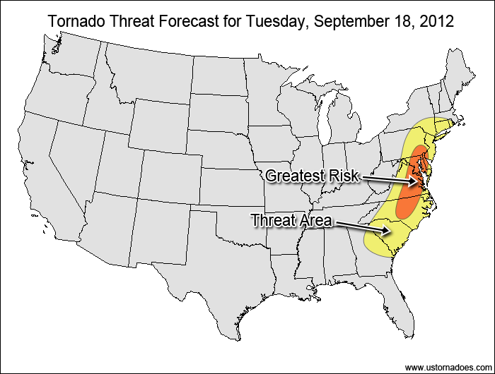
My forecast lines up pretty well with what the SPC has for tomorrow. The greatest tornado threat will extend from central North Carolina up through southeastern PA, where the best combination of wind shear and instability is expected. Right now the models are a bit modest with instability, with the northern parts of the Greatest Risk area reaching 750-1250 J/kg CAPE as southern Virginia into North Carolina has a more respectable 1500-2000+ J/kg maximum. The lack of instability is caused by pre-frontal clouds and rain and somewhat-weak lapse rates, but the models tend to under-forecast the instability in this type of setup, so the instability will have to be closely monitored tomorrow in order to assess the tornado potential.
The Tornado Threat Forecast:
The latest SPC general severe (wind/hail/tornado) forecast:
Despite the lack of instability, this system will have plenty of wind shear and dynamical forcing to spawn tornadoes. The overall risk for tomorrow’s event is a medium (one to several tornadoes) throughout the general risk area, with upside risk if the instability can improve. In addition to pre-frontal storms capable of producing tornadoes, the main squall line along the cold front could have embedded supercell structures. The main threat is in the southern Mid-Atlantic during the afternoon and evening, with a lesser threat extending into southern New England during the overnight hours as the squall line progresses eastward.
I have decided that issuing Tornado Threat Forecasts on an as-needed basis will be better than issuing general weekly reports during the quiet season. Generally, low/very low risk days will not be forecast, but there will be forecasts issued for events where a medium to high tornado potential exists.
It's peak tornado season. We briefly examine the top outbreaks from April-June.
A dip in the jet stream is blasting toward the central United States and poised…
A historic storm system swept through the central, southern and eastern U.S. from Friday through…
In a field historically dominated by men, Jen Walton has emerged as a transformative figure…
Jason Persoff, MD, SFHM, is recognized globally for his expertise in storm chasing. He earned…
Tornado numbers were near or above average. A chase season peak in June provided numerous…
View Comments