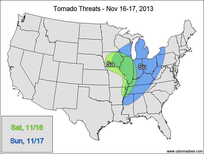
A strong disturbance will work into the Midwest today into tomorrow, with the threat of a tornado outbreak looming on Sunday. As is typical with these cold season threats, this system has a high shear/low CAPE environment with conditional risks to both sides. Regardless of the risks, tomorrow’s setup looks prime for widespread severe winds and some tornadoes.
Central Mississippi Valley — POTENTIAL: Low — CONFIDENCE: Normal
Pros: Strong shear (both directional and speed), left-exit region of an upper-level jet.
Cons: Very little instability, weak lapse rates.
Sunday
Midwest, Tennessee Valley — POTENTIAL: High — CONFIDENCE: Normal
Pros: Very strong speed shear, good directional shear, very strong forcing, improving mid-level lapse rates, surface dewpoints in the 60s, pre-frontal supercells possible.
Cons: Instability could be limited by widespread cloud cover and rain in the warm sector. Storms could turn linear faster, which would limit the supercell potential.
{ "@context": "https://schema.org", "@type": "Article", "mainEntityOfPage": { "@type": "WebPage", "@id": "https://ustornadoes.com/2026/07/30/claiming-mega-wins-free-spins-deals-for-uk-players/" }, "headline": "Claiming Mega…
Getting Started with Daytonaspin: A Guide for UK Players For players in the United Kingdom…
{ "@context": "https://schema.org", "@type": "Article", "mainEntityOfPage": { "@type": "WebPage", "@id": "https://ustornadoes.com/2026/07/30/pink-lady-casino-registration-in-the-united-kingdom-guide/" }, "headline": "Pink Lady…
Understanding Your Payment Options at Extreme Spins Navigating the financial landscape of an online casino…
Understanding the MySpins Welcome Bonus in the United Kingdom For players in the United Kingdom,…
It's peak tornado season. We briefly examine the top outbreaks from April-June.