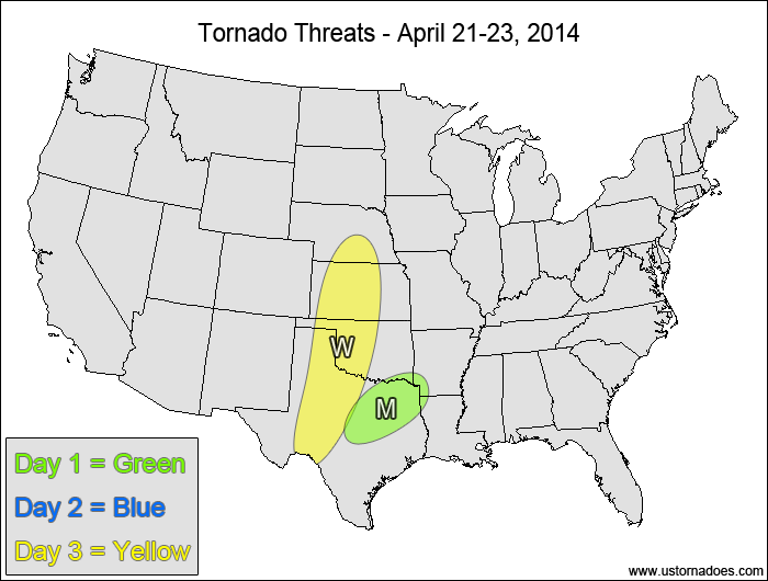
Today we resume regular updates of the Tornado Threat Forecast every Monday and Thursday! As we have done for the past two years, the regular updates will be twice per week until things start getting quiet again in the later parts of summer. There will be a break from these forecasts during our storm chase expedition (or “chasecation”) in the back half of May, at which time daily updates of how our chasecation is progressing will be posted instead.
Northeastern Texas, southeastern Oklahoma southwestern Arkansas — TORNADO RANGE: 0-2 — CONFIDENCE: High
Expected Tornado Hotspot: None
Pros: Moderate instability, decent/good directional shear
Cons: Weak speed shear, winds not that backed at the surface, no strong upper-level dynamics, mediocre mid-level lapse rates
Tuesday
No tornadoes expected.
Wednesday
Central and southern Plains — TORNADO RANGE: 0-2 — CONFIDENCE: Normal
Expected Tornado Hotspot: None
Pros: Strong directional shear, good speed shear, decent upper-level dynamics and height falls
Cons: Low to moderate surface instability, limited moisture leading to very high LCLs
Mid-Mississippi Valley — TORNADO RANGE: 0-1 — CONFIDENCE: Normal
Expected Tornado Hotspot: None
Pros: Good upper-level dynamics, decent/good speed shear
Cons: Low instability, limited directional shear, possible capping issues, mostly linear storm mode due to unidirectional shear aloft
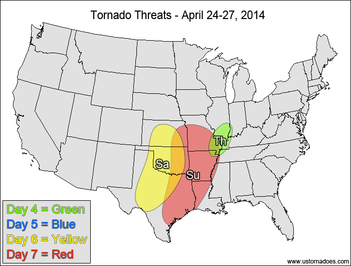
Friday
No tornadoes expected.
Saturday
Southern Plains — TORNADO RANGE: 3-8 — CONFIDENCE: Low
Expected Tornado Hotspot: Oklahoma, southern Kansas
Pros: Moderate/high instability, strong directional shear, good speed shear
Cons: Best upper-level dynamics lag behind storm initiation, upper-level winds becoming more southerly in the overnight hours
Sunday
Southeastern and east-central Plains, southern/mid Mississippi Valley — TORNADO RANGE: 2-6 — CONFIDENCE: Low
Expected Tornado Hotspot: Southeastern Kansas through northeastern Texas
Pros: Decent/good directional shear, good speed shear, strong upper-level dynamics, good storm coverage
Cons: Instability concerns in areas with the best wind profiles, concerns about progression of the system, upper-level flow could be less favorable, surface low could weaken and/or become more strung out
It's peak tornado season. We briefly examine the top outbreaks from April-June.
A dip in the jet stream is blasting toward the central United States and poised…
A historic storm system swept through the central, southern and eastern U.S. from Friday through…
In a field historically dominated by men, Jen Walton has emerged as a transformative figure…
Jason Persoff, MD, SFHM, is recognized globally for his expertise in storm chasing. He earned…
Tornado numbers were near or above average. A chase season peak in June provided numerous…