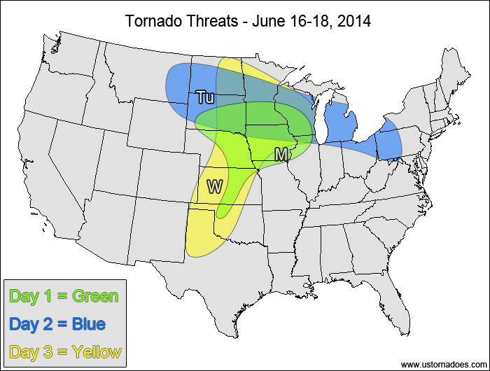
Looks like an active day shaping up across portions of Nebraska, South Dakota, Iowa and Minnesota today! PDS Tornado Watch already up in northern Nebraska.
Programming note: I will not be able to do an update this Thursday, so an update will be posted on Friday instead.
Central Plains, western Midwest — TORNADO RANGE: 5-12 — CONFIDENCE: Normal
Expected Tornado Hotspot: Eastern Nebraska, southeastern South Dakota, Iowa
Pros: Good/strong speed and directional shear, moderate to high instability, possible enhancement through boundary interaction
Cons: Storm initiation/coverage of discrete storm concerns, possible quick transition to a MCS, lackluster upper-level forcing
Tuesday
Northern Plains, northern Midwest, northwestern Mid-Atlantic — TORNADO RANGE: 2-6 — CONFIDENCE: Normal
Expected Tornado Hotspot: Northern Plains
Pros: Decent/good directional shear, moderate to high instability, good upper-level forcing in the northern High Plains
Cons: No appreciable upper-level forcing east of the Plains, SW/WSW flow in most of the Midwest, capping concerns
Wednesday
Plains, northwestern Midwest — TORNADO RANGE: 1-4 — CONFIDENCE: Normal
Expected Tornado Hotspot: None
Pros: Decent/good directional shear in the Midwest, decent/good upper-level forcing in the northern Plains, moderate to high instability
Cons: Backing wind in the upper-levels in the Plains
Central and northeastern Plains, western Midwest — TORNADO RANGE: 1-4 — CONFIDENCE: Normal
Expected Tornado Hotspot: None
Pros: Decent/good speed and directional shear, moderate to high instability
Cons: Mid-level speed shear is somewhat weak in spots, no appreciable upper-level forcing
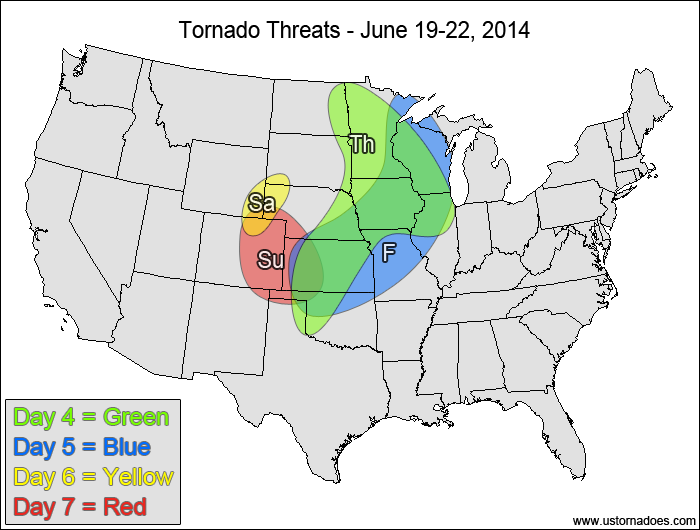
Friday
Central Plains, western Midwest — TORNADO RANGE: 0-3 — CONFIDENCE: Normal
Expected Tornado Hotspot: None
Pros: Decent/good directional shear, moderate to high instability
Cons: fairly weak speed shear in the mid to upper levels
Saturday
Central High Plains — TORNADO RANGE: 0-2 — CONFIDENCE: Normal
Expected Tornado Hotspot: None
Pros: Some upslope, low to moderate instability
Cons: Weak speed shear
Sunday
Central High Plains — TORNADO RANGE: 0-3 — CONFIDENCE: Normal
Expected Tornado Hotspot: None
Pros: Decent/good upslope flow, moderate instability
Cons: Somewhat weak speed shear in the mid to upper levels
{ "@context": "https://schema.org", "@type": "Article", "mainEntityOfPage": { "@type": "WebPage", "@id": "https://ustornadoes.com/2026/07/30/claiming-mega-wins-free-spins-deals-for-uk-players/" }, "headline": "Claiming Mega…
Getting Started with Daytonaspin: A Guide for UK Players For players in the United Kingdom…
{ "@context": "https://schema.org", "@type": "Article", "mainEntityOfPage": { "@type": "WebPage", "@id": "https://ustornadoes.com/2026/07/30/pink-lady-casino-registration-in-the-united-kingdom-guide/" }, "headline": "Pink Lady…
Understanding Your Payment Options at Extreme Spins Navigating the financial landscape of an online casino…
Understanding the MySpins Welcome Bonus in the United Kingdom For players in the United Kingdom,…
It's peak tornado season. We briefly examine the top outbreaks from April-June.