Climatologically-favored areas edition. Lots of threats on the High Plains and up in the northern Plains and northwestern Midwest in the coming week.
Programming Note: Starting next week, I will have a new job that involves rotating shifts, so consistent mid to late afternoon posts may be hard to come by going forward. Just going to have to go with the flow!
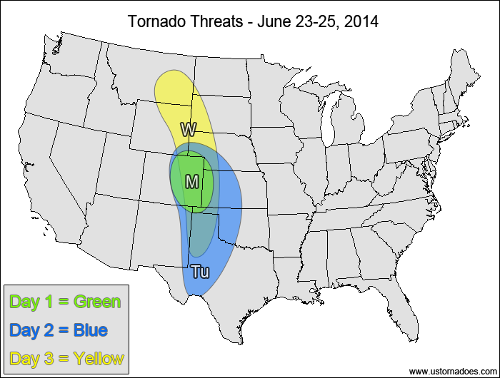
Central High Plains — TORNADO RANGE: 1-3 — CONFIDENCE: Normal
Expected Tornado Hotspot: None
Pros: Strong directional shear, decent/good speed shear, low to moderate instability
Cons: Lack of upper-level forcing, questionable storm mode, somewhat-weak low-level speed shear
Tuesday
Central and southern Plains — TORNADO RANGE: 2-7 — CONFIDENCE: Normal
Expected Tornado Hotspot: None
Pros: Good/strong directional shear, decent speed shear aloft, moderate instability
Cons: Weak upper-level forcing, somewhat-weak low-level speed shear
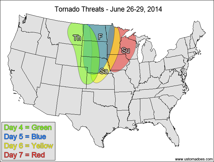
Wednesday
High Plains — TORNADO RANGE: 2-6 — CONFIDENCE: Normal
Expected Tornado Hotspot: None
Pros: Good/strong directional shear
Cons: High LCLs, fairly weak speed shear in the mid-levels, still no appreciable upper-level forcing
Northern and central Plains — TORNADO RANGE: 1-5 — CONFIDENCE: Normal
Expected Tornado Hotspot: Northern High Plains
Pros: Moderate to high instability, good/strong directional shear
Cons: Weak low/mid-level speed shear, upper-level forcing still too displaced to the west to have much of an impact, high LCLs in most areas
Friday
Northern and central Plains — TORNADO RANGE: 2-6 — CONFIDENCE: Low
Expected Tornado Hotspot: Dakotas
Pros: High instability, decent/good directional shear, 500mb trough starting to work into the target area
Cons: Capping concerns in the southern areas, some speed shear concerns remain, some areas might have backing winds in the mid to upper-levels
Saturday
Northern and central Plains, northwestern Midwest — TORNADO RANGE: 2-6 — CONFIDENCE: Low
Expected Tornado Hotspot: None
Pros: Moderate to high instability, decent upper-level forcing
Cons: More unidirectional flow aloft, capping concerns in the warm sector, storm mode concerns as cold front advances
Sunday
Northwestern Midwest — TORNADO RANGE: 0-4 — CONFIDENCE: Low
Expected Tornado Hotspot: None
Pros: Moderate to high instability, decent/good speed shear, decent/good upper-level forcing
Cons: Weak/decent directional shear, questionable storm mode, advancing cold front, surface low displaced well to the north
{ "@context": "https://schema.org", "@type": "Article", "mainEntityOfPage": { "@type": "WebPage", "@id": "https://ustornadoes.com/2026/07/30/claiming-mega-wins-free-spins-deals-for-uk-players/" }, "headline": "Claiming Mega…
Getting Started with Daytonaspin: A Guide for UK Players For players in the United Kingdom…
{ "@context": "https://schema.org", "@type": "Article", "mainEntityOfPage": { "@type": "WebPage", "@id": "https://ustornadoes.com/2026/07/30/pink-lady-casino-registration-in-the-united-kingdom-guide/" }, "headline": "Pink Lady…
Understanding Your Payment Options at Extreme Spins Navigating the financial landscape of an online casino…
Understanding the MySpins Welcome Bonus in the United Kingdom For players in the United Kingdom,…
It's peak tornado season. We briefly examine the top outbreaks from April-June.