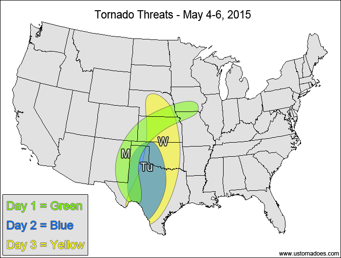
All eyes are on the central and southern Plains this week as multiple storm systems light up the region with severe and tornadic storms. Wednesday and Saturday show the greatest tornado potential, but the week as a whole also looks fairly active.
Central Plains, southern High Plains — TORNADO RANGE: 1-4 — CONFIDENCE: Normal
Expected Tornado Hotspot: Southern High Plains
Pros: Good directional shear, moderate instability, good storm coverage.
Cons: Fairly weak mid-to-upper level speed shear for most of the risk area, no major forcing mechanism, weak upper-level lapse rates.
Tuesday
Southern Plains — TORNADO RANGE: 2-6 — CONFIDENCE: Normal
Expected Tornado Hotspot: None
Pros: Good low-level shear, low to moderate instability, some upper-level forcing.
Cons: Issues with backing winds in the mid-to-upper levels, lackluster mid-level speed shear, early clouds and rain could lower the instability.
Wednesday
Central and southern Plains — TORNADO RANGE: 6-16 — CONFIDENCE: Normal
Expected Tornado Hotspot: Central Plains
Pros: Good/excellent low-level directional shear, moderate instability, decent upper-level forcing in the central Plains.
Cons: Potential issues with backing winds in the upper levels, little or no upper-level forcing in the southern Plains, lackluster speed shear in the mid-to-upper levels.
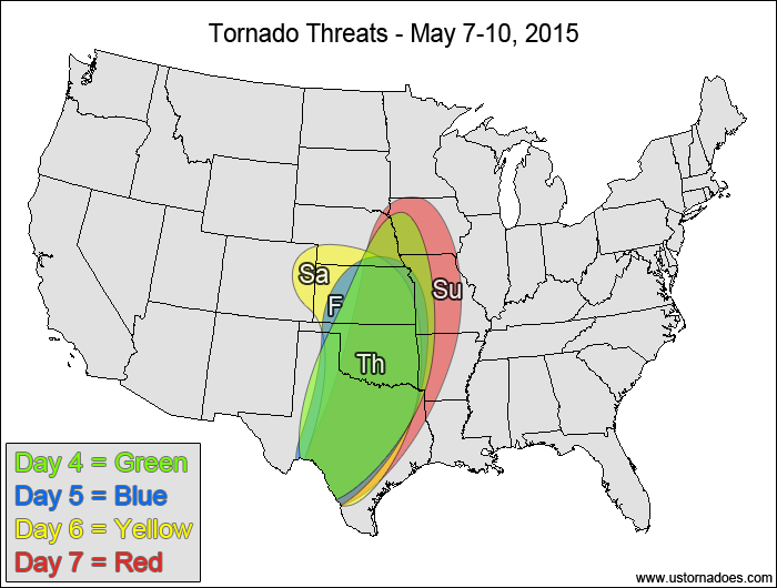
Central and southern Plains — TORNADO RANGE: 3-8 — CONFIDENCE: Normal
Expected Tornado Hotspot: None
Pros: Moderate instability, good low-level shear.
Cons: Fairly weak mid-level speed shear, potential issues with backing winds in the mid-to-upper levels, early clouds and rain in the northernmost parts of the risk area.
Friday
Central and southern Plains — TORNADO RANGE: 3-8 — CONFIDENCE: Low
Expected Tornado Hotspot: None
Pros: Good directional shear, moderate instability.
Cons: Weak mid-level speed shear, lackluster upper-level forcing
Saturday
Central and southern Plains — TORNADO RANGE: 8-20 — CONFIDENCE: Normal
Expected Tornado Hotspot: Central Plains
Pros: Moderate to high instability, good upper-level forcing, good directional shear.
Cons: Potential issues with subtle backing winds in the mid-to-upper levels, mid-level speed shear is a little weak in some spots.
Sunday
East-central and southern Plains, western Midwest — TORNADO RANGE: 4-10 — CONFIDENCE: Low
Expected Tornado Hotspot: East-central Plains, western Midwest
Pros: Low to moderate instability, good directional shear near the surface low, decent/good speed shear, decent/good upper-level forcing.
Cons: Meager directional shear away from the surface low, messy storm mode across the southern Plains, potential issues with backing winds in the mid-to-upper levels.
{ "@context": "https://schema.org", "@type": "Article", "mainEntityOfPage": { "@type": "WebPage", "@id": "https://ustornadoes.com/2026/07/30/claiming-mega-wins-free-spins-deals-for-uk-players/" }, "headline": "Claiming Mega…
Getting Started with Daytonaspin: A Guide for UK Players For players in the United Kingdom…
{ "@context": "https://schema.org", "@type": "Article", "mainEntityOfPage": { "@type": "WebPage", "@id": "https://ustornadoes.com/2026/07/30/pink-lady-casino-registration-in-the-united-kingdom-guide/" }, "headline": "Pink Lady…
Understanding Your Payment Options at Extreme Spins Navigating the financial landscape of an online casino…
Understanding the MySpins Welcome Bonus in the United Kingdom For players in the United Kingdom,…
It's peak tornado season. We briefly examine the top outbreaks from April-June.