We’re going to try out this new chase forecast and see how it goes. We’ll probably end up focusing on the bigger potential days, but stay tuned to see how this idea shakes out!
The ingredients are coming together for a significant severe weather event across the Plains as a trough of low pressure swings out of the Rockies, unstable air surges northward across the central states and a surface low pressure system develops over Kansas. This event has the potential to produce a number of tornadoes and perhaps a few strong, longer-lived ones. A few clusters of potentially tornadic storms seem more likely with this somewhat complex setup.
Tornado Threat Forecast: April 25-May 1, 2016
Chase target A:
Northern Kansas
Focusing on the triple point
Possible tornado hot-spot: North-central into northeast Kansas
Pros: More sharply backed low-level winds, stronger forcing, closer to the nose of the upper level jet, high likelihood of supercell thunderstorm development.
Cons: Unidirectional winds from the mid-levels on up, storm mergers expected, leading to a messy storm mode with time.
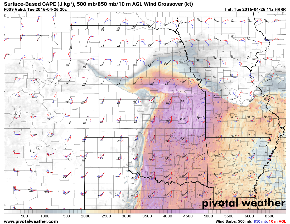
As low pressure occludes over north-central Kansas, a tongue of strong to extreme instability is likely in the narrowing warm sector, as CAPE values may locally exceed 4,000 J/kg. Wind shear and forcing will be maximized near the triple point, where the dry line (just ahead of a cold front), warm front and occluded front meet. This is a classic tornado chase target, but not without a few cautionary flags. With storms expected to be numerous here, they may merge with other cells, causing a messy chase situation. Another interesting consideration is that unlike the more “typical” west to east moving storms, supercells in this vicinity will move in more of a south to north direction. A few tornadic supercells will also be possible eastward along the warm front into northeastern Kansas, but the greatest tornado threat will remain with the cells closest to the triple point. This localized tornado threat will start in northern Kansas by late afternoon and may nudge into far southern Nebraska during the evening.
Chase target B:
North Texas to southern Oklahoma
Playing the southern target
Possible tornado hotspot: Northwest Texas to south-central Oklahoma (mainly west of I-35)
Pros: Better directional shear than farther north along the dryline, isolated storm mode expected, resulting in supercells, glancing influence by a secondary vorticity perturbation.
Cons: Limited low-level shear, a veer-back signature in the mid to upper levels, storm mode could quickly turn messy.
A north-south oriented dry line will sharpen from western Oklahoma into northwest Texas this afternoon. Robust instability will be prevalent in a broad swath ahead of the dry line. Given the orientation and timing of the upper level trough, there is a veer-back-veer signature in the forecast soundings, which may work to interfere with supercell structure. There may be a tendency for cells to trend toward a linear mode with time, perhaps quickly, although at least a narrow window for tornadoes should exist.
Chase target C:
Central Kansas to western/central Oklahoma
Targeting the dry line
Possible tornado hotspot: Just west of the I-35 corridor in Oklahoma
Pros: Storm mode more isolated, favoring supercells. Any storms that do fire could become particularly intense, if they remain isolated.
Cons: Poor directional shear, messy wind profiles, storm coverage is questionable in south-central Kansas, possible issues with traffic and urban areas (Oklahoma City, Wichita) should storms reach I-35.
The central to northern portion of the dry line will shift east across central Kansas and western Oklahoma during the afternoon. A narrow corridor of strong to extreme instability is likely on the immediate east side of the dry line. Although the thermodynamic environment will be highly supportive of intense thunderstorm development ahead of the dry line, the wind fields look less than ideal for a tornado outbreak. There is a veer-back signature in the forecast soundings, which may limit the tornado potential. There is also the issue with not only chaser convergence in Oklahoma (where many chasers are based), but potential proximity to both Oklahoma City and Wichita. It is never a good idea to chase close to a metro area, especially during a severe weather outbreak.
All of these targets have pros and cons and it will ultimately be up to the chaser to decide which is best. Although tornadoes are expected today, the window of opportunity for chasing may be somewhat limited due to issues with the wind fields. There are other factors to consider including how long a drive it may be to a particular area, and deciding if a chaser will be out in the field as well on Wednesday. Where a chaser ends up Tuesday night will influence where they will have the ability to get to in time for Wednesday’s chase.
{ "@context": "https://schema.org", "@type": "Article", "mainEntityOfPage": { "@type": "WebPage", "@id": "https://ustornadoes.com/2026/07/30/claiming-mega-wins-free-spins-deals-for-uk-players/" }, "headline": "Claiming Mega…
Getting Started with Daytonaspin: A Guide for UK Players For players in the United Kingdom…
{ "@context": "https://schema.org", "@type": "Article", "mainEntityOfPage": { "@type": "WebPage", "@id": "https://ustornadoes.com/2026/07/30/pink-lady-casino-registration-in-the-united-kingdom-guide/" }, "headline": "Pink Lady…
Understanding Your Payment Options at Extreme Spins Navigating the financial landscape of an online casino…
Understanding the MySpins Welcome Bonus in the United Kingdom For players in the United Kingdom,…
It's peak tornado season. We briefly examine the top outbreaks from April-June.
View Comments
I love this format. Brilliant. Definitely do this again. Great work and very insightful.
Excellent info. Look forward to following these over the coming weeks. I'm watching the central KS-OK border...
Great info! Greetz from Belgium