New graphics have been give. Many thanks to Ian for providing me with the new map and overlay!
Some stuff’s going to go down this week in the Plains and Mississippi Valley. Hold on to your butts.
1-3 Day
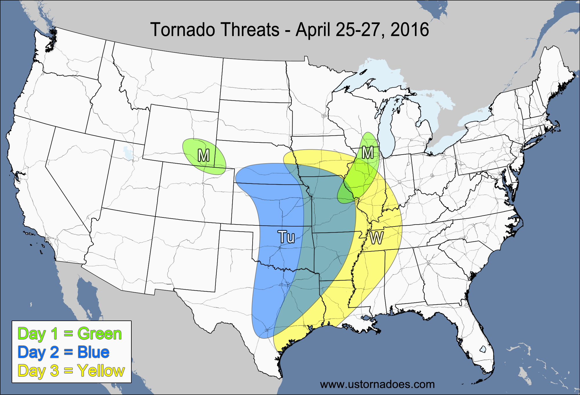
Monday – Northern High Plains
NUMBER OF TORNADOES EXPECTED: 0-2 – CONFIDENCE: High
Tornado Hot-spot: None
Pros: Excellent directional shear, good speed shear, good upper-level dynamics.
Cons: Low instability, limited moisture with surface dew-points in the 40s.
Monday – Western Midwest
NUMBER OF TORNADOES EXPECTED: 0-2 – CONFIDENCE: High
Tornado Hot-spot: None
Pros: Moderate instability, good speed shear.
Cons: Poor directional shear, separation from the upper-level support, the front that is generating the storms is weakening.
Tuesday – Central and southern Plains, central Mississippi Valley
NUMBER OF TORNADOES EXPECTED: 15-35 – CONFIDENCE: Normal
Tornado Hot-spot: Southern Nebraska, central and eastern Kansas, central and eastern Oklahoma
Pros: Good/excellent low-level directional shear, good speed shear, moderate to high instability, decent/good surface low, good upper-level dynamics.
Cons: Capping concerns in Texas, NAM shows capping concerns all the way up to Kansas, upper-level flow is unidirectional, subtle backing winds in the mid-levels in Oklahoma and Texas, speed shear is much weaker in the central Mississippi Valley.
Wednesday – Central and southern Mississippi Valley, far eastern Plains
NUMBER OF TORNADOES EXPECTED: 6-16 – CONFIDENCE: Normal
Tornado Hot-spot: None
Pros: Good speed shear, decent/good directional shear, moderate to high instability, decent upper-level dynamics.
Cons: Storm system is starting to become less organized, unidirectional shear and perhaps some areas of backing winds in the mid-to-upper levels, storms start to out-run the best dynamics, clouds and convective debris from Tuesday’s storms.
4-7 Day
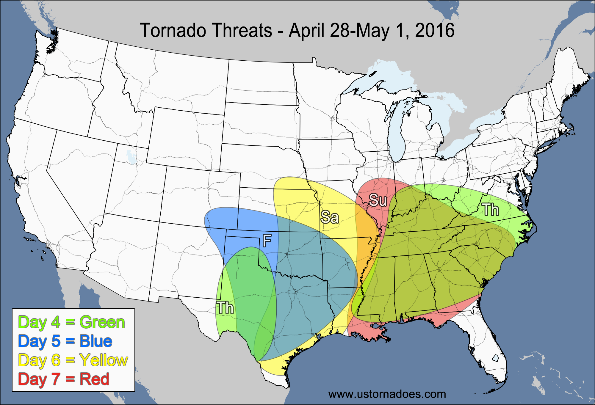
Thursday – Southwestern Plains
NUMBER OF TORNADOES EXPECTED: 1-4 – CONFIDENCE: Normal
Tornado Hot-spot: None
Pros: Good directional shear, decent speed shear, moderate instability.
Cons: No upper-level support, questionable storm coverage.
Thursday – Ohio Valley, Southeast
NUMBER OF TORNADOES EXPECTED: 2-6 – CONFIDENCE: Normal
Tornado Hot-spot: None
Pros: Low to moderate instability, decent/good speed shear.
Cons: Poor/decent directional shear, very little upper-level support, poor/decent mid-level lapse rates in most spots, clouds and convective debris from Wednesday’s storms.
Friday – South-central U.S.
NUMBER OF TORNADOES EXPECTED: 6-16 – CONFIDENCE: Low
Tornado Hot-spot: None
Pros: Good low-level directional shear, good speed shear, low to moderate instability, decent upper-level dynamics.
Cons: Unidirectional winds in the mid-to-upper levels, morning convection could limit instability, concerns with how much instability works into the northern part of the risk area.
Saturday – East-central and southeastern Plains, central and southern Mississippi Valley
NUMBER OF TORNADOES EXPECTED: 6-16 – CONFIDENCE: Low
Tornado Hot-spot: None
Pros: Good low-level directional shear, decent/good speed shear, decent upper-level dynamics.
Cons: Wind in the mid-to-upper levels are unidirectional and even slightly backed
Sunday – Southern Midwest, Southeast
NUMBER OF TORNADOES EXPECTED: 1-4 – CONFIDENCE: Normal
Tornado Hot-spot: None
Pros: Decent/good speed shear, decent/good directional shear in the southern Southeast.
Cons: Low instability across the northern parts of the risk area, weak directional shear, poor mid-level lapse rates, fairly weak/disorganized dynamics.
Latest posts by Mark Ellinwood (see all)
- Spring 2023 seasonal tornado outlook - March 1, 2023
- Spring 2022 seasonal tornado outlook - March 1, 2022
- Spring 2021 seasonal tornado outlook - March 1, 2021