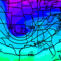
I just wanted to give a quick update on the tornado threat beginning overnight tonight and continuing through Wednesday evening in the Carolinas. First, looking at the 25/0300 UTC sfc observations, you can see the warm front located along the Gulf Coast, with 65-68°F dewpoints located south of it.
Figure 1: 25/0300 UTC sfc plots.
Most of the thinking from last night’s detailed post and Mark’s tornado threat forecast remains intact. The only difference of any significance is the projected track of the sfc low, which has been slowly shifting a bit southward the past few runs. Ultimately, this is not good news. Yes, this does limit the northward extent of the threat, especially earlier in the event (after which the low tends to propagate more northeasterly, expanding the warm sector and tornado threat northward). But, more importantly, it increases the isallobaric component of the wind, the component of the sfc wind attributed to sfc pressure falls and rises, thus keeping winds more backed (southeasterly) at the sfc and increasing low-level shear. The effects of this can be seen in the sharp enlarging of model output hodographs and a rise in 0-1km EHI (energy-helicity index, a scale used to quantify the combined effects of instability and shear) in the 00z GFS and NAM runs.
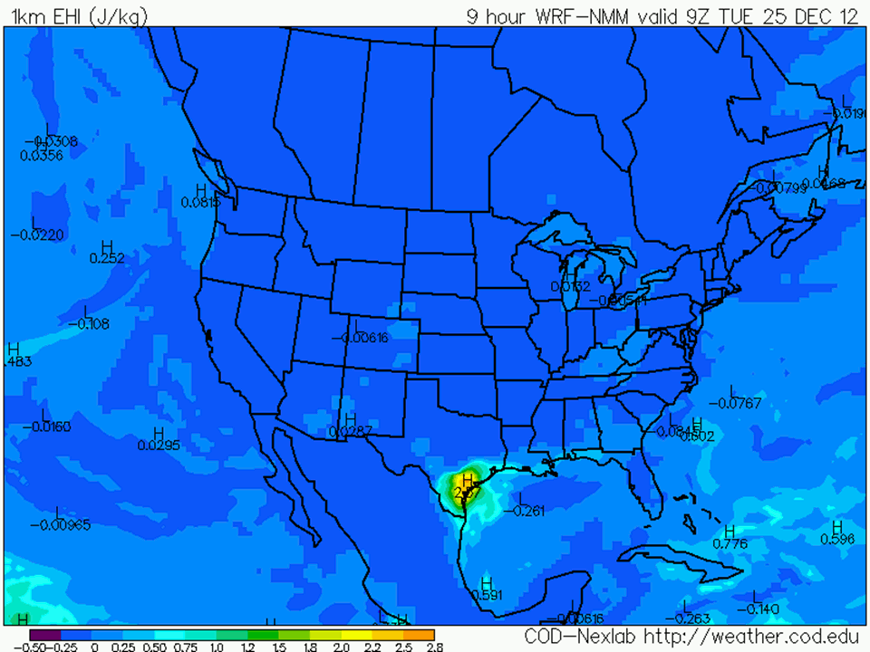
Figure 2: 25/0900 UTC to 27/0000 UTC NAM 0-1km EHI output.
Bottom line
If there has been any trend today, it has been to actually increase the threat slightly, especially for tomorrow. The overall threat may have shifted slightly south, at least in the western portion of the to-be-affected areas. The areas at greatest threat are Louisiana, southern and eastern Mississippi, most of Alabama, and then into Georgia and the Carolinas for Wednesday. Several long-tracked, damaging tornadoes are likely to occur in this area, along with potentially widespread wind damage with a squall line associated with the cold front. If you have loved ones in this area, they need to be aware that this threat exists and that it may manifest in multiple rounds of storms for any given area. Many areas will be under threat after dark, so having a way to get weather warnings while asleep will be crucial.
TL
Related posts
Breaking Down the Christmas Tornado Threat: Un-merry Mayhem
Tornado Threat Forecast: Dec 24-26, 2012
Christmas Eve and Christmas Day tornado history
Tony Lyza
Latest posts by Tony Lyza (see all)
- 2014’s EF3+ tornado drought: The latest in the year on record without one - April 8, 2014
- Tornado Damage Surveys and Ratings: Why Pictures Don’t Tell the Whole Story - February 19, 2013
- Quick Update: Tornado Outbreak Likely Christmas Morning through the 26th - December 24, 2012