“Tornadoes don’t happen in mountains.”
Have you ever heard this statement? It is a common sentiment shared by many. It is true that tornadoes are less common at higher elevations and mountainous terrain, but this does not mean that these landscapes are immune.
This article discusses the influence of mountainous terrain on tornadogenesis and distribution, discusses geographical patterns of tornadoes for four major mountain ranges of the contiguous United States, and provides examples of confirmed tornadoes that have occurred at high elevations.
Why are tornadoes less common over mountainous terrain?
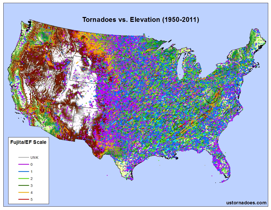
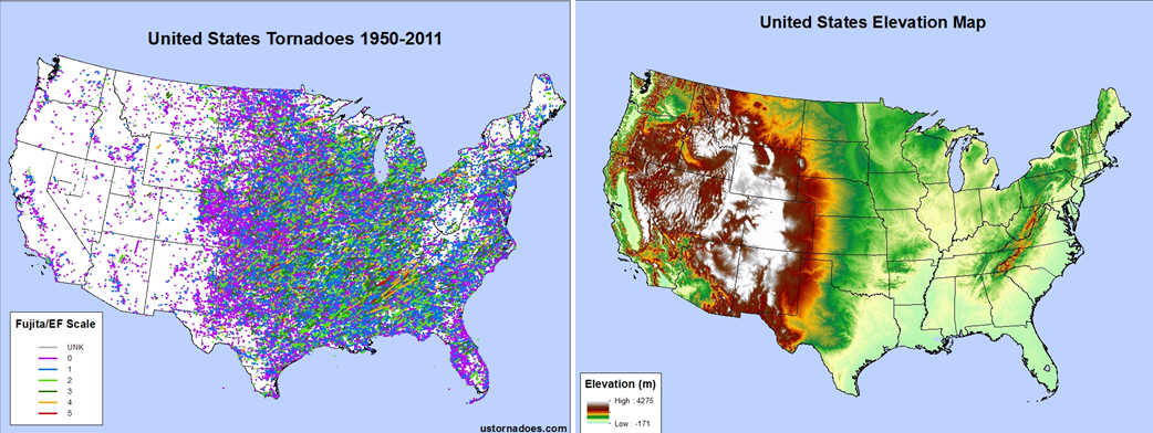
Take a look at the maps below. The first map shows all tornado reports courtesy of the Storm Prediction Center from 1950-2011, and the second map shows elevation (in meters) across the continental United States. Notice the gaps in tornado coverage coincide with the large mountain ranges. The Appalachian Mountains are clearly evident, especially over West Virginia, and the Rocky Mountains provide a nice sharp western edge to the tornado reports found across the Great Plains.
So why are tornadoes less common at higher elevations? The basic answer is simple: higher elevations typically have cooler, more stable air.
A ripe tornado environment features warm and humid “unstable” air to provide energy for the explosive thunderstorms capable of producing thunderstorms. The golden rule when talking about higher elevations is, “the higher you go, the colder it gets.” This is true simply due to environmental lapse rates, or the change in temperature with height.
All things being equal, for every thousand feet gained in elevation there is roughly a 3°F drop in temperature. Colder air at the surface is inherently more stable, and thus colder high elevation landscapes are more stable.
Geographical patterns of tornado reports and the major mountain ranges
The Appalachian Mountains
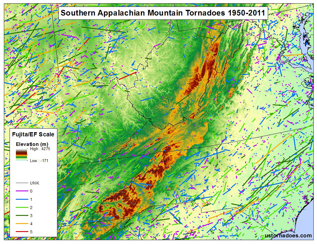
The Appalachian Mountains are the oldest mountains in the continental United States at approximately 480 million years. Due to their age, they are also the lowest elevation mountains from years of erosion, with average elevations of 3,000-6,000ft.
The Appalachian Mountains are directly in the path of storm systems that move from west to east. When these storm systems hit the mountainous terrain, they often weaken or break down then redevelop to the east on the lee-side of the mountain range. Looking at the map above, the gap in tornado coverage is obvious, especially through West Virginia.
Despite the lack of tornado reports, there have been a number of tornadoes in this region, including a mile-wide tornado that struck Roanoke, Virginia in April 1974, an EF3 tornado at 2,080 feet over Glade Spring, Virginia in April 2011, and a weak tornado that struck Mt. Rogers National Park at nearly 4,000 feet also in April 2011. (note: If you’re interested in learning more about Appalachian Mountain tornadoes, you can review my master’s research which investigated multiple tornado events across a small portion of the southern Appalachians in southwestern Virginia.)
The Rocky Mountains
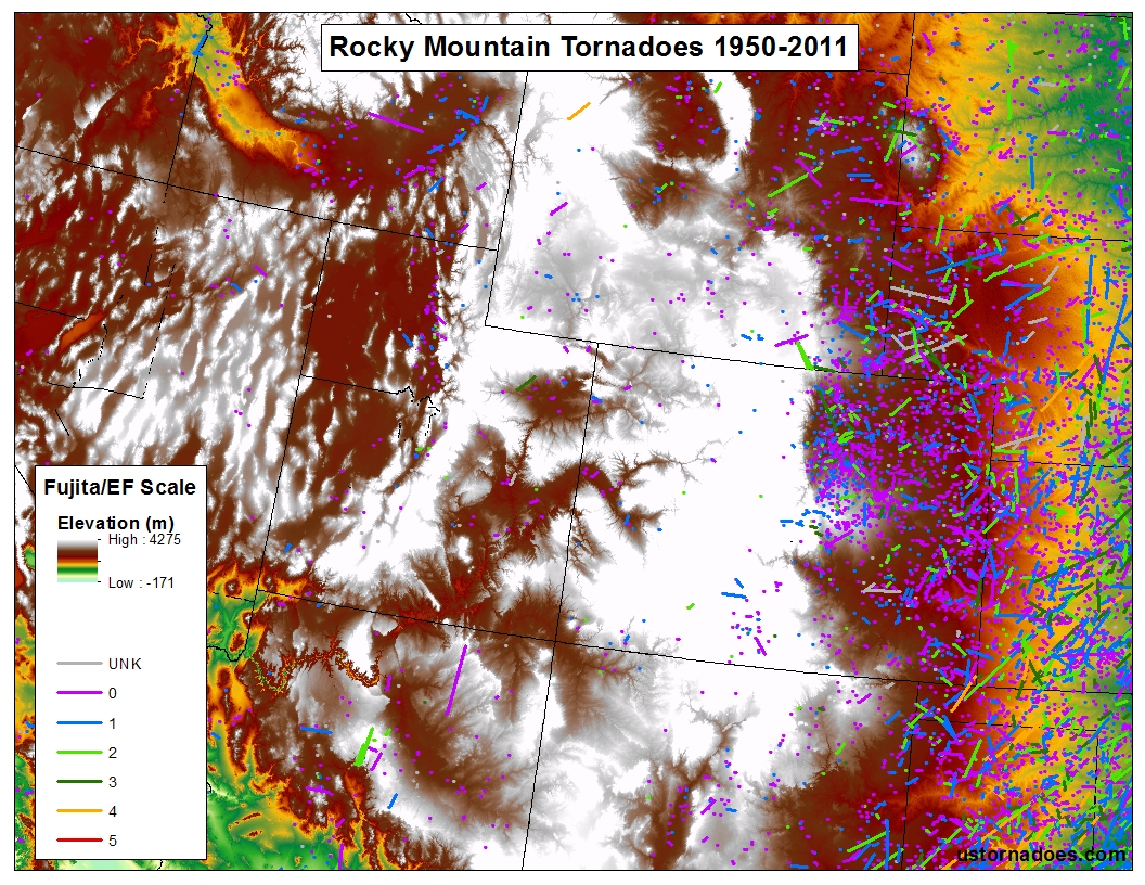
The Rocky Mountains of the United States are likely the most recognized mountains the United States. An impressive range, it stretches more than 2,000 miles from southern Alaska through New Mexico with elevations exceeding 14,000 feet. These mountains are much younger than the Appalachians, at 70 million years old. When comparing the terrain of the Rocky Mountains with spatial tornado coverage some interesting geographical patterns emerge.
Notice the sharp gradient of tornado coverage just to the east of the mountains, quite literally outlining the edge of the terrain. The lee-side of the Rocky Mountains is prime territory for convective development and incipient tornadogenesis during storm season. The terrain effects of the eastern Rocky Mountains can often override less than desirable atmospheric conditions conducive for tornado development.
Despite the impressive elevations, there have been some notable tornadoes within the Rocky Mountains, including a F4 tornado at 10,000 feet over the Teton-Yellowstone landscape of northwest Wyoming (the orange tornado track just below the title-box) and a recent tornado in July 2012 near Mt. Evans, Colorado at nearly 12,000 feet. These two tornado events are discussed in further detail below.
The Cascade Mountains
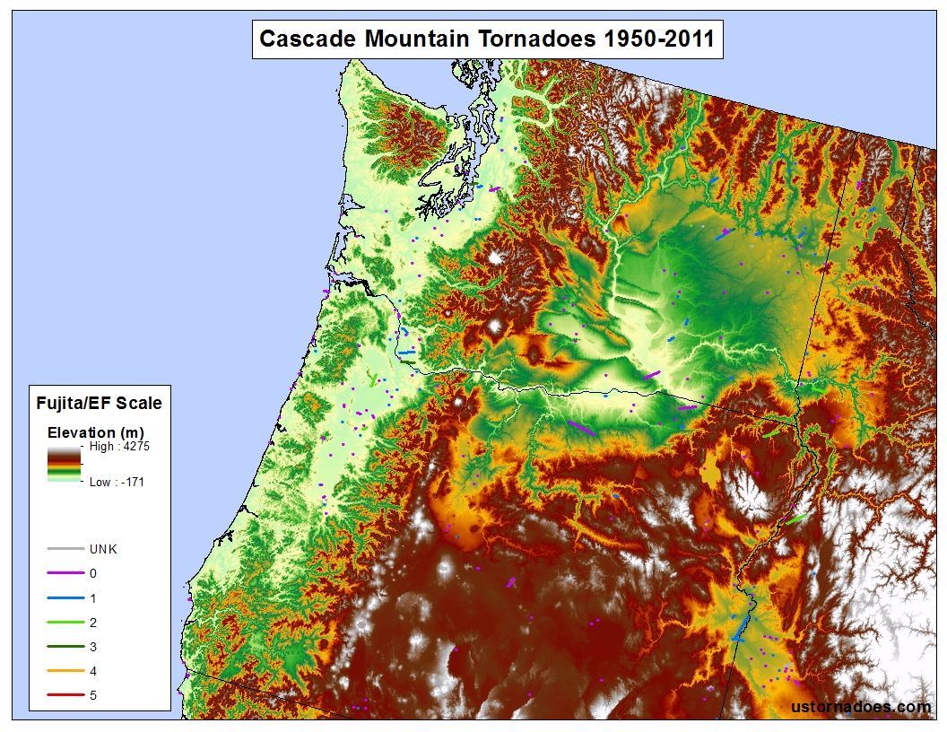
The Cascade Range is an impressive western mountain range that stretches from British Columbia, Canada to northern California and features elevations upwards of 14,000 feet (the popular Mt. Rainier towers at 14,411 feet).
In comparison to the tornado coverage surrounding the other mountain ranges, the Cascade Range features the lowest spatial coverage, with only a handful of F3/EFs during 1950-2011, and no violent F4/EF4s or F5/EF5s.
The relative lack of tornado coverage is most likely due to the regional climate. Situated at the higher latitudes of Oregon and Washington State, this region is characterized by a cool, moist maritime climate. This maritime air from the Pacific Ocean creates an inherently stable environment unfavorable for frequent tornado development.
The Sierra Nevada Mountains
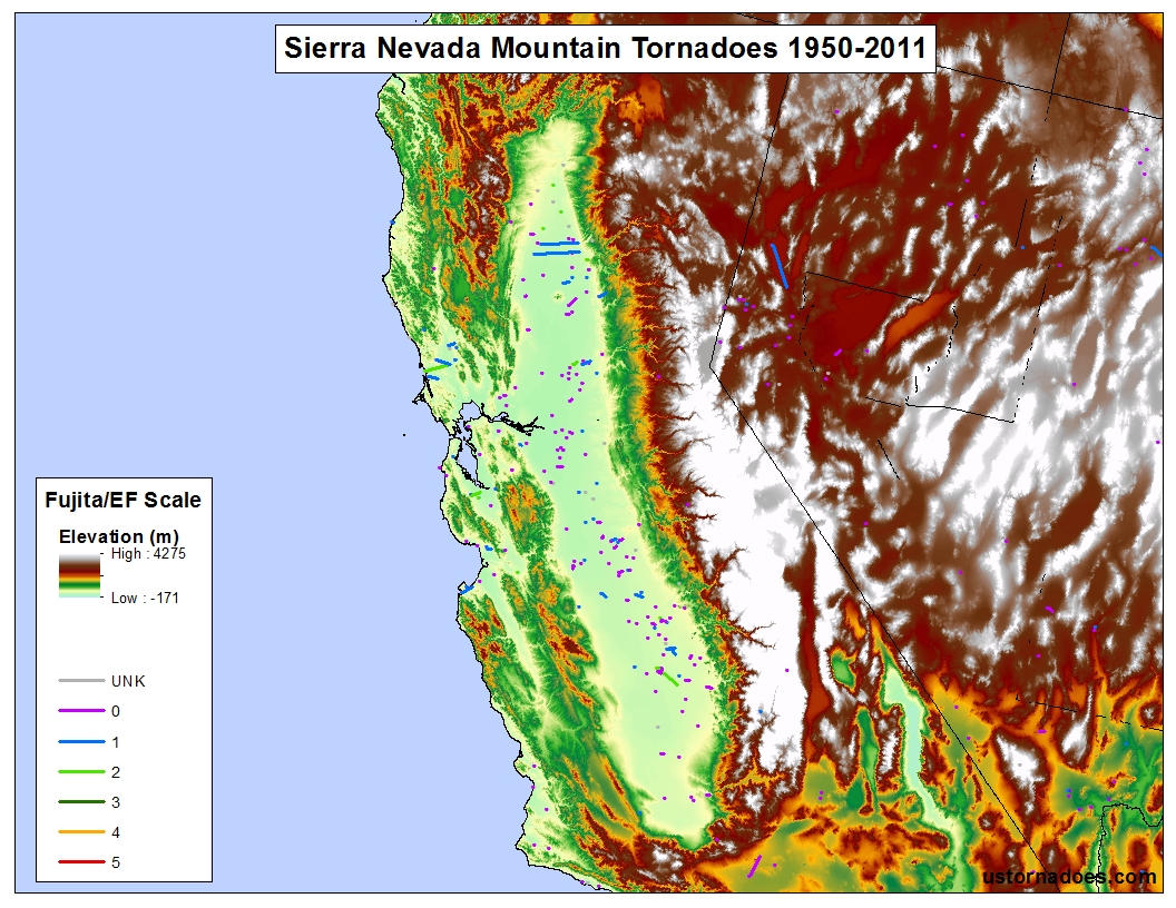
Surprisingly enough, the highest peaks in the contiguous United States can be found in eastern California as part of the Sierra Nevada Mountains. The tallest, Mt. Whitney at 14,495 feet, exceeds the highest peaks of both the Rocky Mountains and Cascade Range.
Like the Cascade Range to the north, the maritime influence of the Pacific Ocean has an influence on environmental stability resulting in less frequent tornado events. Another climatic aspect of this region includes the hot and dry easterly desert winds that blow in from the Mojave Desert. Hot and dry winds are not very conducive for tornado development, though land spouts have been noted nearby at times with robust convection. (Dust devils and firenados in this region, however, are another story!)
One fascinating geographical pattern to point out: can you find the Central Valley? Situated in between the coastal mountains and the Sierra Nevadas, the Central Valley in central California is a large and flat open valley characterized by a warm and moist Mediterranean climate. As you can see on the map, tornadoes occur fairly frequently in this region, most often in winter or spring than at other times of the year.
Case studies
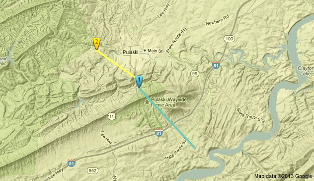
Pulaski, Virginia – April 8, 2011
Two tornadoes from a single supercell thunderstorm occurred at almost 2,000 feet near the town of Pulaski, Virginia on the evening of April 8th, 2011. One tornado was rated an EF1 and a second tornado rated an EF2.
What was interesting about these two tornadoes was that they were separated by a mountain known as Draper Mountain. The potential topographic influence of this ridgeline on those tornadoes was examined in my thesis. In short, the rapid change in elevation due to the storm crossing the ridge may have had a profound effect on the rotational strength of the rotating updraft (mesocyclone).
When the supercell mesocyclone encountered the sudden decrease in elevation on the lee-side of Draper Mountain, that may have caused the updraft to stretch and tighten and thus rotate faster; a phenomenon known as vorticity stretching.
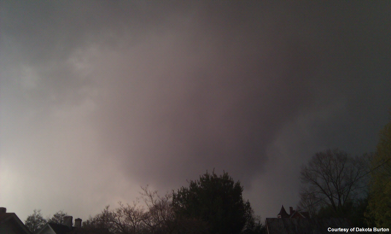
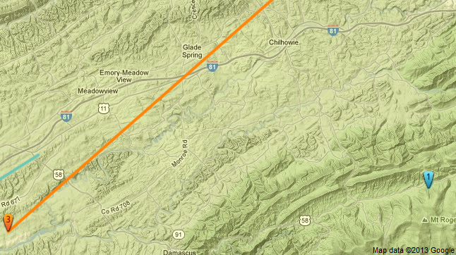
Glade Spring, Virginia and Mt. Rogers — April 27, 2011
Like the Pulaski tornado, these tornadoes occurred deep within the southern Appalachian Mountains. They represented two separate tornadoes that happened on the same night of April 27th-28th, as part of the major southeast outbreak of April 25th-28th.
The Glade Spring tornado (orange track) was an EF3 that occurred around 2,000 feet, and caused devastating damage in the town of Glade Spring. That same night an EF1 tornado (bottom right-hand corner of the map) ripped through a campground near Mt. Rogers at nearly 4,000 feet.
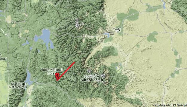
Grand Teton-Yellowstone, Wyoming – July 21, 1987
During a rare and incredible meteorological event, a F4 tornado occurred at 10,000 feet in northwest Wyoming on July 21st, 1987.
The tornado traveled through the Teton-Wilderness, Yellowstone National Park, and crossed the Continental Divide. It is still the strongest tornado ever recorded for the state of Wyoming, a state on the edge of the Plains that sees numerous tornadoes many years.
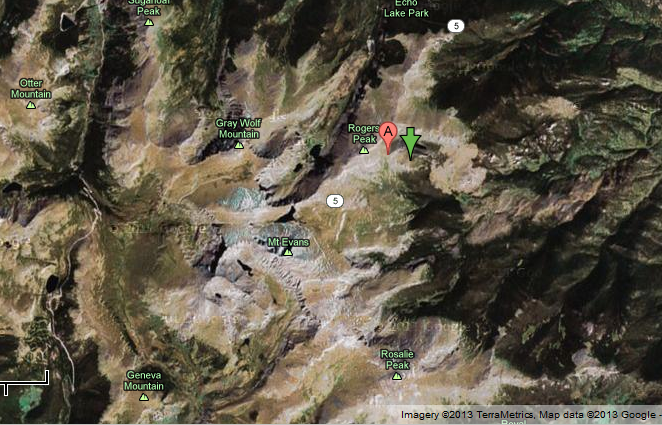
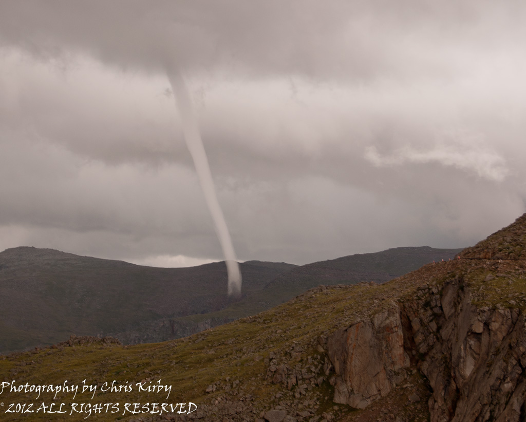
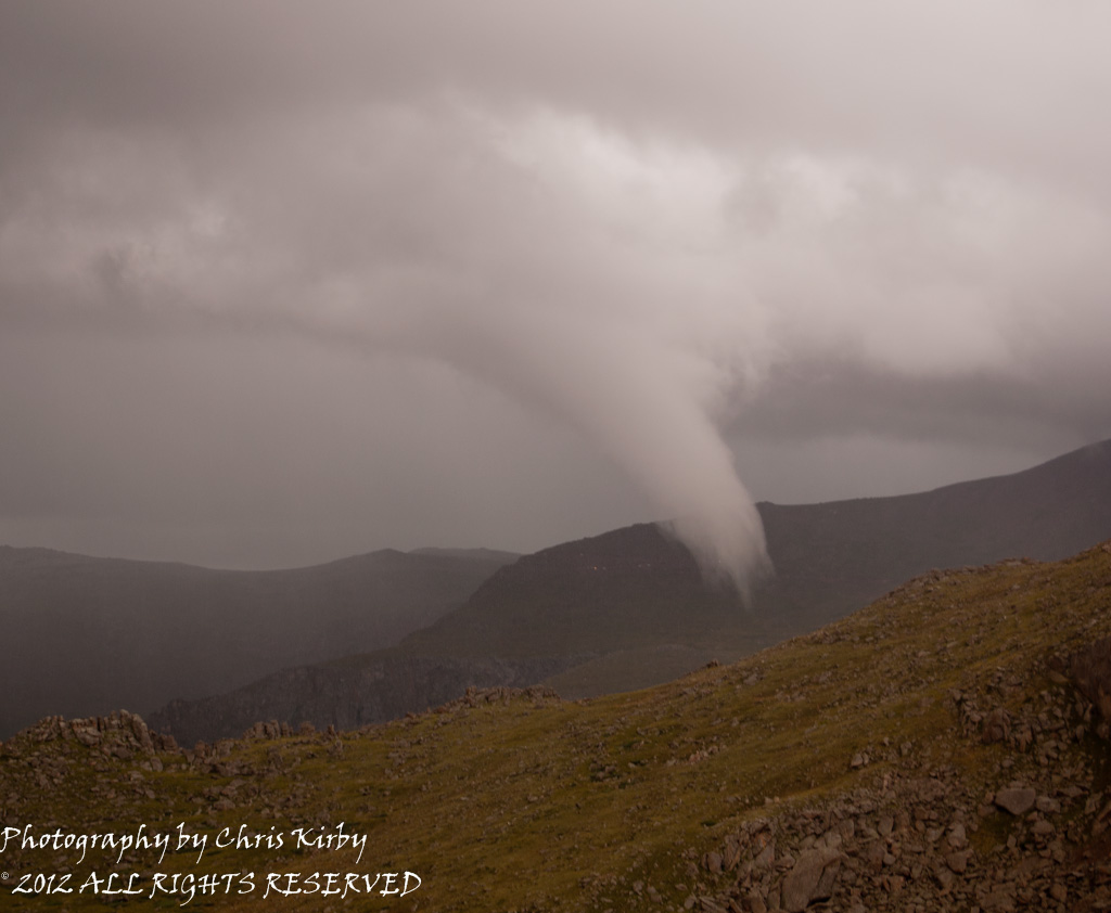
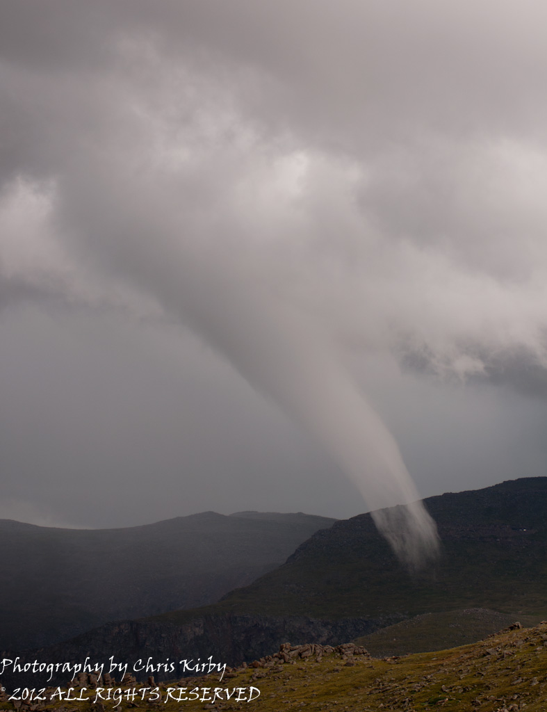
Mt. Evans, Colorado – July 28, 2012
Last summer, when a tornado formed near Mt. Evans and Roger’s Peak within the Rocky Mountains of Colorado, many were surprised. But, as outlined above, mountain tornadoes do happen!
This was one for the books. The National Weather Service in Boulder confirmed the tornado traversed across elevations of 11,800 feet, which is right around the elevation the record holder was observed at in Sequoia National Park, California. Weather photographer Chris Kirby was on scene to capture incredible images of the event. His awesome pictures are below.
Conclusion
This article discussed the relationship between high elevation mountain environments and tornado climatology. The first portion discussed atmospheric stability as the main contributing factor for the relative scarcity of tornado events within mountainous environments.
The next part analyzed the spatial distribution of tornado coverage in respect to the four major mountain ranges in the contiguous U.S. Lastly, case studies of high altitude tornadoes were reviewed.
While this article acknowledges that tornadoes are less common at higher elevations and mountainous terrain, it also debunks the myth that “tornadoes don’t happen in mountains.”
References…
Scott, Doug (Ed). (2006). Guide to Mountains. Buffalo, NY: Firefly Books, Ltd.
Teton-Yellowstone Tornado. In Wikipedia. Retrieved March 11, 2013, from http://en.wikipedia.org/wiki/Teton%E2%80%93Yellowstone_tornado
Tornado History Project. Retrieved March 13, 2013, from http://www.tornadohistoryproject.com/
Latest posts by Kathryn Prociv (see all)
- Halloween tornadoes: The spooky historical facts - October 28, 2013
- From domestic to international: Tornadoes around the world - July 25, 2013
- Cialis und Wetter : Leidenschaft bei jedem Wetter und in jeder Jahreszeit - July 25, 2013
You should look into the EF4 tornado from April 27th, that impacted the Smoky Mountains in Eastern Tennessee.
Great read!
Matt
On April 27,2011 the impossible happened! An EF4 tornado was seen off 6-mile road/HWY 336 crossing over the mountain range just south of Chota rd. into the Happy Valley area and northeast into Sevier county.
for more info: http://www.smokiesinformation.org/blog/tornado-damage-in-the-park/
http://www.srh.noaa.gov/mrx/?n=terraininfluences
http://www.knoxnews.com/news/2011/sep/17/smokies-tornado-damage-nobody-has-ever-seen-like/
Thought about that one too. Included this vid on it in post on the violent tor of the outbreak:
http://www.youtube.com/watch?v=PlnGMxBGk6I&
https://www.ustornadoes.com/2012/04/27/videos-of-the-violent-ef-4-and-ef-5-tornadoes-on-april-27-2011/
Maybe a future post idea for Kathryn!
Thanks for the suggestion Matt! Ian I like the idea of a future post for sure! Have either of you seen this video? It was also from the April 2011 outbreak, but in Alabama.
http://www.youtube.com/watch?v=2yHUHpC1fgo
if you want to see a tornado in a high range mountain, you can see a footage of one of them in the andes range, maybe in the argentinian-bolivian border or the argentinan.chilian border, at 6000 meters above the sea level, in a video posted in youtube, the name of the video is tornado en la cordillera de los andes -catamarca-argentina , it was posted by IntiHuaico La Rioja , the footage was created by a climber in a group of alpinists or climers….
Experienced a tornado in our remote mountain community just this month. It was short lived and very concentrated, hitting our friend’s livery, ripping their horse shed right out with its concrete pilings and throwing it in a disheveled pile 60 feet away. Roofing was ripped form sheds and corrugated metal went flying. I was when it hit the corral that it picked up dust and you could see it’s funnel reaching 300+ feet in the air with tar paper and other debris flying around in it. Corrugated metal was driven 3” into a picnic table and a large utility shed was lifted off its base and moved a couple of feet. Their gas tank (empty thankfully) was torn from its stand and tossed 30 feet away. Thankfully, the horses were still on their lowland pasture.
Definetly interested in the f4 in smokey mtns along with the extremely rare occurrence of f4 in Parker dam state park 69 miles to lock haven pa then beyond.
I think some said it might have been f5 possibly. Out of all the 21 pa tornados May 31 1985 looks like it traveled longest distance also!
We need to stop building mc mansions and build so homes can be more robust so as to survive. The damage we are getting is due to cheap building and greed. There are new technologies and with high lumber prices we have a chance to make a change.
a home made of paper, stone, wood, aluminum soda cans, caramelized sugar? the sky is the limit as to what you use to build a home if it is built to standard building code meant to resist a certain speed of wind. the only real difference would be the size of the projectiles that are ripped from the home. Wood doesn’t tend to stay in 2/4 form, and tends to splinter. Brick homes tend to make cannonballs from the bricks, they don’t disintegrate very much.
Wood homes tend to cost on average 2% less than it costs to build standard masonry, or poured concrete home of equal size. They also go up a lot faster.
The belief that tornadoes can’t traverse hills infuriates me like you wouldn’t believe. Whenever and wherever the conditions are right, they’ll drop.
Here’s two instances that happened in Pennsylvania.
~Moshannon State Forest EF4 that went through a mountainous forest.
https://m.youtube.com/watch?v=Qk0r1jHEYIQ&pp=ygUebW9zaGFubm9uIHN0YXRlIGZvcmVzdCB0b3JuYWRv
~On 6-2-1998, the Pittsburgh suburb of Mount Washington got hit with a tornado. Mt. Washington is on top of a hill that overlooks Downtown Pittsburgh.
Here’s the photo the local news station captured.
https://assets3.cbsnewsstatic.com/hub/i/r/2023/06/02/7c2cda60-b7c5-4b7b-968d-a6c9d68ff5e9/thumbnail/1200×630/7335bd6729fee53f99934167d046ac7b/kdka-pittsburgh-mt-washington-tornado-1998.png?v=2a3c5d91939c9bf28fa0bc6fdfacfdd4
https://www.cbsnews.com/pittsburgh/news/mt-washington-tornado-25th-anniversary/