By Ian Livingston and Andrew Berrington
As dusk turned to dark on the evening of May 4, 2007, what started as a beautiful striated supercell turned into a tornado machine.
At first, the tornadoes were quick, relatively small, and short lived. Around 9 p.m. — right at the end of civil twilight — the first “big one” of the night touched down. It started off somewhat slender as it danced along the fields of southern Kansas. But it morphed with each passing minute. It gained strength and it stealthily churned in the direction of Greensburg.
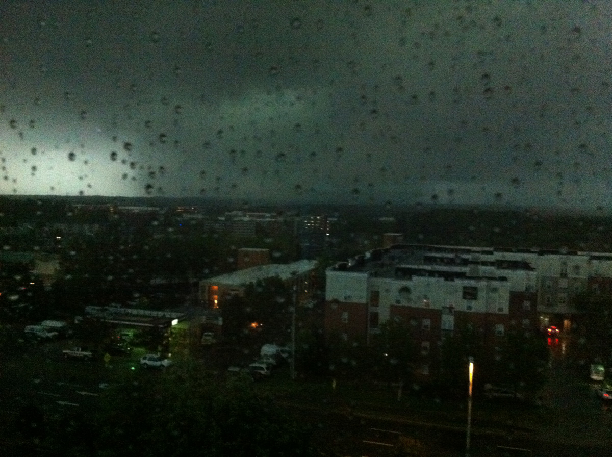
As the tornado neared the town, it took on the much-feared “wedge” shape, visibly crowding the horizon in the lightning flashes. These are tornadoes that appear wider than they are tall. They’re usually bad news, primarily because they are so huge. Amidst a slew of increasingly urgent warnings, the town of Greensburg prepared as best it could. Life-saving equipment was moved out to wait. The 1,500+ inhabitants of the town were as ready as they could be.
Around 9:50 p.m., the tornado that would almost fully destroyed Greensburg began shredding it to bits. The tornado had already been on the ground for almost an hour, and was entering the final part of its 26 mile track. At 1.7 miles in width, the hit would prove unnecessarily excessive. Terrible and miraculous all at once, “only” 11 residents lost their lives. Nearly 70 others were injured.
The first EF5 on the launched-in-2007 Enhanced Fujita Scale, Greensburg was also the first F/EF5 in the state of Kansas since the Andover tornado of April 26, 1991. It’s the most recent to happen in the state as well.
While the Greensburg monster is what the day is known for, the supercell responsible was an incredibly prolific tornado producer. As if the hit already taken wasn’t enough, the indescribable destruction also came the day prior to a major tornado outbreak impacting the same region.
‘Textbook’
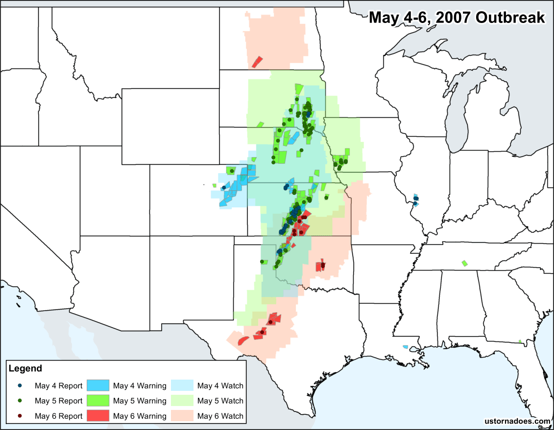
Born of a classic setup for a Plains tornado outbreak series, from May 3 through May 6 (the duration is open to interpretation, for this we are talking the main trough before it began to degrade) there were 139 tornadoes, mostly in the Plains from South Dakota to Texas. While the biggest day of the bunch was May 5 — the 4th is when the most disastrous portion of the several-day period occurred.
It all began with a powerful and slow-moving low pressure trough dipping through the northwestern U.S. through May 3. A front-end vorticity maximum and attendant jet streak helped spark off some storms and tornadoes across northern Colorado. The preview to a multi-day volley.

As the first wave in the series rotated through the trough, the next one helped carve the buckling jet-stream deep into the southwest U.S. In the meantime, low pressure developed in the lee of the Rockies, as they tend to do in big Plains tornado events.
When May 4 dawned, the citizens of western Kansas stared down a “moderate risk” of severe weather and tornadoes. In less-scientific parlance, this is the second highest threat category from the Storm Prediction Center (SPC). SPC is the national office in charge of forecasting storms, and issuing severe weather watches.
Even for a storm-hardened population, moderate risks are the days that get attention when they are issued.
The day of Greensburg was one where there was some question if it might “bust.” A late show, it ended up that a capping inversion further south kept storms limited through the day across Oklahoma. The exception to that rule was a lone supercell, which produced a narrow, but strong tornado in Ellis County. This storm was documented by Reed Timmer and Joel Taylor, as seen in the video below.
Towards dusk, another supercell formed to the north of the storm which produced the tornado in the video.
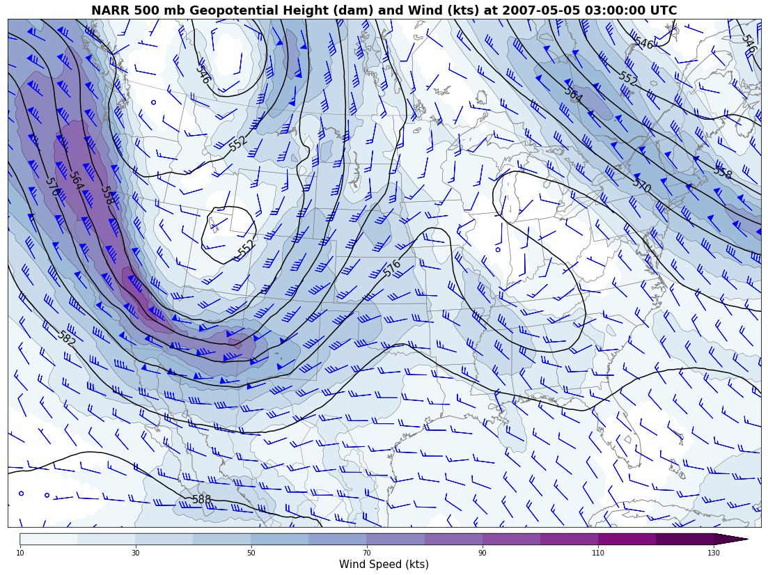
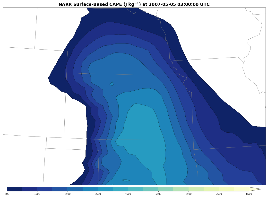
This storm, which would ultimately become the “Greensburg supercell,” intensified as it shifted towards the Kansas border. Concurrent with this development was a strengthening in the wind fields at all levels as the low pressure trough approached from the west. Very high levels of instability were present — CAPE in excess of 3500 J kg¯¹ provided ample opportunity for explosive updraft development.
While most thunderstorms tend to weaken or transition into complexes in the Plains after dark, the Greensburg case was an exception. Thanks to continued moistening, due in part to a strong low-level jet stream a few thousand feet above the ground, conditions remained favorable well into the overnight.
By 10 p.m. CDT, or roughly when the Greensburg tornado moved through the town, it was abundantly clear that a high-end environment was in place.
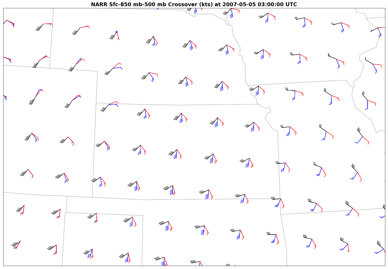
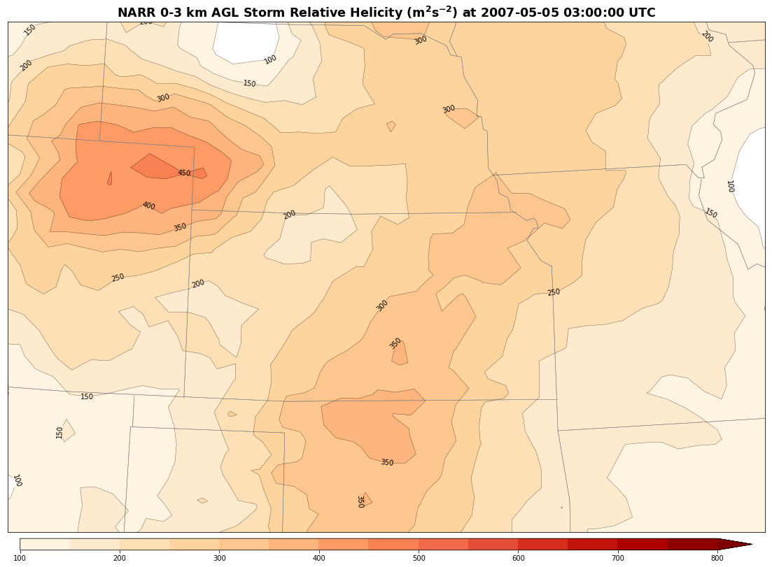
An examination of the crossovers (winds at different heights) at this time reveals highly favorable veering with height over Kansas. Nearly southeasterly flow at the surface, shifting to nearly west-southwesterly at 500 mb. All with strong southerly flow at 850 mb.
Large, clockwise-curved hodographs in the low levels result from these types of wind fields and ambient storm relative helicity values in the lowest 3 km were in the 250-350 m² s¯² range. As a result, a coupling of high instability and plentiful low level shear characterized the environment. Therefore, conditions were quite ripe for strong and long-lived tornadoes in west-central Kansas, since the supercell had already overcome the capping inversion.
The thunderstorm was of a truly historic magnitude, one that has scarcely been seen even in the most tornado-ravaged portions of the United States. While the parameter space was indeed high end, the amount of energy that this supercell expended during its exceptionally long lifespan dwarfs most comparative events that can be thrown at it.
Documenting the path of destruction
For those following the storm and relaying critical information, figuring out where one end of the Greensburg tornado started and the other ended was tricky, even in frequent lightning flashes illuminating the beast. For those watching the storm unfold on radar, it was truly jaw dropping.
While chatting with Mike Smith, author of Warnings: The True Story of How Science Tamed the Weather, the radar signature of this storm came up. He pointed out that, “the tornado was at nearly perfect range from the radar to demonstrate this was no ordinary tornado. The velocities showed this was a violent, violent tornado.”
The radar loop below covers the tornadic life of the Greensburg cell. The very strong and long-lived rotation is clearly evident, as are some other things. Note the repeated “hand-offs” in the velocity couplets between Greensburg and Great Bend. One circulation weakens as another takes over to the east. This is classic “cycling” of an intense supercell and in this case, was responsible for the birth of multiple large tornadoes.

Radar closeups: 4-panel over Greensburg | Zoom reflectivity (smoothed) | Velocity
As the monstrous tornado cut a path towards Greensburg, warnings from the NWS office in Dodge City became increasingly dire.
The strength of the velocity couplet on the KDDC NEXRAD reached a level that has only been seen a few times on a WSR-88D. At 9:41 p.m. CDT, a tornado emergency was issued by Mike Umscheid, strongly hinting of the impending destruction.
It was one of the only uses of a tornado emergency (born during the May 3, 1999 outbreak) at the time, and the warnings are heavily credited with keeping the disaster as minimal in the death toll category as possible.
Smith, also a Kansas resident in addition to meteorologist and author, gave high praise to all involved that night. “The NWS team at [Dodge City] was highly experienced in handling these types of storms. The Wichita TV market had terrific meteorologists who were able to convey the critical nature of the situation,” he said.

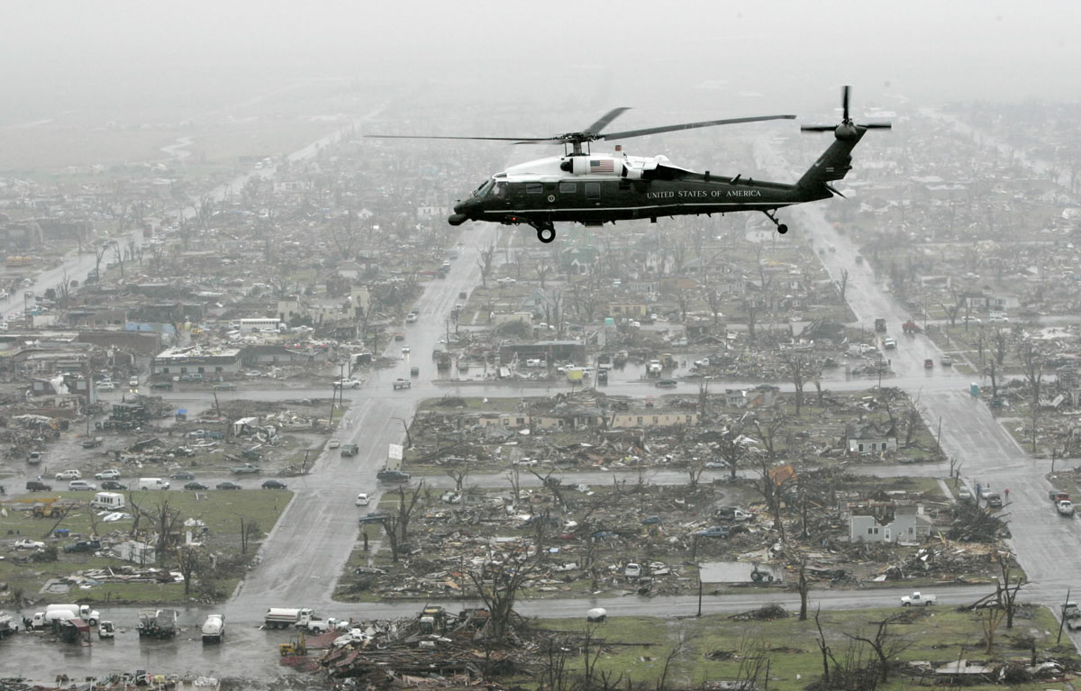
Despite great warning, Greensburg is only about 1.5 miles wide at its widest. So the tornado impacted the whole town in some way. The scene was perhaps better described as post-apocalyptic than post-tornado.
Violent tornadoes — those rated F/EF4 or F/EF5 — cause near total destruction in the area of their worst wind. When it comes to houses, the difference between a 4 and a 5 is often whether the house is rubble still in place or if the house is blown away entirely.
Trees are debarked in the strongest tornadoes like Greensburg, leaving them standing as disfigured sentinels amidst piles of rubble, or snapped and sent to far-off places. Those standing might also feature puncture wounds from things like a flying sipping straw, or other weird objects. Vehicles are tossed as far as a mile or more in some cases. Even basements are not a guarantee of survival in the worst events, as projectiles may be launched only to later fall into them.
That was the state of Greensburg after the tornado passed. In a brief discussion about his experiences chasing the tornado, long-time storm chaser and tornado expert Dick McGowan told us, “I’ve seen destruction from violent tornadoes, but not an entire town wiped off the map. Worse yet, it was “in complete darkness, with only lightning from the passing supercell briefly illuminating it.”
The Greensburg supercell was extraordinarily prolific
The persistence of this storm and its repeated cyclical tornado barrages was staggering.
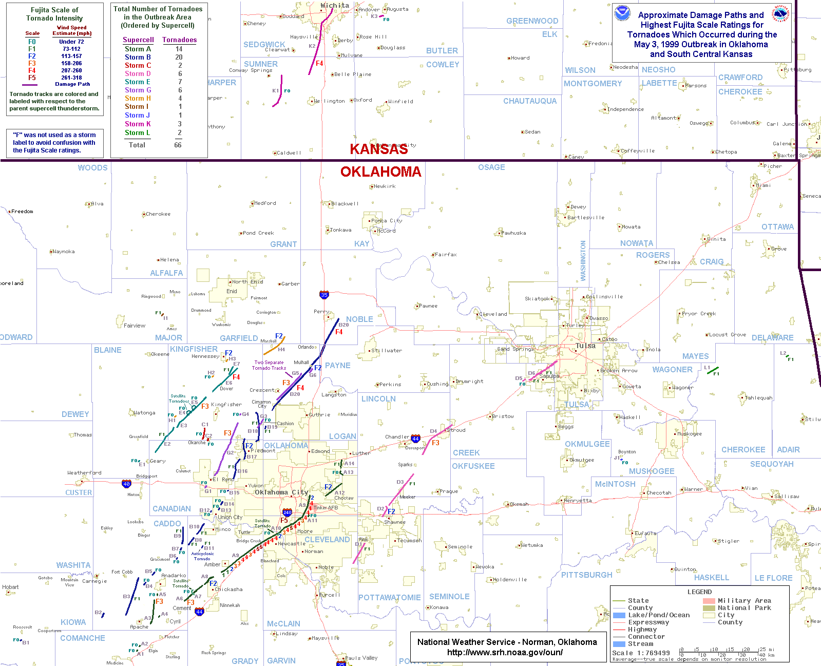
Even some entire outbreaks (and notable ones at that) do not give rise to so many tornadoes. A couple of comparative storms developed during the May 3, 1999 tornado outbreak in the Plains. Cell B from this event produced 20 tornadoes and is perhaps the closest in nature to the Greensburg storm that has been seen in the Plains in the modern era. It also unleashed its worst, a long tracked F4 through Mulhall, Oklahoma, after dark.
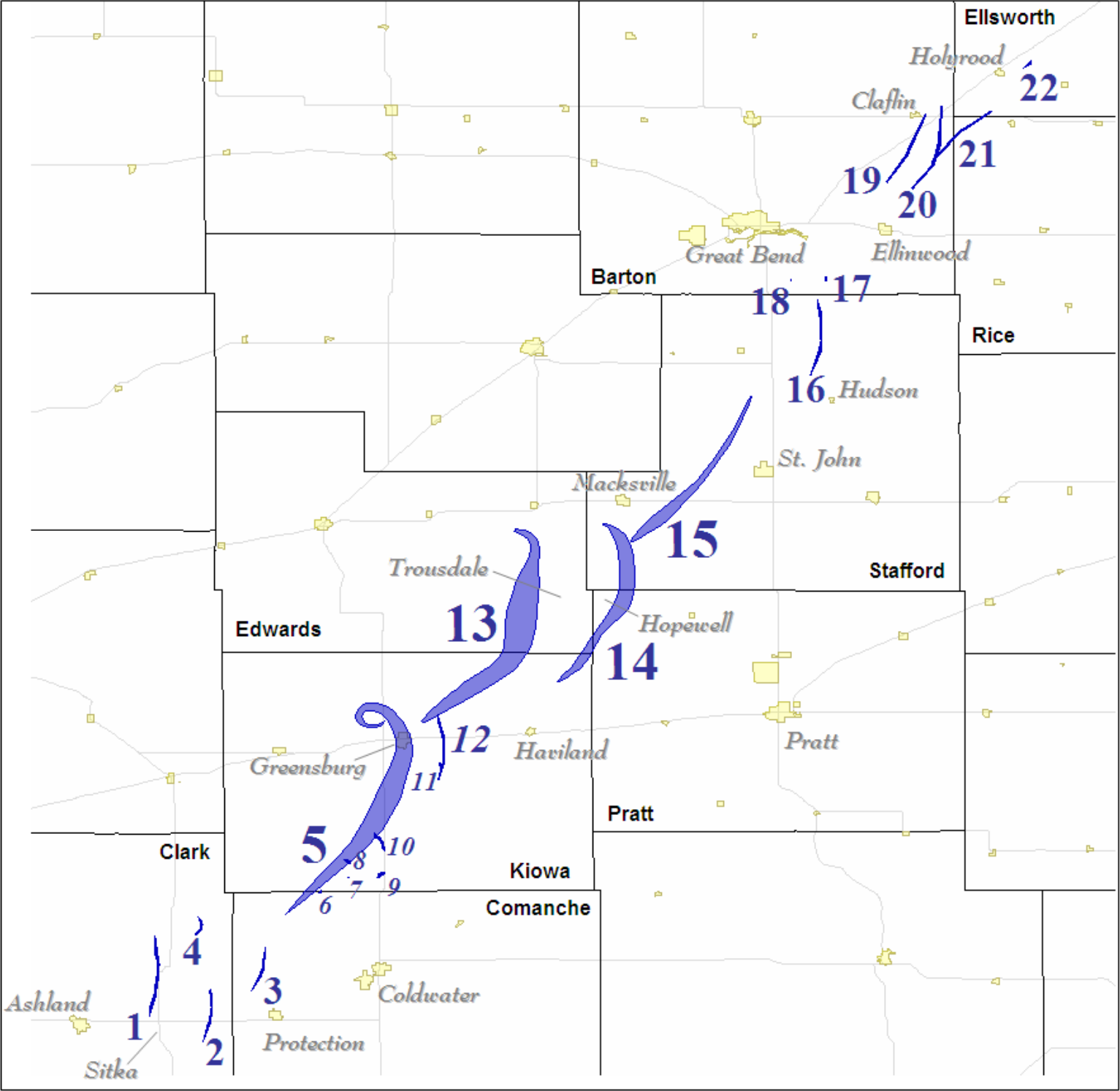
It’s worth noting that an even larger tornado (#13 on the map above) developed immediately following the Greensburg tornado’s demise. At times close to 2 miles in diameter, this immense vortex caused significant damage near Trousdale, where a combine was thrown 1/4 of a mile and dismantled.
https://twitter.com/stormpics/status/852314723534221313
Given the intensity of the radar signatures documented in Leslie Lemon and Mike Umscheid’s paper, it’s possible this tornado was even more potentially destructive than the Greensburg tempest. Two additional and very large/strong tornadoes (#14 and #15 above) followed that one as well. It is very fortunate that this area of Kansas features considerable spacing in between establishments, or the same fate that befell Greensburg may have happened elsewhere.
History tried to repeat, but warnings keep getting better
The event was eerily similar to another tragic night 52 years earlier in Kansas. On May 25 in 1955, in the midst of a tornado outbreak across the southern Plains, an evening supercell formed in northern Oklahoma and produced an F5 in Blackwell, killing 20.
The same storm then crossed north-northeastward into Kansas and unleashed another exceedingly violent tornado. 80 people were killed as most of the sleeping town of Udall and surrounding vicinity was eviscerated around 11 p.m.
Numerous homes in Udall literally vanished from their foundations, and even large buildings such as the local high school suffered near-total ruin. Vehicles were also thrown exceptional distances and warped into forms more befitting of a crooked house. This catastrophic F5 remains the deadliest in Kansas’ tornado-heavy history.
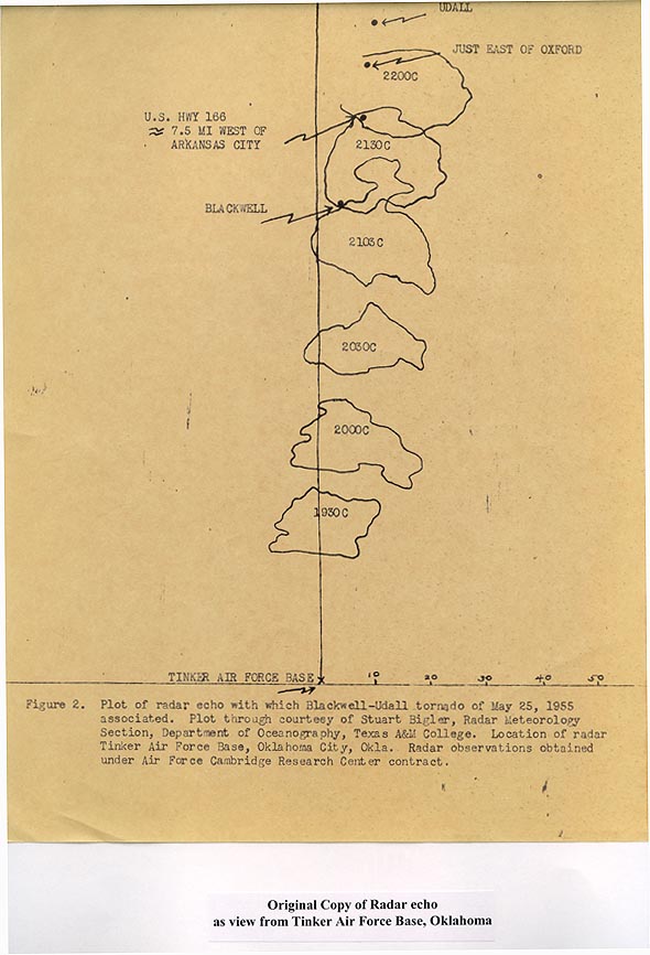
A comparison of the overlay from the primitive Tinker Air Force Base radar and the Greensburg radar loop above shows some stark similarities between the two supercells. This is especially apparent with the 2130C overlay (near Blackwell) and when the 2007 supercell is near/over Greensburg.
The differences in the death tolls highlights the progress that has been achieved in severe weather warning and awareness since that time. The Udall tornado was the catalyst of the storm spotter network that is now in place today and was used to substantial effect around Greensburg.
‘The day before the day’
Chasers have a term for big chases that come the day prior to a major tornado outbreak. The reasons for it are several fold. Chiefly, big outbreaks often come from large low-pressure trough ejections out of the mountains and into the Plains. These troughs can take up the pattern of half the country, or so.
Day before the day type days are often small on the forcing for storms but can be big on the results. The small on forcing part tends to favor isolated storms, or blue sky busts. The more isolated the storm, the more likely it can use the environment to its full potential. And of course, it only takes one.
Greensburg was textbook day before the day. Still, it was just a preview of what was to come.
On May 5 and into May 6, a major tornado outbreak (or a continuation of a multi-day outbreak, depending on how you define it) dropped about 100 more tornadoes during the remainder of the main event. To put May 5 tornadoes in perspective: it is among the most tornadoes on record on any one day. It is generally a footnote in history, thanks to what happened the day prior.
Much of the same region ended up under risk for tornadoes on May 5. A “high risk” was issued. This is the most dangerous of all outlooks from the SPC. It included the Greensburg region, no doubt causing fear among the populace given what had just happened.
On May 5, tornadoes struck from Texas to South Dakota. A slew of touchdowns occurred near Greensburg. One west, and many to the east and northeast, including a long-track strong tornado (video above) that started just a few miles northeast of the freshly-reeling town.
Despite the fact that there were so many additional tornadoes — 16 of which were strong — only one person was killed in this round.
The Greensburg disaster was as much bad luck as anything. Hitting a target like that isn’t easy. It will happen over time, especially as town footprints grow, but even in tornado country the odds of taking a hit like that are low. It wouldn’t be the first set of odds the town would defy.
Greensburg is still kicking, 10 years later
The mere act of surviving a tornado like the one that hit Greensburg is remarkable. Weird things happen in winds near and past 200 mph. Greensburg was a hefty EF5, with estimated winds of 205 mph. It also impacted most of the people who resided there when it hit. Everyone who went through that night in the town is a hero in their own way.
The town has been rightfully lauded for returning in the first place. Quitting would have been easier. In its rebirth, Greensburg also became known as a model of green development, ranking among the top towns in the country when it comes to efficiency, renewables, and clean energy standards.
All this said, the population of the town at the 2010 census was about half of what it was in the 2000 census. The numbers loss to the town began in earnest before the tornado, and the tornado occurred just before the “Great Recession,” so not all ills can be blamed on the tornado. Despite its immense beauty, the High Plains is a tough place to live — it always has been.
The truth is, many towns such as this end up ghost towns. And while that is still not entirely out the question for Greensburg, signs that it will continue to pull through the aftermath continue to outweigh any negative ones.
A new airport is set to serve the broader region. Arguably the most important thing in rural life, a vibrant school, is a Greensburg reality. Before the tornado it served just the small town. Now it fully serves a broader community, one which came to Greensburg’s aid that fateful night. The Big Well is also still there, and arguably looking better than ever.
We’ve been through Greensburg at a few times. It will forever live in the hearts of those who are interested in severe weather. It’s always good to stop in town when passing through. Our chase crew spent the afternoon of an amazing intercept in Rozel, Kansas at an impromptu chaser convention at a gas station parking lot there. We can certainly say we look forward to seeing a prosperous Greensburg on chases in the future.
Links…
The Greensburg, Kansas Tornadic Storm: A Storm of Extremes (PDF)
Facts about the Greensburg Tornado (PDF)
Remembering those who died in the Greensburg tornado
Learning from Greensburg: National Weather Service’s storm warning system saved lives 10 years ago
Aerials of Greensburg Tornado Damage
Ian Livingston, co-founder of ustornadoes.com, is a weather journalist, policy wonk, and storm chaser. Andrew Berrington is an undergraduate student in Atmospheric Sciences at the University of British Columbia, storm chaser, and writer for ustornadoes.com.
U.S. Tornadoes
Latest posts by U.S. Tornadoes (see all)
- March 21-23, 2022 tornado outbreak - March 21, 2022
- Tornado events of 2020 - February 17, 2020
- The tornado outbreak sequence of May 2019 - May 30, 2019