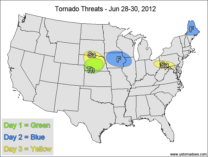
1-3 DAY
Nebraska, northern Kansas — POTENTIAL: Low — CONFIDENCE: High
Storms will be forming in a fairly dry low-level environment with weak mid-level shear, but there with moderate to high CAPE and good directional shear storms that form could potentially become tornadic.
Friday
West-central Midwest — POTENTIAL: Low — CONFIDENCE: Normal
Storms forming along a stalled frontal boundary will be in a similar environment as Thursday, with moderate to high CAPE, low to moderate shear and low-level moisture issues. The overall shear looks marginally better compared to Thursday.
Maine — POTENTIAL: Very Low — CONFIDENCE: Normal
Storms forming near the triple-point of a disturbance will be in a moderate CAPE and moderate to high shear environment, but directional shear will be fairly weak overall, limiting the tornado potential.
Saturday
Central Mid-Atlantic — POTENTIAL: Very Low — CONFIDENCE: Normal
Storms that form within the risk area may have enough low-level rotation to become tornadic within a moderate CAPE and moderate shear environment.
Nebraska, southern South Dakota — POTENTIAL: Very Low — CONFIDENCE: Normal
A cluster of storms forming in a moderate CAPE and low shear environment will have enough rotation to potentially come tornadic, but a lack of upper-level support and fairly dry low-levels will keep the potential very limited.
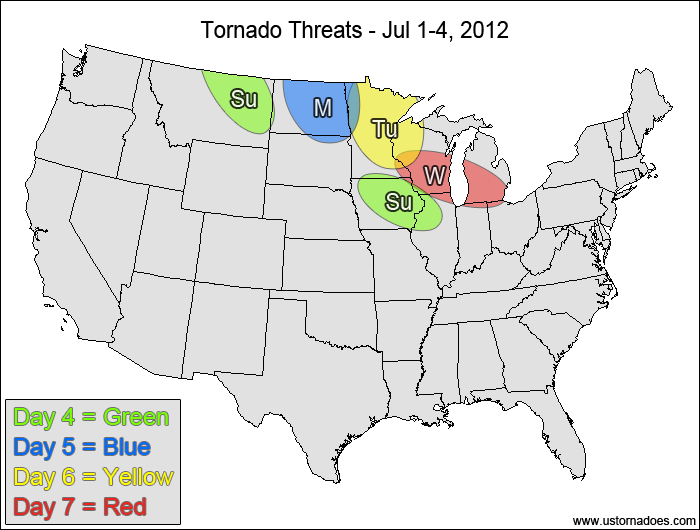
4-7 DAY
Eastern Montana — POTENTIAL: Low — CONFIDENCE: Normal
Storms forming in a low to moderate CAPE and moderate to high shear environment could become tornadic. However, a lack of low-level moisture will inhibit tornado formation.
West-central Midwest — POTENTIAL: Very Low — CONFIDENCE: Normal
A moderate to high CAPE and low shear environment will be in place over the risk area, with sufficient directional shear for possible tornadic activity.
Monday
Northern Plains— POTENTIAL: Low — CONFIDENCE: Low
A short-wave trough moving across southern Canada and the northern Plains could trigger storms with tornadic potential in a low to moderate shear and moderate CAPE environment. Model spread has become significant enough at this point to keep confidence lower than normal.
Tuesday
Northwestern Midwest — POTENTIAL: Low — CONFIDENCE: Low
As the short-wave trough pushes eastward, it will have a similar environment as Monday in which a tornado or two is possible.
Wednesday
Western Great Lakes — POTENTIAL: Very Low — CONFIDENCE: Low
Moderate CAPE will still be present near an advancing short-wave trough, however weaker mid-level winds and weaker directional shear will keep the tornado potential to a minimum.
{ "@context": "https://schema.org", "@type": "Article", "mainEntityOfPage": { "@type": "WebPage", "@id": "https://ustornadoes.com/2026/07/30/claiming-mega-wins-free-spins-deals-for-uk-players/" }, "headline": "Claiming Mega…
Getting Started with Daytonaspin: A Guide for UK Players For players in the United Kingdom…
{ "@context": "https://schema.org", "@type": "Article", "mainEntityOfPage": { "@type": "WebPage", "@id": "https://ustornadoes.com/2026/07/30/pink-lady-casino-registration-in-the-united-kingdom-guide/" }, "headline": "Pink Lady…
Understanding Your Payment Options at Extreme Spins Navigating the financial landscape of an online casino…
Understanding the MySpins Welcome Bonus in the United Kingdom For players in the United Kingdom,…
It's peak tornado season. We briefly examine the top outbreaks from April-June.