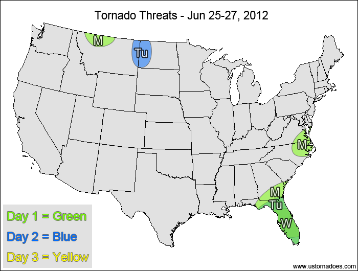
1-3 DAY
Southern Southeast — POTENTIAL: High — CONFIDENCE: Normal
Storms initiated by Tropical Storm Debby will be in a high shear/low CAPE environment capable of producing mostly brief tornadoes.
Southern Mid-Atlantic, North Carolina — POTENTIAL: Very Low — CONFIDENCE: Normal
Storms forming along and ahead of a cold front will have moderate CAPE and moderate shear to organize storms, but mostly unidirectional wind flow and downsloping winds will hinder tornadic development.
Montana — POTENTIAL: Very Low — CONFIDENCE: High
Storms forming in the vicinity of an upper-level low may gain enough rotation to become tornadic within a low to moderate CAPE and moderate to high shear environment.
Tuesday
Florida — POTENTIAL: Medium — CONFIDENCE: Normal
Tropical Storm Debby is forecast to remain just offshore, allowing for tornadic activity to continue in Florida.
Northern High Plains — POTENTIAL: Low — CONFIDENCE: Normal
A strong pocket of upper-level energy will eject out of the main trough, allowing for tornadic development. However, most of the activity is expected to stay north of the border, with a more limited threat to the U.S.
Wednesday
Florida — POTENTIAL: Medium — CONFIDENCE: Normal
Tropical Storm Debby remains a threat for potential tornadoes.
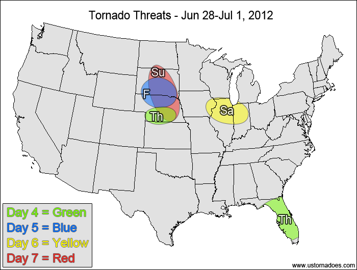
4-7 DAY
Nebraska — POTENTIAL: Low — CONFIDENCE: Normal
Storms forming south of a frontal boundary will be in a moderate/high CAPE and generally low shear environment, with enough low-level directional shear for storms to potentially become tornadic.
Florida — POTENTIAL: Medium — CONFIDENCE: Normal
Tropical Storm Debby remains a threat for potential tornadoes if it stays west or just over Florida.
Friday
South Dakota, Nebraska — POTENTIAL: Low — CONFIDENCE: Normal
Another round of storms is expected in a similar setup to Thursday, though the overall shear profile seems slightly more favorable on Friday.
Saturday
Western Midwest — POTENTIAL: Low — CONFIDENCE: Normal
The same environment that is forecast over Nebraska and South Dakota on Friday will translate eastward into the western Midwest on Saturday.
Sunday
Northern Plains — POTENTIAL: Medium — CONFIDENCE: Low
A short-wave trough is forecast to move into the northern Plains, which could trigger tornadic storms in a high CAPE and low to moderately-sheared environment.
{ "@context": "https://schema.org", "@type": "Article", "mainEntityOfPage": { "@type": "WebPage", "@id": "https://ustornadoes.com/2026/07/30/claiming-mega-wins-free-spins-deals-for-uk-players/" }, "headline": "Claiming Mega…
Getting Started with Daytonaspin: A Guide for UK Players For players in the United Kingdom…
{ "@context": "https://schema.org", "@type": "Article", "mainEntityOfPage": { "@type": "WebPage", "@id": "https://ustornadoes.com/2026/07/30/pink-lady-casino-registration-in-the-united-kingdom-guide/" }, "headline": "Pink Lady…
Understanding Your Payment Options at Extreme Spins Navigating the financial landscape of an online casino…
Understanding the MySpins Welcome Bonus in the United Kingdom For players in the United Kingdom,…
It's peak tornado season. We briefly examine the top outbreaks from April-June.