The week will start on the quiet side until a disturbance starts to kick off storms on Wednesday. Forecast confidence is lower than normal from Friday onward, so keep that in mind when looking at the forecast. By Sunday it’s almost a shot in the dark regarding tornado chances.
No tornadoes expected.
Tuesday
No tornadoes expected.
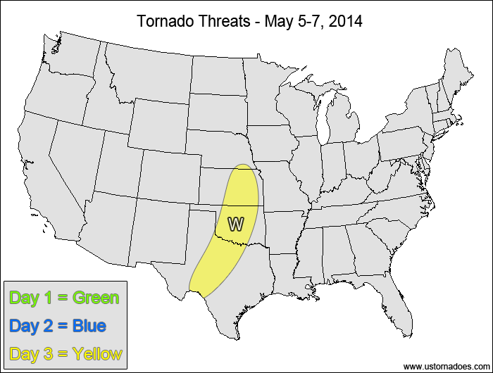
Wednesday
Central and southern Plains — TORNADO RANGE: 0-3 — CONFIDENCE: Normal
Expected Tornado Hotspot: None
Pros: Good speed shear, decent/good directional shear, low to moderate instability
Cons: Late storm initiation that could allow storms to go elevated before becoming tornadic, late arrival of upper-level energy, questionable storm intensity
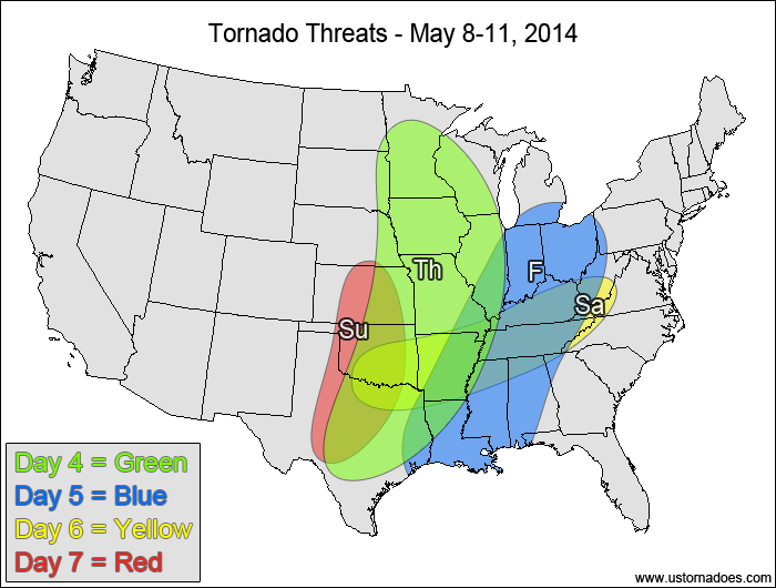
Mississippi Valley, eastern Plains — TORNADO RANGE: 4-12 — CONFIDENCE: Normal
Expected Tornado Hotspot: None
Pros: Good speed shear, decent/good directional shear, low to moderate instability, good upper-level forcing
Cons: Questionable mid-level lapse rates, early convection/clouds contaminating the warm sector, some areas could have backed mid-level winds
Friday
Midwest, ArkLaTex, western Southeast — TORNADO RANGE: 3-8 — CONFIDENCE: Low
Expected Tornado Hotspot: None
Pros: Decent speed and directional shear, low to moderate instability
Cons: Weakening lapse rates, weakening upper-level forcing, widespread clouds/rain over the warm sector, less directional shear
Saturday
Eastern Oklahoma and northeastern Texas to Tennessee Valley — TORNADO RANGE: 0-3 — CONFIDENCE: Low
Expected Tornado Hotspot: None
Pros: Decent/good directional shear, okay/decent speed shear, low to moderate instability
Cons: Weak low-level speed shear, weak upper-level forcing, rising heights in the western areas
Sunday
Central and southern Plains — TORNADO RANGE: 0-5 — CONFIDENCE: Low
Expected Tornado Hotspot: None
Pros: Some hints at moderate/high instability, good wind shear and an incoming shortwave disturbance
Cons: Poor model agreement regarding timing and position of synoptic and mesoscale features
{ "@context": "https://schema.org", "@type": "Article", "mainEntityOfPage": { "@type": "WebPage", "@id": "https://ustornadoes.com/2026/07/30/claiming-mega-wins-free-spins-deals-for-uk-players/" }, "headline": "Claiming Mega…
Getting Started with Daytonaspin: A Guide for UK Players For players in the United Kingdom…
{ "@context": "https://schema.org", "@type": "Article", "mainEntityOfPage": { "@type": "WebPage", "@id": "https://ustornadoes.com/2026/07/30/pink-lady-casino-registration-in-the-united-kingdom-guide/" }, "headline": "Pink Lady…
Understanding Your Payment Options at Extreme Spins Navigating the financial landscape of an online casino…
Understanding the MySpins Welcome Bonus in the United Kingdom For players in the United Kingdom,…
It's peak tornado season. We briefly examine the top outbreaks from April-June.