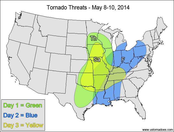
The tornado threat in the U.S. peaks today as a disturbance lifts into the Midwest. Another storm system develops in the Plains on Saturday into Sunday and works its way to the East Coast by mid-week. While the tornado risk areas are quite large, the expected number of tornadoes after today is fairly low. There is a fair amount of uncertainty with how the pattern progresses with respect to timing the storm progression and the tornado potential for Sunday onward.
Eastern Plains, western Midwest — TORNADO RANGE: 4-12 — CONFIDENCE: Normal
Expected Tornado Hotspot: Western Midwest
Pros: Good speed shear, decent/good directional shear, good upper-level forcing, low to moderate instability
Cons: Widespread cloud cover and “crapvection” in a large portion of the warm sector, questionable storm mode in some areas
Friday
Mid/southern Mississippi Valley, Tennessee Valley, northern Mid-Atlantic — TORNADO RANGE: 3-8 — CONFIDENCE: Normal
Expected Tornado Hotspot: None
Pros: Decent/good directional and speed shear, moderate instability, decent upper-level forcing
Cons: Questionable storm mode, widespread clouds and rain ongoing in the warm sector hindering new storm development
Saturday
East-central Plains, mid-Mississippi Valley — TORNADO RANGE: 2-6 — CONFIDENCE: Normal
Expected Tornado Hotspot: Mid-Mississippi Valley
Pros: Decent/good directional and speed shear, moderate to high instability
Cons: Speed shear in the lower levels is a bit weak, no notable upper-level forcing present, capping/storm coverage concerns
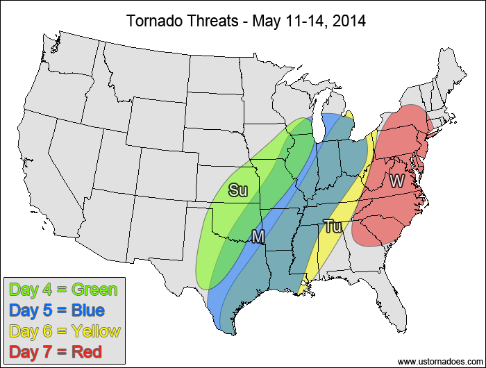
Central and southern Plains, western Midwest — TORNADO RANGE: 2-8 — CONFIDENCE: Low
Expected Tornado Hotspot: Mid-Mississippi Valley
Pros: Good speed shear, decent/good directional shear in the northern areas, moderate to high instability, decent/good upper-level forcing
Cons: Storms could line out quickly, cold front could undercut storms, poor/okay directional shear in the southern areas
Monday
Southern Plains, mid-southern Mississippi Valley, Midwest — TORNADO RANGE: 1-4 — CONFIDENCE: Low
Expected Tornado Hotspot: None
Pros: Decent/good speed shear, good forcing, low to moderate instability
Cons: Poor/okay directional shear, unidirectional flow aloft, mostly linear storm mode
Tuesday
ArkLaTex, Midwest, Tennessee Valley — TORNADO RANGE: 1-4 — CONFIDENCE: Low
Expected Tornado Hotspot: None
Pros: Good forcing, low to moderate instability
Cons: Poor/okay directional shear, okay speed shear, unidirectional flow aloft, mostly linear storm mode
Wednesday
Mid-Atlantic, Carolinas — TORNADO RANGE: 0-3 — CONFIDENCE: Low
Expected Tornado Hotspot: None
Pros: Good forcing, low to moderate instability
Cons: Poor/okay directional shear, okay speed shear, unidirectional flow aloft, mostly linear storm mode
{ "@context": "https://schema.org", "@type": "Article", "mainEntityOfPage": { "@type": "WebPage", "@id": "https://ustornadoes.com/2026/07/30/claiming-mega-wins-free-spins-deals-for-uk-players/" }, "headline": "Claiming Mega…
Getting Started with Daytonaspin: A Guide for UK Players For players in the United Kingdom…
{ "@context": "https://schema.org", "@type": "Article", "mainEntityOfPage": { "@type": "WebPage", "@id": "https://ustornadoes.com/2026/07/30/pink-lady-casino-registration-in-the-united-kingdom-guide/" }, "headline": "Pink Lady…
Understanding Your Payment Options at Extreme Spins Navigating the financial landscape of an online casino…
Understanding the MySpins Welcome Bonus in the United Kingdom For players in the United Kingdom,…
It's peak tornado season. We briefly examine the top outbreaks from April-June.