Programming Note: Thursday’s forecast will likely be an abridged version (no pros/cons listed) and will be the last forecast for at least a couple of weeks. Ian, myself and JT (same crew as last year) will be heading out to the Plains this Friday. Like last year, I plan on making daily posts here cataloging our chases and whatever other things we may end up doing on down days.
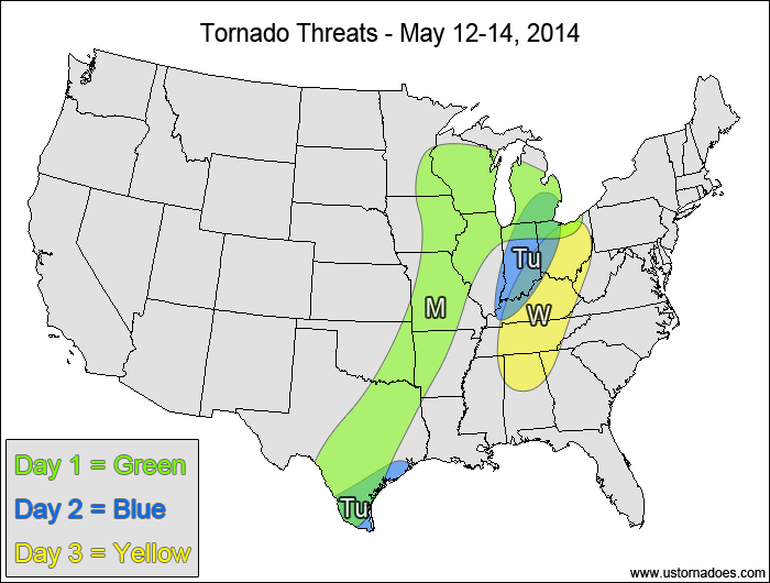
Southern Plains, Midwest — TORNADO RANGE: 1-5 — CONFIDENCE: Normal
Expected Tornado Hotspot: Western Midwest
Pros: Good speed and directional shear in the western Midwest along with low to moderate instability
Cons: Extensive cloud cover in the areas with the more favored dynamics, weaker wind shear and weaker forcing in the eastern and southern parts of the risk area
Tuesday
Eastern Midwest — TORNADO RANGE: 0-2 — CONFIDENCE: High
Expected Tornado Hotspot: None
Pros: Decent speed shear, low to moderate instability
Cons: Poor directional shear, ongoing clouds and showers limiting instability, upper-level vort. max lifting northward out of the U.S.
Southern Texas — TORNADO RANGE: 0-2 — CONFIDENCE: High
Expected Tornado Hotspot: None
Pros: Good directional shear, low to moderate instability
Cons: Fairly weak speed shear, cold front and storms in before peak afternoon heating, somewhat linear storm mode
Wednesday
Ohio and Tennessee Valleys — TORNADO RANGE: 2-6 — CONFIDENCE: Normal
Expected Tornado Hotspot: None
Pros: Weak surface low development allows surface winds to become more backed, decent speed shear, good upper-level dynamics, low to moderate instability
Cons: Weak directional shear aloft, clouds and showers could inhibit instability, directional shear in the southern areas is questionable
Location — TORNADO RANGE: 1-5 — CONFIDENCE: Normal
Expected Tornado Hotspot: None
Pros: Decent/good directional and speed shear, decent/good upper-level forcing
Cons: Low instability, warm sector cloud cover, weak lapse rates
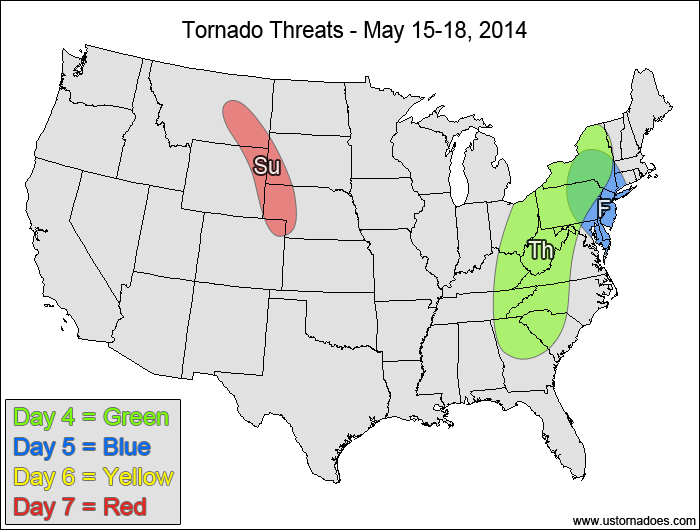
Friday
Mid-Atlantic, western New England — TORNADO RANGE: 0-2 — CONFIDENCE: Normal
Expected Tornado Hotspot: None
Pros: Good speed shear, decent/good low-level directional shear good/strong upper-level forcing
Cons: Low instability, backing winds in the upper-levels, mostly linear storm mode
Saturday
No tornadic activity expected.
Sunday
Northwestern Plains — TORNADO RANGE: 0-3 — CONFIDENCE: Normal
Expected Tornado Hotspot: None
Pros: Good/strong directional shear, decent/good speed shear, low to moderate instability, decent upper-level forcing
Cons: Limited moisture, high LCLs, questionable storm coverage
{ "@context": "https://schema.org", "@type": "Article", "mainEntityOfPage": { "@type": "WebPage", "@id": "https://ustornadoes.com/2026/07/30/claiming-mega-wins-free-spins-deals-for-uk-players/" }, "headline": "Claiming Mega…
Getting Started with Daytonaspin: A Guide for UK Players For players in the United Kingdom…
{ "@context": "https://schema.org", "@type": "Article", "mainEntityOfPage": { "@type": "WebPage", "@id": "https://ustornadoes.com/2026/07/30/pink-lady-casino-registration-in-the-united-kingdom-guide/" }, "headline": "Pink Lady…
Understanding Your Payment Options at Extreme Spins Navigating the financial landscape of an online casino…
Understanding the MySpins Welcome Bonus in the United Kingdom For players in the United Kingdom,…
It's peak tornado season. We briefly examine the top outbreaks from April-June.