Programming Note: Thursday’s forecast will likely be an abridged version (no pros/cons listed) and will be the last forecast for at least a couple of weeks. Ian, myself and JT (same crew as last year) will be heading out to the Plains this Friday. Like last year, I plan on making daily posts here cataloging our chases and whatever other things we may end up doing on down days.
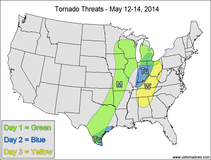
Southern Plains, Midwest — TORNADO RANGE: 1-5 — CONFIDENCE: Normal
Expected Tornado Hotspot: Western Midwest
Pros: Good speed and directional shear in the western Midwest along with low to moderate instability
Cons: Extensive cloud cover in the areas with the more favored dynamics, weaker wind shear and weaker forcing in the eastern and southern parts of the risk area
Tuesday
Eastern Midwest — TORNADO RANGE: 0-2 — CONFIDENCE: High
Expected Tornado Hotspot: None
Pros: Decent speed shear, low to moderate instability
Cons: Poor directional shear, ongoing clouds and showers limiting instability, upper-level vort. max lifting northward out of the U.S.
Southern Texas — TORNADO RANGE: 0-2 — CONFIDENCE: High
Expected Tornado Hotspot: None
Pros: Good directional shear, low to moderate instability
Cons: Fairly weak speed shear, cold front and storms in before peak afternoon heating, somewhat linear storm mode
Wednesday
Ohio and Tennessee Valleys — TORNADO RANGE: 2-6 — CONFIDENCE: Normal
Expected Tornado Hotspot: None
Pros: Weak surface low development allows surface winds to become more backed, decent speed shear, good upper-level dynamics, low to moderate instability
Cons: Weak directional shear aloft, clouds and showers could inhibit instability, directional shear in the southern areas is questionable
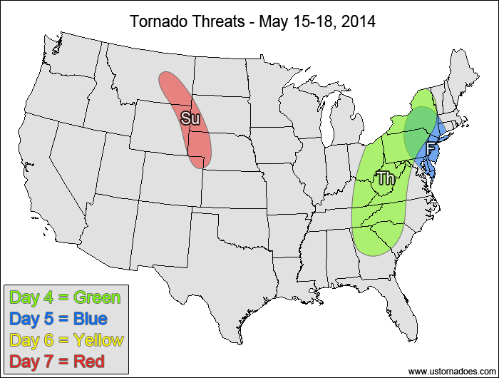
Location — TORNADO RANGE: 1-5 — CONFIDENCE: Normal
Expected Tornado Hotspot: None
Pros: Decent/good directional and speed shear, decent/good upper-level forcing
Cons: Low instability, warm sector cloud cover, weak lapse rates
Friday
Mid-Atlantic, western New England — TORNADO RANGE: 0-2 — CONFIDENCE: Normal
Expected Tornado Hotspot: None
Pros: Good speed shear, decent/good low-level directional shear good/strong upper-level forcing
Cons: Low instability, backing winds in the upper-levels, mostly linear storm mode
Saturday
No tornadic activity expected.
Sunday
Northwestern Plains — TORNADO RANGE: 0-3 — CONFIDENCE: Normal
Expected Tornado Hotspot: None
Pros: Good/strong directional shear, decent/good speed shear, low to moderate instability, decent upper-level forcing
Cons: Limited moisture, high LCLs, questionable storm coverage
Latest posts by Mark Ellinwood (see all)
- Spring 2023 seasonal tornado outlook - March 1, 2023
- Spring 2022 seasonal tornado outlook - March 1, 2022
- Spring 2021 seasonal tornado outlook - March 1, 2021


