Spring is alive with the sights and sounds of tornadoes! There aren’t a lot of them, but the day-to-day numbers will start to add up as we head into the middle of the month.
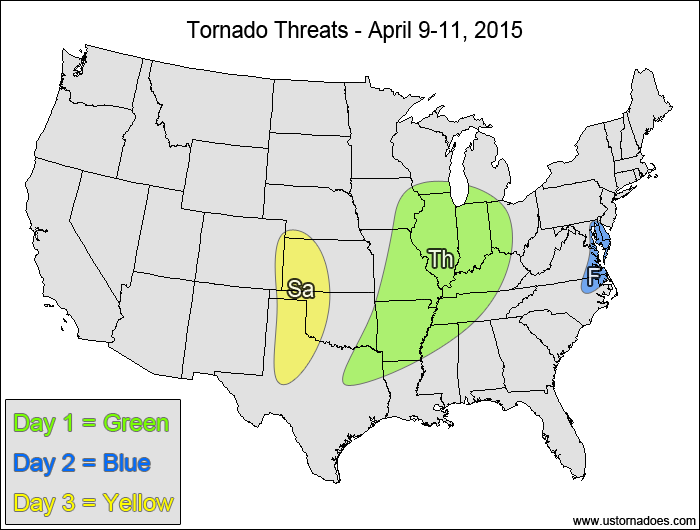
Midwest, central Miss. Valley — TORNADO RANGE: 3-8 — CONFIDENCE: Normal
Expected Tornado Hotspot: West-central Illinois
Pros: Good speed shear, decent low-level directional shear, moderate instability, good upper-level forcing.
Cons: Fairly unidirectional flow aloft, storms lining out along the cold front, pre-frontal cloud cover and showers/storms stabilizing the atmosphere.
Friday
Southeastern Mid-Atlantic, northeastern North Carolina — TORNADO RANGE: 0-1 — CONFIDENCE: High
Expected Tornado Hotspot: None
Pros: Good speed shear, low to moderate instability, possible local enhancement of backing winds at the surface.
Cons: Poor directional shear, storms lining out along the cold front.
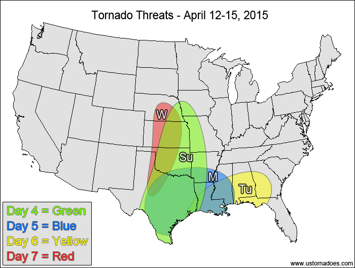
Saturday
Southern and central High Plains — TORNADO RANGE: 0-2 — CONFIDENCE: Normal
Expected Tornado Hotspot: None
Pros: Good directional shear, decent speed shear, low to moderate instability.
Cons: Neutral/rising heights, , uncertainty in storm coverage, possible capping and/or LCL issues.
Central and southern Plains, Miss. Valley — TORNADO RANGE: 2-6 — CONFIDENCE: Low
Expected Tornado Hotspot: None
Pros: Decent/good speed and directional shear, low to moderate instability, decent upper-level forcing.
Cons: Earlier clouds and showers/storms could limit instability, uncertainty in the storm modes, best dynamics don’t line up well with best instability.
Monday
Southeastern Plains, southern Miss. Valley — TORNADO RANGE: 1-4 — CONFIDENCE: Low
Expected Tornado Hotspot: Southeastern Plains
Pros: Decent/good directional shear, low to moderate instability, some upper-level forcing over Texas.
Cons: Cloud cover and earlier storms working over the atmosphere, somewhat weak speed shear, uncertainty in the storm modes.
Tuesday
Deep South — TORNADO RANGE: 0-2 — CONFIDENCE: Low
Expected Tornado Hotspot: None
Pros: Low to moderate instability, areas of decent low-level shear near a warm front.
Cons: Somewhat weak speed shear, weak directional shear in most of the warm sector, weak upper-level dynamics, cloud cover and earlier storms working over the atmosphere.
Wednesday
Central and southern Plains — TORNADO RANGE: 0-3 — CONFIDENCE: Low
Expected Tornado Hotspot: None
Pros: Decent/good upper-level dynamics, good directional shear, decent speed shear.
Cons: Questionable instability and storm coverage, best dynamics separated from best instability.
{ "@context": "https://schema.org", "@type": "Article", "mainEntityOfPage": { "@type": "WebPage", "@id": "https://ustornadoes.com/2026/07/30/claiming-mega-wins-free-spins-deals-for-uk-players/" }, "headline": "Claiming Mega…
Getting Started with Daytonaspin: A Guide for UK Players For players in the United Kingdom…
{ "@context": "https://schema.org", "@type": "Article", "mainEntityOfPage": { "@type": "WebPage", "@id": "https://ustornadoes.com/2026/07/30/pink-lady-casino-registration-in-the-united-kingdom-guide/" }, "headline": "Pink Lady…
Understanding Your Payment Options at Extreme Spins Navigating the financial landscape of an online casino…
Understanding the MySpins Welcome Bonus in the United Kingdom For players in the United Kingdom,…
It's peak tornado season. We briefly examine the top outbreaks from April-June.