Another weekend, another potential tornado outbreak in the Plains. Seems to be a weekly thing this spring. Having a near normal April and May tornado count seems foreign compared to the past few years.
So the next forecast on Monday will be the last one for a few weeks. Why? Because I/we are going STORM CHASING WOOOOOOOO! Like previous years, I will be putting up daily posts about our chasing while we are on the road. More details (including how to follow the group’s chases) coming next week.
Western Texas — TORNADO RANGE: 0-3 — CONFIDENCE: Normal
Expected Tornado Hotspot: None
Pros: Moderate instability, good directional shear.
Cons: Little upper-level forcing, fairly weak speed shear, potential issues with high LCLs.
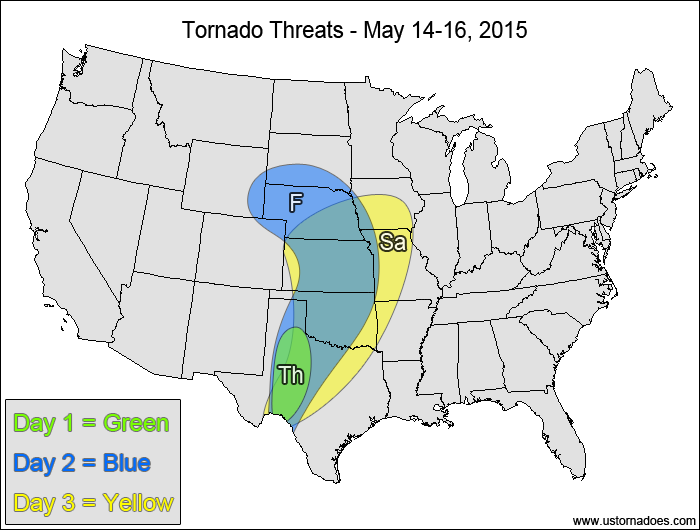
Friday
Plains — TORNADO RANGE: 8-20 — CONFIDENCE: Normal
Expected Tornado Hotspot: Southern South Dakota, Nebraska, northern Kansas
Pros: Good/excellent low-level shear, decent/good speed shear, moderate instability.
Cons: Best upper-level forcing still too far west, potential issues with morning clouds/convection contaminating the atmosphere, mid-level winds could be stronger.
Saturday
Central and southern Plains, southwestern Midwest — TORNADO RANGE: 16-40 — CONFIDENCE: Normal
Expected Tornado Hotspot: Southern Kansas, Oklahoma, northern Texas
Pros: Moderate instability, decent/good directional shear, good speed shear, good upper-level forcing.
Cons: Winds start to back in the mid-to-upper levels in Nebraska and Kansas, potential issues with morning clouds/convection contaminating the atmosphere.
Midwest, Miss. Valley, southeastern Plains — TORNADO RANGE: 8-20 — CONFIDENCE: Normal
Expected Tornado Hotspot: Midwest
Pros: Decent/good speed and directional shear, moderate instability, decent upper-level forcing in the Midwest.
Cons: Morning clouds/convection could contaminate the atmosphere, cold front could case storms to go linear more quickly, very little upper-level forcing in the southern half of the risk area, height falls are fairly weak.
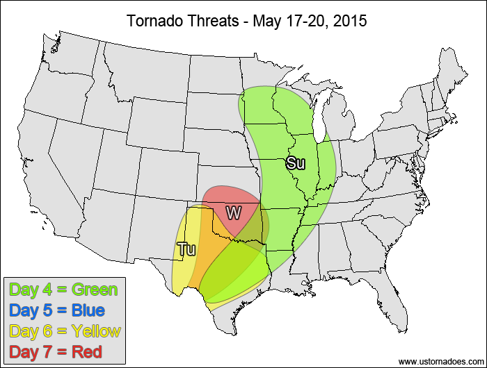
Monday
No tornadoes expected.
Tuesday
Southern Plains— TORNADO RANGE: 1-4 — CONFIDENCE: Low
Expected Tornado Hotspot: Southern High Plains
Pros: Moderate instability, good directional shear, decent speed shear in the High Plains, a little upper-level forcing in the High Plains.
Cons: Potential issues with morning clouds/convection, weak speed shear and little to no upper-level forcing in the eastern areas, neutral/rising heights.
Wednesday
Southern Plains — TORNADO RANGE: 2-7 — CONFIDENCE: Low
Expected Tornado Hotspot: Southern Kansas, Oklahoma
Pros: Good directional shear, decent speed shear in the northern areas, moderate instability, a bit of upper-level dynamics in the northern areas.
Cons: Weak speed shear and little to no upper-level dynamics in the southern areas, potential timing and orientation issues with the upper-level shortwave.
{ "@context": "https://schema.org", "@type": "Article", "mainEntityOfPage": { "@type": "WebPage", "@id": "https://ustornadoes.com/2026/07/30/claiming-mega-wins-free-spins-deals-for-uk-players/" }, "headline": "Claiming Mega…
Getting Started with Daytonaspin: A Guide for UK Players For players in the United Kingdom…
{ "@context": "https://schema.org", "@type": "Article", "mainEntityOfPage": { "@type": "WebPage", "@id": "https://ustornadoes.com/2026/07/30/pink-lady-casino-registration-in-the-united-kingdom-guide/" }, "headline": "Pink Lady…
Understanding Your Payment Options at Extreme Spins Navigating the financial landscape of an online casino…
Understanding the MySpins Welcome Bonus in the United Kingdom For players in the United Kingdom,…
It's peak tornado season. We briefly examine the top outbreaks from April-June.