Another weekend, another potential tornado outbreak in the Plains. Seems to be a weekly thing this spring. Having a near normal April and May tornado count seems foreign compared to the past few years.
So the next forecast on Monday will be the last one for a few weeks. Why? Because I/we are going STORM CHASING WOOOOOOOO! Like previous years, I will be putting up daily posts about our chasing while we are on the road. More details (including how to follow the group’s chases) coming next week.
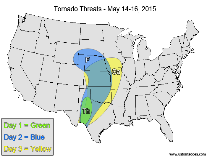
Western Texas — TORNADO RANGE: 0-3 — CONFIDENCE: Normal
Expected Tornado Hotspot: None
Pros: Moderate instability, good directional shear.
Cons: Little upper-level forcing, fairly weak speed shear, potential issues with high LCLs.
Friday
Plains — TORNADO RANGE: 8-20 — CONFIDENCE: Normal
Expected Tornado Hotspot: Southern South Dakota, Nebraska, northern Kansas
Pros: Good/excellent low-level shear, decent/good speed shear, moderate instability.
Cons: Best upper-level forcing still too far west, potential issues with morning clouds/convection contaminating the atmosphere, mid-level winds could be stronger.
Saturday
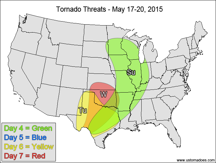
Central and southern Plains, southwestern Midwest — TORNADO RANGE: 16-40 — CONFIDENCE: Normal
Expected Tornado Hotspot: Southern Kansas, Oklahoma, northern Texas
Pros: Moderate instability, decent/good directional shear, good speed shear, good upper-level forcing.
Cons: Winds start to back in the mid-to-upper levels in Nebraska and Kansas, potential issues with morning clouds/convection contaminating the atmosphere.
Midwest, Miss. Valley, southeastern Plains — TORNADO RANGE: 8-20 — CONFIDENCE: Normal
Expected Tornado Hotspot: Midwest
Pros: Decent/good speed and directional shear, moderate instability, decent upper-level forcing in the Midwest.
Cons: Morning clouds/convection could contaminate the atmosphere, cold front could case storms to go linear more quickly, very little upper-level forcing in the southern half of the risk area, height falls are fairly weak.
Monday
No tornadoes expected.
Tuesday
Southern Plains— TORNADO RANGE: 1-4 — CONFIDENCE: Low
Expected Tornado Hotspot: Southern High Plains
Pros: Moderate instability, good directional shear, decent speed shear in the High Plains, a little upper-level forcing in the High Plains.
Cons: Potential issues with morning clouds/convection, weak speed shear and little to no upper-level forcing in the eastern areas, neutral/rising heights.
Wednesday
Southern Plains — TORNADO RANGE: 2-7 — CONFIDENCE: Low
Expected Tornado Hotspot: Southern Kansas, Oklahoma
Pros: Good directional shear, decent speed shear in the northern areas, moderate instability, a bit of upper-level dynamics in the northern areas.
Cons: Weak speed shear and little to no upper-level dynamics in the southern areas, potential timing and orientation issues with the upper-level shortwave.
Latest posts by Mark Ellinwood (see all)
- Spring 2023 seasonal tornado outlook - March 1, 2023
- Spring 2022 seasonal tornado outlook - March 1, 2022
- Spring 2021 seasonal tornado outlook - March 1, 2021


