The most memorable tornado during the week of May 1-7, 2016.
In chaser lingo, days like May 7 are typically thought of as products of “High Plains magic.”
It generally doesn’t take much on the High Plains to create beautiful storms. When the ingredients are right, tornadoes become common as well. In fact, the region east of Denver has the highest density of tornadoes in the country, although they are predominantly weak and often form by non supercellular means.
Thanks to the elevation of the High Plains, plus the natural rising air which aids convection due to upslope flow as that elevation is gained, eastern Colorado is prime grounds for big stuff from little ingredients. Saturday was no different.
#cowx pic.twitter.com/S7sZfk8Fav
— Stas (@StasisChasing) May 7, 2016
[Early May tends to be feast or famine for tornadoes]
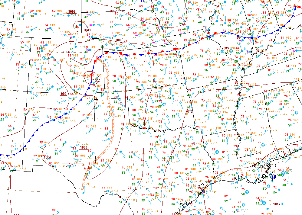
Northeast Colorado found itself near the center of a low pressure system that formed in response to an upper-level trough pushing through the Rockies and toward the Plains.
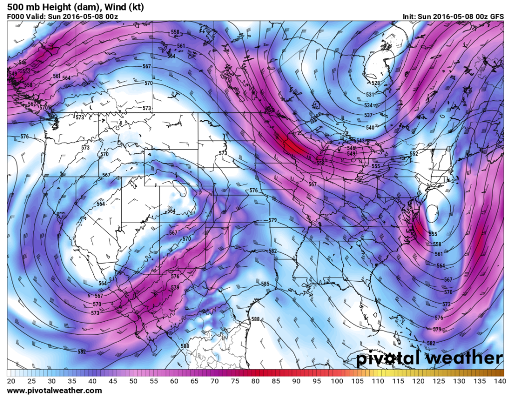
A warm front and dry line were also draped across the region. It was a mild spring day, but not too warm. Not too moist either. The Colorado portion of the warm sector was largely characterized by highs near 70 and dew points in the mid-40s to near 50. In most places, that wouldn’t be cause for much in the way of tornado expectations.
But the ingredients were enough for the High Plains.
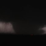
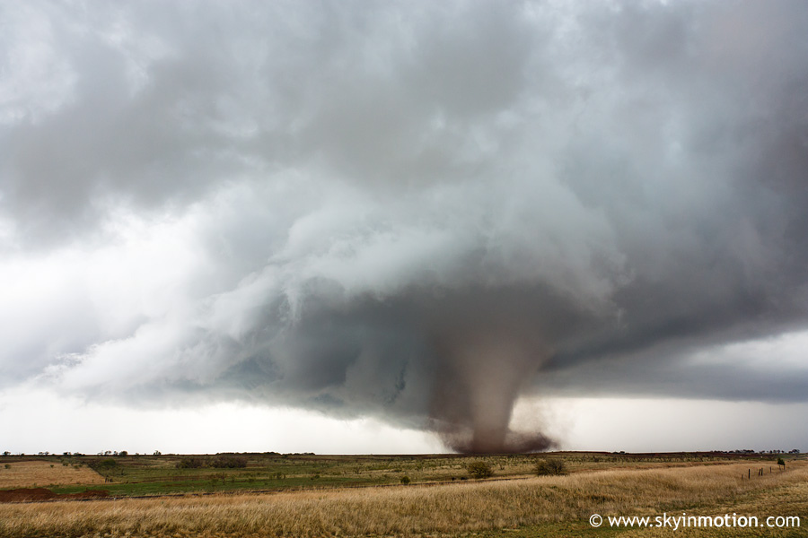
At least five tornadoes — generally tall and CGI-esque — were confirmed across northeast Colorado. Four in NWS Goodland’s area and one in NWS Denver’s. The most visually compelling and most highly photographed of the group was the second that developed near Wray. It was a stunner, and ultimately rated an EF2 or “strong,” the second of the day after one in Weld County earlier during the afternoon. Unfortunately, the Wray EF2 also hit property and caused several injuries.
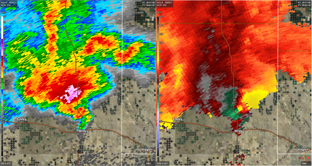
Here’s the radar at the time Wray was near its most photogenic.
And a few more images of the action on Saturday:
Prior to Wray, this tornado formed close by.
GORGEOUS rope #tornado north of Eckley, #CO #cowx @USTornadoes @JimCantore @spann pic.twitter.com/iOoxwIXmBu
— Tornado Trackers (@tornadotrackers) May 7, 2016
Wray was a beauty.
Tornado north of Wray, Colorado. pic.twitter.com/2TjMCrOHZ2
— Sean Schofer (@SeanSchofer) May 8, 2016
https://twitter.com/monsoon_madness/status/729104070598795264
Unbelievable tornado near wray, co!! #cowx pic.twitter.com/daiyJGVz6M
— Mike DeLange (@SeeMikeChase) May 8, 2016
https://twitter.com/ChrisKridler/status/729337542143705088
From further back, more of the storm features like the rear flank downdraft are plainly visible.
https://twitter.com/MrTwisterChaser/status/729199624896925697
#Tornado near Wray, CO this evening. #COWX pic.twitter.com/E0SIhrQDaH
— Ryan Shepard 🌪 (@AStormofPassion) May 8, 2016
Also, check out a 360 video of the storm, or get views from a drone.
‘Tornado of the Week’ replaces the old ‘Tornado Digest.’ It is a way to both identify the most memorable tornadoes during peak season, and a way to take a look at the setup, which will likely often coincide with a larger tornado day. If there are weeks without activity, we may look at a historical tornado from the week. This will run for May and June at least. It will usually be published on Sunday, but may not show up until Monday at times.
This post has been updated to include the tornado’s rating and information on total tornadoes that day.
Latest posts by Ian Livingston (see all)
- Tornado outbreaks: April, May and June peak-season primer - April 27, 2025
- Busy March for twisters to end with another multi-day event - March 28, 2025
- Everything but locusts: NWS shines in apocalyptic weather - March 17, 2025