
After hurricane Isaac made landfall across southern Louisiana late Tuesday August 28 and into early Wednesday, August 29, tornado warnings were seemingly up throughout most of the day that followed. Not a surprise, as tropical systems usually produce tornadoes, particularly those that make landfall across the northern Gulf of Mexico. That was just the beginning.
We’ve been keeping some running tallies going on Twitter, but as tornado verifications roll in, we’ll go ahead and keep track of them here as well. Additionally, I’ve assembled a look at each day of warnings, and some combined stats through the most recent full day of Isaac’s tornado producing life (September 3). As of publish, the system is nearly washed out, though it’s possible additional warnings and/or tornadoes may still come. If that’s the case, those stats will be updated as needed.
Past storms – Warnings/confirmed
Ivan (2004): 213 warnings / 118 tornadoes
Katrina (2005): 167 warnings / 59 tornadoes
Debby (2012): 62 warnings / ~20 tornadoes
There have been 19 tornado watches issued for Isaac: 2 in south Florida on the 26th into 27th, nine along the northern Gulf Coast states from August 28 through August 30, two in the Midwest on August 31, three in the Midwest and South on September 1, two from Kentucky to Mississippi on September 2, and one across parts of Alabama and Mississippi on September 3. Parts of southern Mississippi were under a tornado watch from 9: 45 a.m. Aug 28 through 10 p.m. August 30.
Over the entire period, Hurricane Isaac and its remnants caused 171 tornado warnings. The following National Weather Service offices, by order of the most products, issued warnings: New Orleans, La.; Mobile, Al.; Jackson, Ms.; Paducah, Ky.; Memphis, Tn.; Tallahassee, Fl.; Huntsville, Al.; Central Illinois, Il.; Melbourne, Fl.; St. Louis, Mo.; Louisville, Ky.; Tampa Bay, Fl.; Birmingham, Al.; Little Rock, Ar.; Miami, Fl.; Morristown, Tn.; Nashville, Tn.; Raleigh, NC; and Mount Holly, NJ.
 Mississippi comes in with the most tornado warnings at 77. Alabama, Florida and Missouri all witnessed more than 22. 161 counties have been put under tornado warnings. 15 counties were tornado warned five or more times. The top-5 counties and their warnings were: Jackson County, MS with 12; Hancock County, MS with 11; Harrison County, MS with 11; Wayne County, MS with 11; and Greene County, MS with 9.
As of late September 4, at least 22 tornadoes have been confirmed (see details below). Surveys are still ongoing, and in many cases the information has not yet been posted. Filtered reports to the National Weather Service currently tally 42. Unlike many tornado outbreaks, official tornado reports to NWS are often close to or lower than actual tornadoes. As an an example, Katrina had almost double the tornadoes originally reported by the public or otherwise.
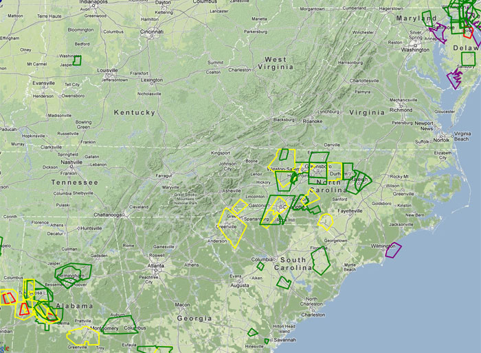
Below are day-by-day maps of select (any encompassed in the tornado warned areas) warnings from Isaac. Red indicates the tornado warnings. Following those maps, we’ll compile confirmations and other items as they come in.
This post will be updated as new information arises.
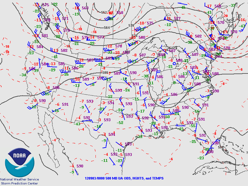
Sunday, August 26 2012 (500mb: 0z, 12z | IEM Local Storm Report App | SPC )
Note: Stats are based off midnight to 11:59 p.m. (local) data. Some measures count 12z-12z as a calendar day.
Tornado warnings: 4
Issuing offices: Miami-South Florida (2), Melbourne (2)
Timing: Late evening into early overnight
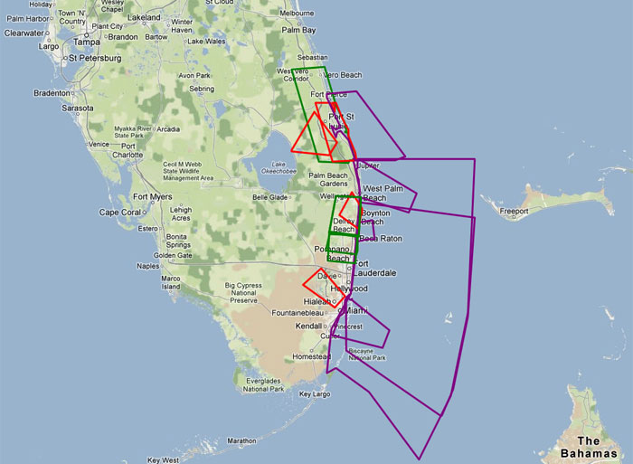
Monday, August 27, 2012 (500mb: 0z, 12z | IEM Local Storm Report App | SPC )
Note: Stats are based off midnight to 11:59 p.m. (local) data. Some measures count 12z-12z as a calendar day.
Tornado warnings: 7
Issuing offices: Melbourne (4), Tampa Bay (3)
Timing: After midnight (Okeechobee), then late day
Tuesday, August 28, 2012 (500mb: 0z, 12z | IEM Local Storm Report App | SPC )
Note: Stats are based off midnight to 11:59 p.m. (local) data. Some measures count 12z-12z as a calendar day.
Tornado warnings: 3
Issuing offices: Mobile (2), New Orleans (1)
Timing: Mid-and-late day

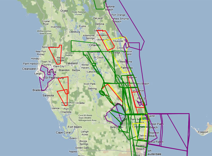
Wednesday, August 29, 2012 (500mb: 0z, 12z | IEM Local Storm Report App | SPC )
Note: Stats are based off midnight to 11:59 p.m. (local) data. Some measures count 12z-12z as a calendar day.
Tornado warnings: 38
Issuing offices: New Orleans (21), Mobile (10), Tallahassee (5), Jackson (2)
Timing: All day and night
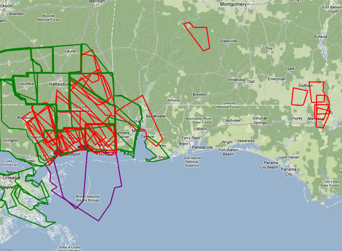
Thursday, August 30, 2012 (500mb: 0z, 12z | IEM Local Storm Report App | SPC )
Note: Stats are based off midnight to 11:59 p.m. (local) data. Some measures count 12z-12z as a calendar day.
Tornado warnings: 56
Issuing offices: Jackson (19), Mobile (18), Tallahassee (9), New Orleans (8), Memphis (2)
Timing: Weighted toward morning, but some all day

Friday, August 31, 2012 (500mb: 0z, 12z | IEM Local Storm Report App | SPC )
Note: Stats are based off midnight to 11:59 p.m. (local) data. Some measures count 12z-12z as a calendar day.
Tornado warnings: 9
Issuing offices: St. Louis (4), Paducah (3), Jackson (1), Little Rock (1)
Timing: Morning and late day
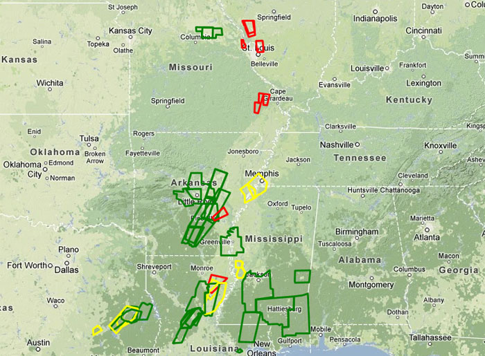
Saturday, September 1, 2012 (500mb: 0z, 12z | IEM Local Storm Report App | SPC )
Note: Stats are based off midnight to 11:59 p.m. (local) data. Some measures count 12z-12z as a calendar day.
Tornado warnings: 33
Issuing offices: Paducah (14), Memphis (8), C Illinois (7), Louisville (2), Little Rock (1), Nashville (1)
Timing: Noon to late evening

Sunday, September 2, 2012 (500mb: 0z, 12z | IEM Local Storm Report App | SPC )
Note: Stats are based off midnight to 11:59 p.m. (local) data. Some measures count 12z-12z as a calendar day.
Tornado warnings: 17
Issuing offices: Huntsville (9), Memphis (5), Louisville (1), Morristown (1), Raleigh (1)
Timing: Afternoon to mid-evening

Monday, September 3, 2012 (500mb: 0z, 12z | IEM Local Storm Report App | SPC )
Note: Stats are based off midnight to 11:59 p.m. (local) data. Some measures count 12z-12z as a calendar day.
Tornado warnings: 4
Issuing offices: Birmingham (2), Jackson (1), Mount Holl1y (1)
Timing: Afternoon / overnight
Surveyed tornadoes… at least 22 (confirmed as of September 4)
Several offices with visually confirmed tornadoes in their areas have not reported yet. Additionally, some tornadoes are still being investigated by offices that have reported. These numbers will grow, perhaps considerably.
This post will be updated as new information arises.
Jackson, Ms. Event Page | Tampa Post Storm Hurricane Report | Tallahassee Post Storm Hurricane Report | Little Rock, Ar. Event Page | Memphis Tornado Reports 9/1 | Central Illinois Storm Report | Mobile Post Hurricane Storm Report |
Alabama – 4
EF-0 (8/29): Monroe County, 2 miles NE of Old Texas
EF-0 (8/29): Greene County, 3 miles SE of Sand Hill
EF-0 (8/30): Choctaw County, 1 mile E of Toxey
EF-1 (8/30): Geneva County, 7 miles northwest of Samson – 3 mile track
(either a continuation of this tornado or a separate EF-0 occurred later near Kinston)
Arkansas – 1
EF-2 (9/1): Clay County, Corning – 2.5 mile track
(another tornado was produced by this storm, either not yet surveyed or counted as one)
Delaware – 1
EF-0 (9/3): Kent County, Camden – 215 yard track
Florida – 4
EF-0 (8/27): Indian River County, 5 miles west of Vero Beach – 1.6 mile track
EF-0 (8/27): Hillsborough County (waterspout moving ashore), 2 miles ESE of Tampa
EF-0 (8/29): Jackson County, 1 mile east of Greenwood
EF-0 (8/29): Holmes County, 2 miles north of Graceville
Illinois – 9
EF-1 (8/31): Morgan County, 0.6 miles south of Franklin – 1/4 mile track
EF-0 (8/31): Morgan County, 3 miles WNW of Franklin
EF-0 (9/1): Woodford County, 2 miles ESE of Benson
EF-0 (9/1): Woodford County, 3 miles north of Benson
EF-0 (9/1): Woodford/Marshall counties, 4 miles NNW of Benson – 1.5 mile track
EF-0 (9/1): Marshall County, Illinois River 1.5 mile SE of Hopewell
EF-0 (9/1): Stark County, 4.5 miles ESE of Wymoing – 1.2 mile track
EF-0 (9/1): Stark/Marshall county line, 4 miles SE of Castleton
EF-0 (9/1): Stark County, 4 miles N of Wyoming
Mississippi – 2
EF-1 (8/30): Clarke County, 2 miles ENE of Crandall – 6.1 mile track
EF-1 (8/30): Lauderdale County, 1 mile ENE of Causeyville – 1.4 mile track
Missouri – 1
EF-0 (9/1): Clarke County, Bucoda – 100 yard track
(two other touchdowns were reported in the area, NWS compiling info)
Isaac tornado videos
Posted: 10:00 a.m. Sept 4 | Last updated: 9:30 p.m. Sept 4
Latest posts by Ian Livingston (see all)
- Tornado outbreaks: April, May and June peak-season primer - April 27, 2025
- Busy March for twisters to end with another multi-day event - March 28, 2025
- Everything but locusts: NWS shines in apocalyptic weather - March 17, 2025