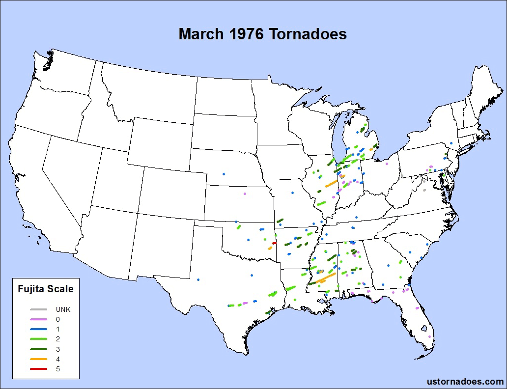
March is the only month with a record number of monthly tornadoes that was set prior to the 1990s which still stands today. It happened in 1976.
180 tornadoes touched down on 17 days during the month, and that’s 225 percent the current normal of 80 tornadoes.
Related: The Perfect Tornado Year | March tornado climatology | Strong March tornadoes
Significant tornado events occurred on four occasions: March 12, March 20-21, March 26-27 and March 29-30.
Strong tornadoes were much more frequent on average compared to overall climatological levels, with 47 percent of them rated F2 or stronger. Eight violent tornadoes touched down, including one F5 in Oklahoma.
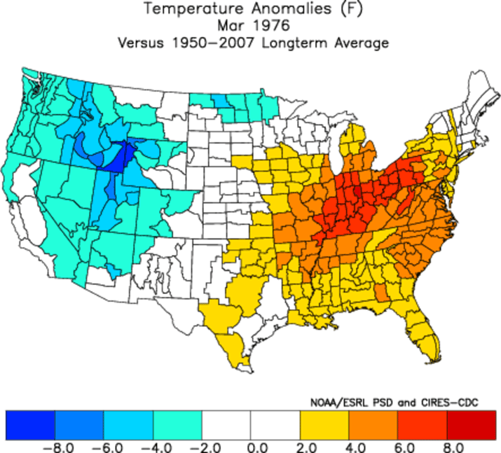
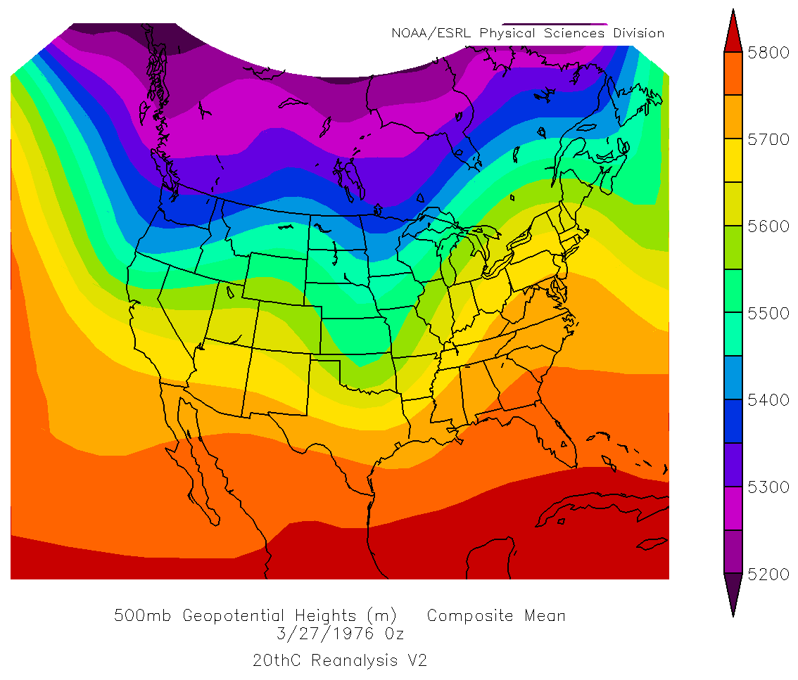
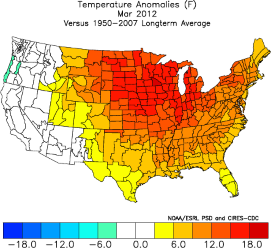
Like March of 2012 (also a top 5 tornado producer for March), the month was characterized by quite warm temperatures across parts of the country. The spatial coverage of the anomalies and the temperatures themselves were not on par, but it was still unusually mild for the month, at least east of the continental divide. Instead of focusing most of its tornado fury early in the month, March 1976 brought its worst in the final two thirds.
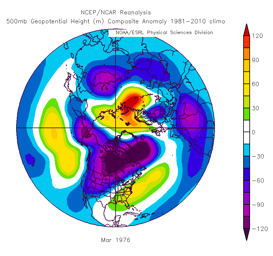
Even on a full-month scale, and in combination with the temperature anomaly image above, it is easy to see a general East Coast and Southeast ridge in firm control, along with troughing over the western and west-central United States. The mid and upper level ridging off the east coast would efficiently pour moisture and heat into the country, with the troughing acting as a trigger for storms.
The first week of the month was characterized by an upper trough pushing east across the country in a fast flow, and capped by a cutoff in the southwest late week. The second low ejected out into a pretty marginal environment, but still dropped a handful of tornadoes on its way east.
Another upper-low dropped into northern California at the beginning of week 2. The northern jet stream flow remained quite fast, fairly common coming out of a La Nina winter. But at the same time, the California upper low continued digging, reaching southern California by the morning of the 10th.
By the 11th, the mid and upper level trough pushed out toward the Four Corners as a high pressure glided off the Southeast coast. Moisture return across the Gulf Coast and Mid South was workable as a surface low developed coming off the central Rockies.
The morning of the tornado outbreak on the 12th featured a sub-1000 mb surface low climbing through Iowa. A warm front draped through Illinois, Indiana and off the Southeast Coast. As the low moved northeast on a path that would take it across southern Wisconsin and then northern lower Michigan, so did the front and small warm sector.
Despite relatively modest surface moisture — Chicago and Springfield IL briefly made dew points in the 50s — numerous tornadoes touched down from near Chicago and southeast into Indiana during the midday and early afternoon. Tornadoes then continued to dot the landscape up into Michigan through the late afternoon.
An additional batch of tornadoes occurred in the South across Alabama from late afternoon into the overnight of the 12th.
March 12, 1976 (27 tornadoes): F0, 2; F1, 9; F2, 10; F3, 6
By the 14th, the low responsible for the outbreak was a distant memory for the country as another high dropped through the Southeast. A strong and mostly stationary low southwest of Greenland helped ensure the pattern would stay fast and active, and a growing upper level ridge near the Southeast was really taking hold.
With minimal moisture return in front of it, a low pushed off the southern High Plains and through the Midwest during the 15th. It ultimately reached better conditions for tornadoes on the 16th, dropping 9 from southern Alabama up into South Carolina, several of which were strong.
Following that weaker system, which partially acted to draw moisture north without fully shunting it out afterward, a large surface high pressure drifted across the South. It ultimately parked off the Southeast coast by the 19th and 20th.
At the same time, a strong 500 mb disturbance was passing through the northwest U.S. and out into the Plains. It sparked a powerful surface low that traveled near the U.S./Canada border.
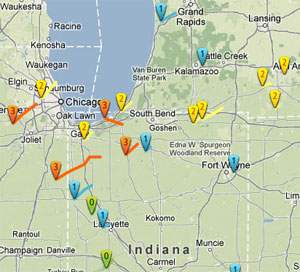
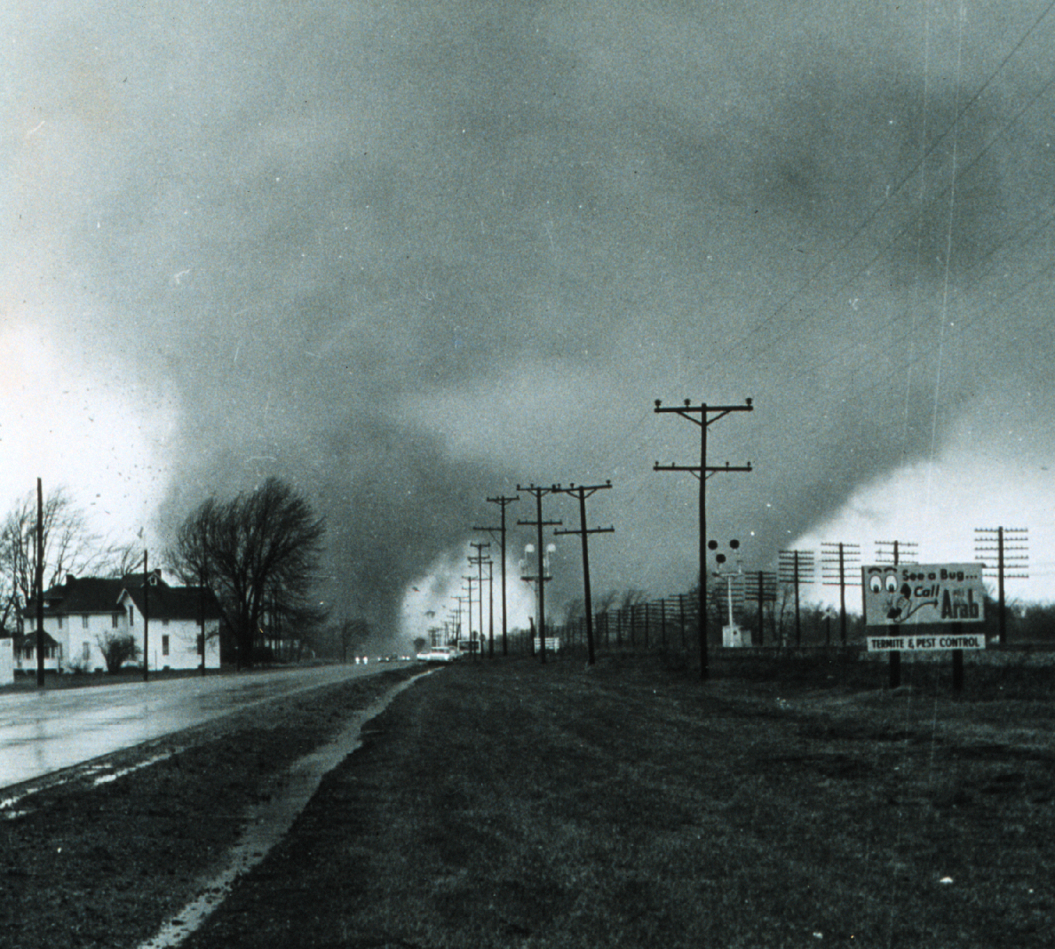
One of the tornadoes on March 20, 1976. This one was rated F4.
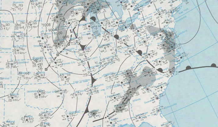
On the morning of the 20th, an expansive warm sector was located across the Midwest as a 984mb surface low churned near International Falls, MN. A cold front extended through Wisconsin, down into central Missouri and then back into north-central Texas. The stage was set for the largest tornado outbreak of the month.
Temperatures and dew points were on the order of 10-15 degrees higher across the region impacted compared to the outbreak on the 12th (70/60+ up into Illinois and 65/55+ into the Detroit area). Three F4s dropped; one each in Illinois, Indiana and Michigan. An expansive southern area of the outbreak occurred as well, centered on Mississippi and Alabama.
With no breaks of six hours or more, this outbreak continued into the 21st, when tornadoes touched down across the Mid-Atlantic starting late morning on the 21st. 14 additional tornadoes occurred in this area centered on Pennsylvania, bringing the outbreak total to 66.
March 20-21, 1976 (66 tornadoes): F?, 3 | F0, 14 | F1, 22 | F2, 17 | F3, 7 | F4, 3
The barrage of storm systems continued into the beginning of the last week of March 1976, though the first in the next series passed by without much surface moisture to tap. By the 26th and 27th, the ingredients were once again around for a sizeable string of tornadoes.
On the morning of the 26th, a surface low pressure that originated east of Denver was moving through Iowa, while secondary low pressure was forming near the Oklahoma/Kansas border.
Ample moisture was streaming into the region out ahead of this low. The third large outbreak of the month was about to occur.
By early in the afternoon of March 26, tornadoes were beginning to drop, with number two and three of the outbreak attaining violent tornado status in eastern Oklahoma. Both of those tornadoes were killer tornadoes, with the second hitting Spiro as an F5.
Additional tornadoes pushed across Arkansas and parts of Missouri through the early evening, before tornadoes touched down in Mississippi during the overnight.
March 26-27, 1976 (19 tornadoes): F1, 8 | F2, 4 | F3, 4 | F4, 2 | F5, 1
With the way March 1976 went through that point, it was probably not a surprise that as the system dropping the F5 was exiting east, another disturbance was dropping through the West Coast. The upper trough continued to dig into the end of the month, finally ejecting out beginning on March 29.
Depending on how stringent you are on a definition no one has cared to truly define, this may either be two outbreaks or one. There are two gaps in touchdowns of seven hours, though for this post it can be taken as one event without much issue.
On the morning of March 29 a low pressure system was located near where Colorado, Kansas and Oklahoma meet. A warm front was pushing north near the Red River of Texas.
The first batch of tornadoes with this final outbreak of the month spread from Arkansas through Mississippi and into Alabama, most storms formed near that warm front. Two F4s were noted in Mississippi.
Additional activity developed ahead of the cold front pushing into the early hours of the 30th. This area of tornado activity was focused from eastern Texas back into Mississippi. Interestingly an F3 that formed northeast of Natchez had an end point right near where an F4 started the day prior.
And, unusual as it might be to get tornadoes up into Michigan so early, the low pressure system that was in the southern Plains developed and headed northeast through Wisconsin and into Canada.
This helped bring another volley of tornadoes to the state, when five (including two F3s) touched down in mainly forested areas of the north.
March 29-30, 1976 (33 tornadoes): F0, 4 | F1, 10 | F2, 12 | F3, 5 | F4, 2
23 states witnessed tornadoes during March 1976, with Alabama leading the way at 25. Indiana (21), Mississippi (21), Michigan (17), Texas (14), Illinois (12), Arkansas (10) and Florida (10) round out the list of those with ten or more tornadoes.
There were 21 fatalities caused by 13 killer tornadoes. One tornado, an F3 which dropped just north of Little Rock, Arkansas on the 29th, killed 5 people as the deadliest for the month. 739 were injured in total during the month. The longest tornado path was 126 miles through south-central Mississippi on the 29th.
Additional sources…
NOAA Central Library U.S. Daily Weather Maps Project http://docs.lib.noaa.gov/rescue/dwm/data_rescue_daily_weather_maps.html
Earth System Research Laboratory, US Climate Division Dataset Mapping Page, http://www.esrl.noaa.gov/psd/data/usclimdivs/
Earth System Research Laboratory, Daily Mean Composites, http://www.esrl.noaa.gov/psd/data/composites/day/
Tornado History Project, http://www.tornadohistoryproject.com
Latest posts by Ian Livingston (see all)
- Tornado outbreaks: April, May and June peak-season primer - April 27, 2025
- Busy March for twisters to end with another multi-day event - March 28, 2025
- Everything but locusts: NWS shines in apocalyptic weather - March 17, 2025