On May 22, 2011 the city of Joplin, Missouri was impacted by an EF-5 tornado. There were 158 deaths with over a thousand injured as a result of the tornado.
At its peak it was up to a mile wide with winds in excess of 200 miles per hour. The tornado was on the ground for 22.1 miles and lasted an estimated 38 minutes from start to finish. Around 7,000 homes were destroyed, not including any businesses or public buildings.
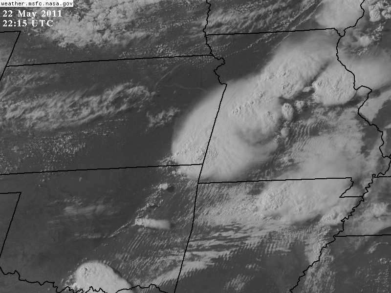
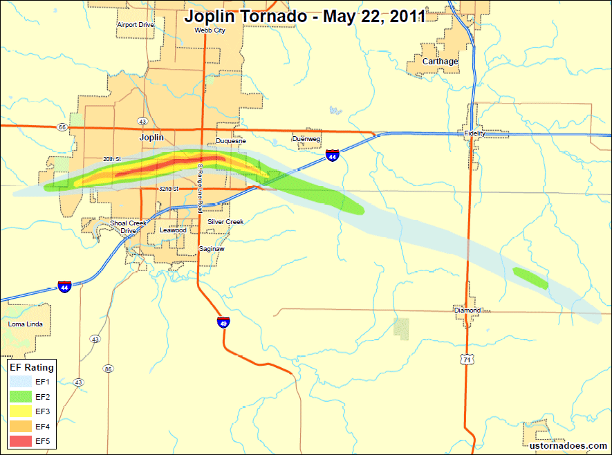
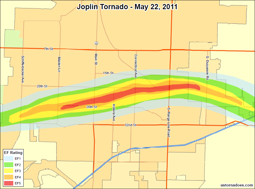
The tornado touched down about a half mile southwest of JJ Highway and West 32nd Street, where storm spotters and chasers reported seeing multiple vortices around the main circulation prior to the tornado becoming rain wrapped.
From the approximate starting point, the tornado traveled towards South Alfalfa Street, where EF-1 damage was found. The tornado then moved east along 32nd Street, where low EF-2 damage to well-constructed brick and wooded frame homes was observed near South Country Club Drive. At this point, the tornado was about one quarter mile in width.
Continuing east northeast, the tornado crossed 32nd Street where it produced EF-2 to low EF-3 damage from Iron Gate Road east to Schifferdecker Avenue. Low EF-4 damage was found just west of Schifferdecker Avenue as smaller well-built commercial buildings sustained heavy damage.
After crossing Schifferdecker Avenue, the tornado moved east toward McClelland Boulevard with a forward speed of 20 to 25 miles per hour. It was over three quarters of a mile wide.
St. John’s Hospital was severely damaged — 200 to 300 pound parking stops were lifted and tossed 30 to 60 yards. Large steel reinforced concrete steps outside of a medical art building were shifted a few inches and cracked. Concrete walls toppled and steel support beams from some buildings were curved and twisted. EF-3 to low end EF-5 damage continued to just east of Rangeline Road as the tornado approached the Dusquesne area.
At full strength, the tornado crushed homes and swept them from their foundations. Steel reinforced concrete porches and driveways were lifted and tossed. Vehicles were tossed into other homes or in some cases rolled up and crushed completely. This type of damage was found the along the rest of the track to just east of Rangeline Road. Along the track, boards, limbs and twigs were embedded into wood and stucco walls and wooded framed homes were completely disintegrated. Franklin Technical Center was destroyed as was the newer section of Joplin High School; the outer walls of the older section were severely damaged. A bank was completely destroyed, except for the concrete bank vault.
At South Rangeline Road and 20th Street EF-4 and low end EF-5 damage was also found, where several well-constructed buildings were destroyed. A parking lot west of a Home Depot and a portion of the Walmart parking lot had scoured asphalt. Vehicles were tossed, one into the Home Depot. Once the tornado crossed Rangeline Road, it began to weaken. EF-3 and low EF-4 damage was found as the tornado was roughly half a mile wide. The tornado moved southeast as it crossed Interstate 44; damage here was EF-2 — cars and trucks were blown off the interstate. The tornado lifted about 4.8 miles north northeast from Granby, Missouri.
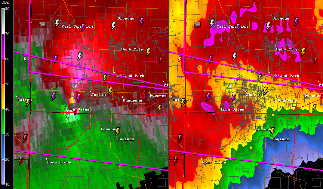
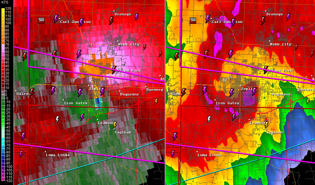
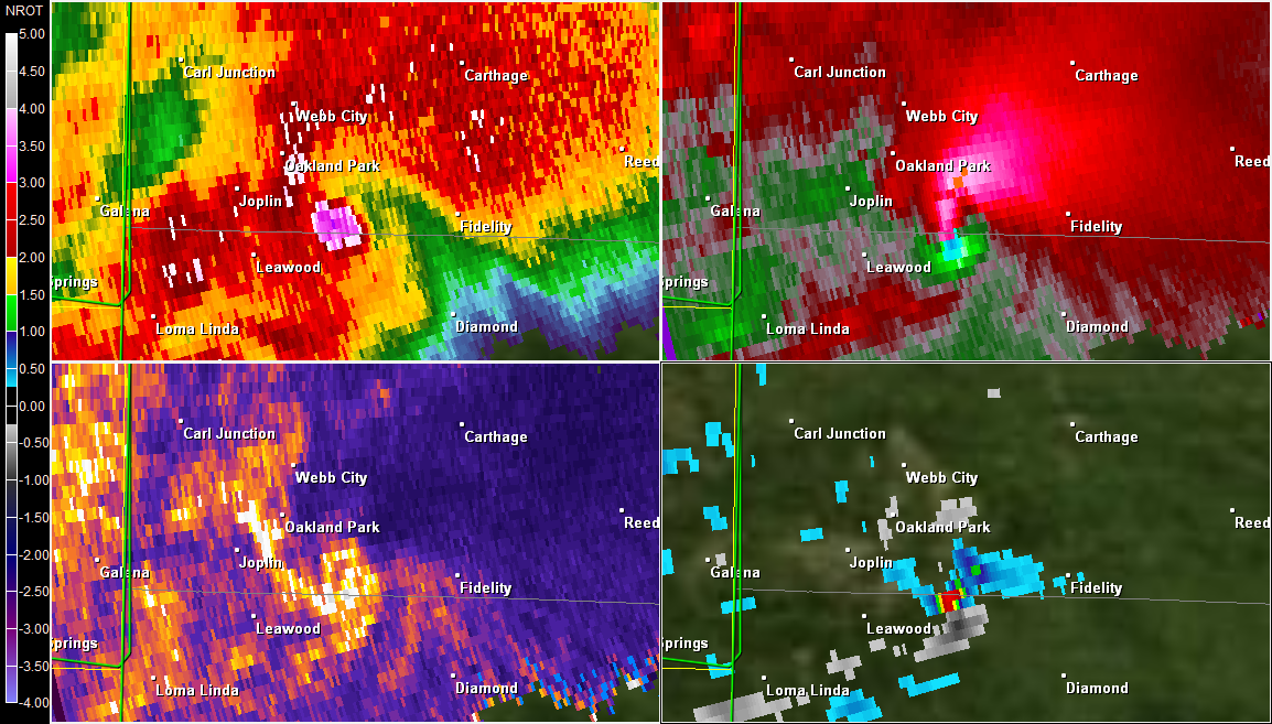
The maps below show the track of the tornado as it touched down and moved through the city of Joplin and depict the approximate swath of damage as surveyed by the National Weather Service Springfield Weather Office.
An interactive map with survey descriptions and first hand videos as the tornado occurred can be found below or in a full-size version here.
Map views best in Firefox or Chrome.
A complete detailed survey report of the Joplin tornado can be found here: http://www.crh.noaa.gov/sgf/?n=event_2011may22_survey
A special thanks to my husband Jason Wheatley for his help with the interactive map. I would also like to thank JoMo, a member of American Weather forums and a resident of Joplin, who compiled the list of videos and the locations at which they were taken that are showcased on the interactive map.
Data source: NWS Springfield, MO office and ESRI
Katie Wheatley
Latest posts by Katie Wheatley (see all)
- March 29-31, 2022 tornado outbreak - April 3, 2022
- March 25, 2021 tornado outbreak - March 25, 2021
- May 3-4, 1999 tornado outbreak and the Bridge Creek-Moore F5 - May 3, 2019

that was sad
The Joplin tornado is the most deadliest tornado I have heard of. The tornado went from an ef-1 tornado to an ef-5 tornado in ten to thirty minutes. Have you heard of the 7 tornados in Grand Island, Nebraska? I am fifth grader in Grand Island Nebraska. – MK
Well if you say that was dangerous in 2005 on the gulf coast where hurricane Katrina formed, created about 100 to about 315 tornadoes in total along Mississippi, Louisiana, and Texas.
I’m a 7th grader in San Antonio Texas
this was really helpful thanks web site
thank you for helping!!!