Tornado highlights covering the week of April 12-18, and a brief look ahead.
April continues to do what April does, deliver numerous severe thunderstorms to the country.
The week ending April 18 featured tornado reports on all but two days. Still, no day during the week is likely to be long-remembered when it comes to twisters. By and large, the story there was “quick and weak” when it comes to touchdowns.
A big and slow-moving cut off low was the primary driver of severe weather. It’s finally rejoining the flow as we start this week off. A corresponding severe weather risk pushes toward the East Coast with it. More episodes of storms are likely this week, with caveats.
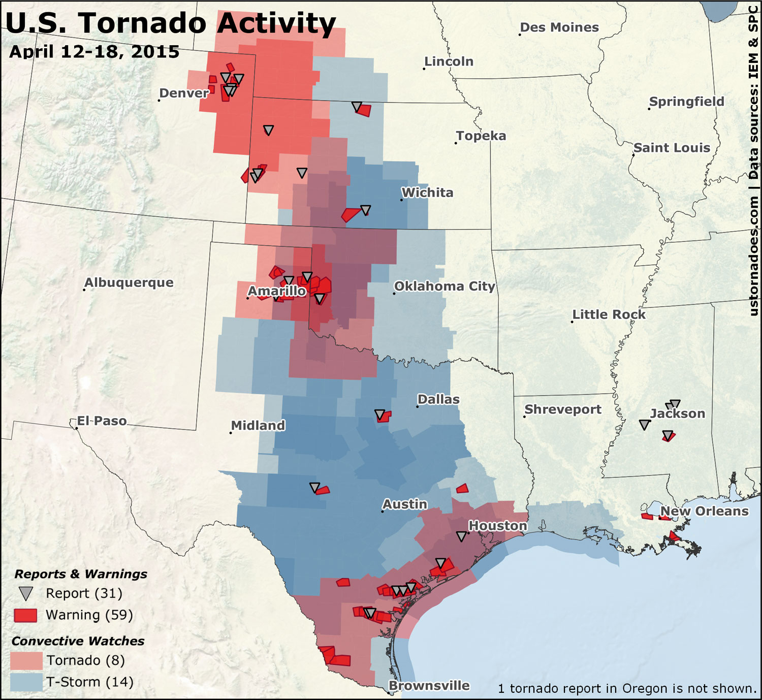
22 convective watches were issued during the week, of which eight were tornado watches. Almost all of these watches came in the Thursday through Saturday time frame as the cut off low slowly ejected into the Plains. The 59 tornado warnings and 31 filtered tornado reports were down from last week.
Related: Tornado Digest archives
April 12: Kansas
This wasn’t a particularly big severe weather day, but two tornado reports came in across Kansas among scattered storms throughout the southern and central Plains.
April 13: Mississippi
Three weak tornadoes touched down across Mississippi after dark.
April 14: Oregon
A brief rain-wrapped tornado was reported at Lane Community College during the afternoon.
April 16: Texas and the Southern Plains
The big and lumbering upper level low pressure system finally began to push out into the Plains. A dryline draped across the Texas and Oklahoma panhandles was a primary conduit for tornadic storms, with others forming in southern Texas as well as western Kansas.
Pano of #tornado warned #storm north of Pampa, #Texas right now. #txwx pic.twitter.com/rHvPkUJ9bE
— Jason Cooley (@operation_chase) April 16, 2015
https://twitter.com/NikolaiStophel/status/589241254195503104
The majority of the tornado reports were from the Texas panhandle into western Oklahoma. At least six tornadoes touched down in the Amarillo NWS warning area alone, all EF0 (the weakest on the scale).
Below is a video taken near Sayre, OK later in the evening.
April 16th 2015 Tornado from Zac Flamig on Vimeo.
At least two tornadoes were confirmed in western Oklahoma, as well as a few in Kansas and southern Texas. The next video below was taken in western Kansas near the Colorado border.
https://www.youtube.com/watch?v=ZHJD3kqMJ0Q
April 17: High Plains and South Texas
It was another day with a lot of storms, many of which were “messy” if you’re looking for a notable tornado event. An additional handful of tornado reports came in from the High Plains and across southern Texas.
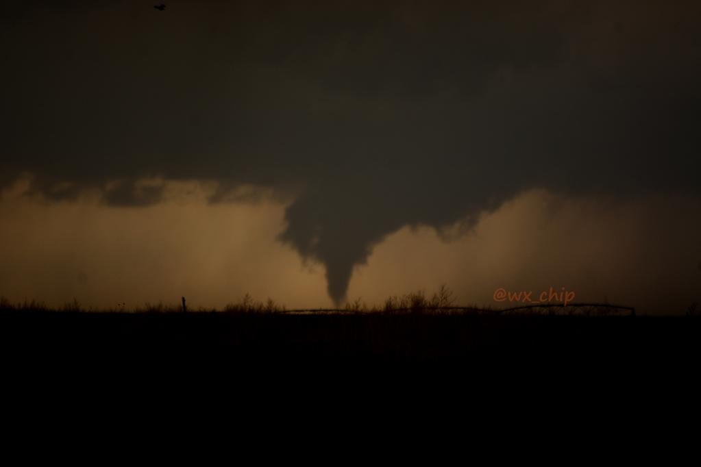
A quick-hitting “needle in the haystack” was among the most photogenic of the day, and it occurred southeast of Goodland, Kansas.
First shot of the tornado tonight southeast of Goodland, KS! She purdy! #kswx pic.twitter.com/6l4l3SbKkJ
— Chip Redmond (@wx_chip) April 18, 2015
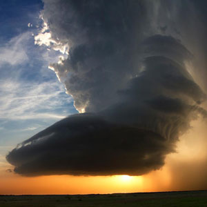
Plenty of pretty storms across the Plains, even without many tornadoes.
Brief (1 minute) funnel cloud just northwest of Ness City just now. #kswx pic.twitter.com/VmE1OVCFMC
— Grady Dixon (@pgradydixon) April 18, 2015
Got a decent shot of the wall cloud wrapping up from yesterday's Merino, CO tornado warned storm. #COwx pic.twitter.com/zJy14CzCqp
— Ryan Hickman (@ryanhickman) April 18, 2015
Southern Texas found itself under the gun for a second evening in a row, with Refugio unluckily catching tornado warnings both days.
Tornado Warning now in effect for extreme southcentral Goliad, NW Refugio, & E Bee county until 8:00PM! Take shelter! pic.twitter.com/AvHOlMWQvU
— NWS Corpus Christi (@NWSCorpus) April 18, 2015
April 18: High Plains and Southern Plains
Cut offs are tricky. No day looked particularly great in this string for a big tornado outbreak, but several looked iffy, then filled with more potential, then iffy. Saturday, April 18, was one of those days.
Tough to tell if this funnel touched (maybe pic 1?) the ground…would like to see it touch b4 calling tornado #cowx pic.twitter.com/CnGdY0HBcL
— Brian Bledsoe (@BrianBledsoe) April 18, 2015
Holy smokes!! Well organized supercell underway near Snyder, #Oklahoma. #okwx #storm pic.twitter.com/eSY9F3Ayie
— Jason Cooley (@operation_chase) April 18, 2015
High-based wall cloud w/rising scud on this bizarre, formerly tornado warned storm near Mason, TX @KXAN_Weather #txwx pic.twitter.com/8D9BwSoKOJ
— Tornado Trackers (@tornadotrackers) April 18, 2015
Tornado watches were hoisted in the central High Plains and western Oklahoma/eastern Texas. For the most part, neither watch area produced much in the way of tornadoes. A bit of a veer-back-veer profile as well as “too many” thunderstorms generally helped keep the atmosphere on the less conducive (for tornado) side. Meager moisture also a culprit in spots.
Now and later
Best odds of severe through Monday, and again by mid-to-late week
As this big cutoff low finally starts to fall apart and mesh back into the moving pattern, today has already proven to be a busy one for severe weather, including a number of tornado watches, warnings, and reports. It seems a good bet that continues, to some degree, tomorrow along the East Coast.
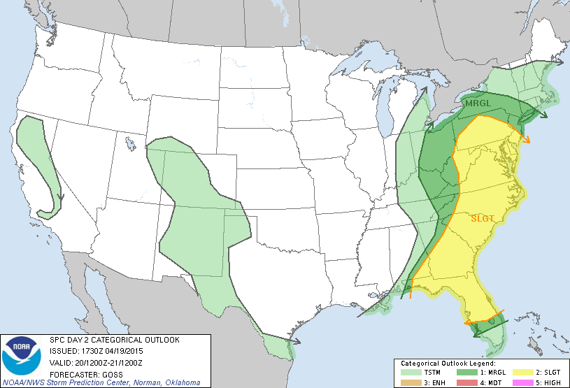
The next series of disturbances along the active southern jet stream begin to impact the country pretty quickly on the heels of this one. SPC has already outlooked Tuesday in parts of Texas and Oklahoma, and Wednesday in the Southern Plains and Mid-South.
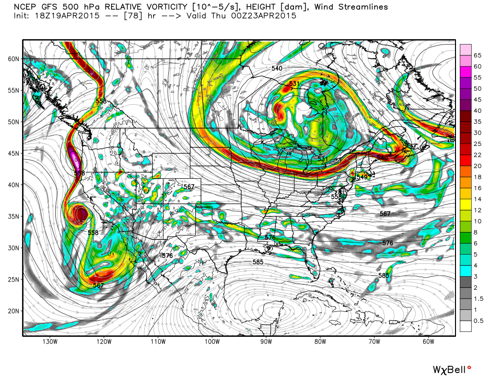
Given a large-scale pattern with a northeast U.S./southeast Canada trough through much of the week, it’s likely there will be some “issues” for getting anything significant to occur tornadowise. Especially this early in the season, it’s going to tend to favor a cool season feel rather than a warm season one.
By the latter part of the work week and into the weekend, it appears a more appreciable upper level low will try to push out, but perhaps in a similar manner to what was just seen. Background eastern troughing — which might begin to lift by then — may continue to play a role in keeping moisture return limited.
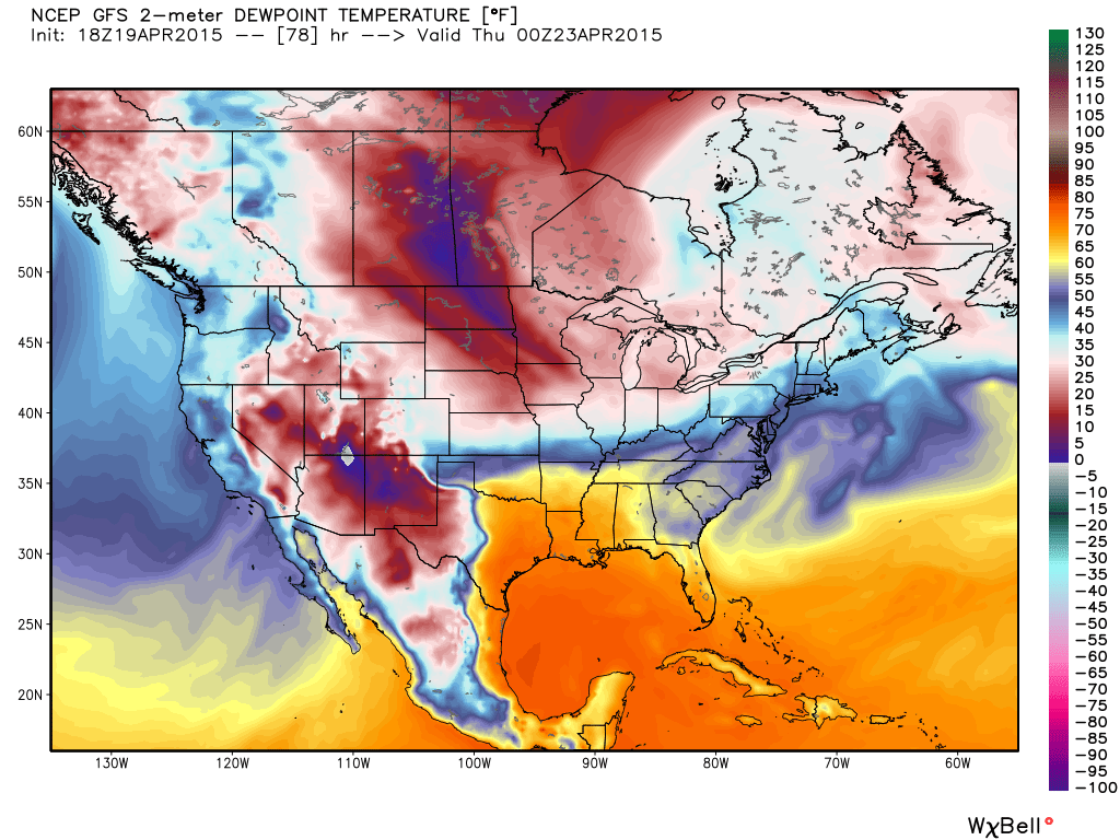
While no major tornado episodes are apparent at this point, it does appear relatively active when it comes to disturbances. And that can always cause some problems this time of year.
Latest posts by Ian Livingston (see all)
- Top tornado videos of 2023 - January 1, 2024
- March 31, 2023 tornado outbreak videos - March 31, 2023
- Top tornado videos of 2022 - December 31, 2022
Thank you for the excellent report!! Greatly appreciate the website and articles.