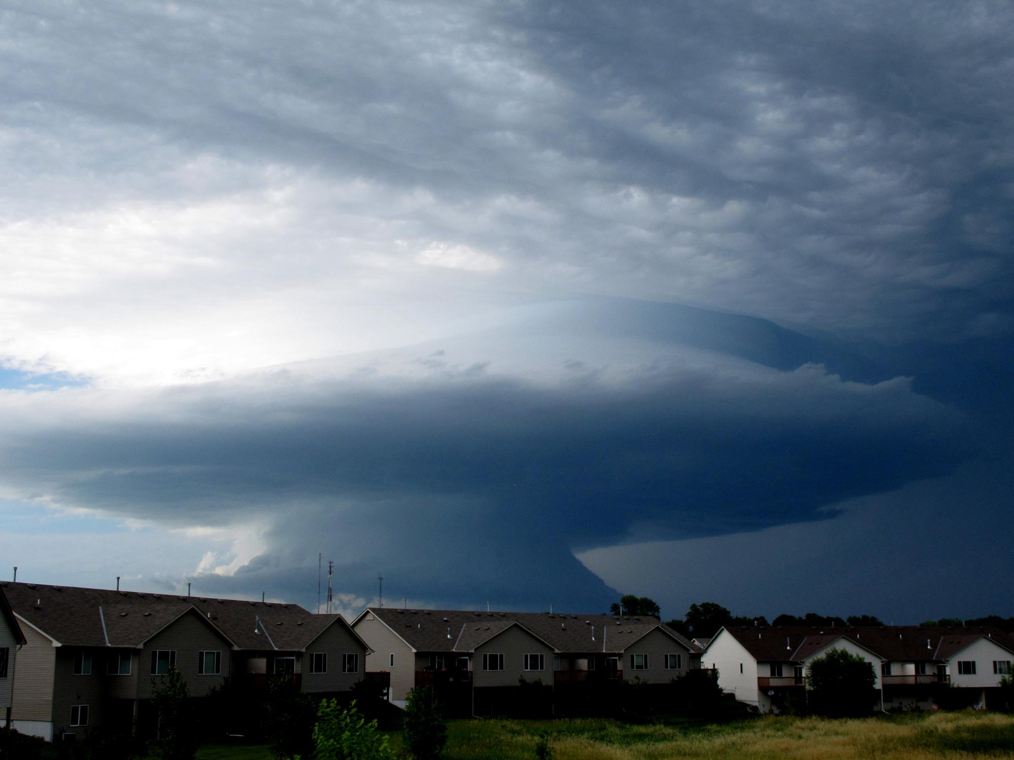
As we head into the heart of the 2016 tornado season, this year has already been both big and small. A behemoth of a winter outbreak took place in February, but March has been rather quiet (although it may end on a busier note). Given that we’re coming out of one of the strongest El Ninos on record, now seems as good of a time as any to at least briefly delve into the relationship between El Nino Southern Oscillation (ENSO) and tornado activity across the country.
ENSO has two main active phases: El Nino which is characterized by warming of the equatorial Pacific, and La Nina which is characterized by cooling of the same region. Both changes from normal tend to significantly alter weather patterns. When it comes to El Nino and La Nina’s impact on tornadoes, the literature is quite mixed and with various areas of focus. Some studies have found at least minor differences based on ENSO phase, others not much at all.
This post is unlikely to add anything major to the debate, but it will hopefully help contextualize some potential takeaways while keeping things rather simple and general.
Ideas that emerge which appear to hold some weight include a front-loading to tornado season coming out of La Nina, and a back-loading in El Nino. The southeast United States appears to be a moderate-to-strong La Nina tornado magnet. Places like California, and at least parts of the northern tier may favor the year following a moderate-to-strong El Nino. And regardless of the ENSO phase, disastrous tornado episodes are intermixed throughout.
Disclaimer and background
There are various definitions of ENSO phases. There’s even some disagreement among experts on which is which and/or what fits into where. For the purposes of the weather scribblings here, I am using winter phases based on the Oceanic Nino Index (ONI). From there, it’s a simple rolling forward through the whole year that followed.
Keep in mind that any sort of comparison using the full record is going to be extra problematic when it comes to tornado counts. I haven’t done any fancy calculations to attempt to fix those here.
Population and observation capabilities have increased since 1950 when the modern record began, in some cases quite dramatically. This has given rise to an “inflated” sense of higher tornado counts, a trend which has begun to stabilize in recent decades but it may not necessarily be done artificially rising just yet. A vast majority of the increase has been in the weakest tornadoes (mostly F/EF0 but also F/EF1). Think about all the 30 second swirls chasers catch that weren’t seen in the 1960s.
Nonetheless, I’m going to use the whole record in most of the below because it’s a small sample to begin with. Fortunately, ENSO phase changes are fairly common. Since 1950, there have been 23 El Ninos, 20 La Ninas, and 23 instances with neither (Neutral or La Nada). El Ninos have a bit of the short end of the stick thanks to a bunch early in the record.
In all cases below, except for the general tornado fatality figures, I have grouped moderate and strong El Ninos or La Ninas together. Other categories contain weak levels of each, as well as years with neither El Nino or La Nina (AKA La Nada or neutral).
Is there any impact on timing?
“Tornado season” is of course something of a misnomer. Tornadoes happen all year most years. That said, over half of the tornadoes on record have come in a three month span from April-June. That percentage rises to about 75 percent looking at March through July. So tornado season is only something of a misnomer.
There’s a reason we think of tornadoes in the heart of spring and into the early summer before intense heat takes over as the big story. ENSO phase doesn’t really change a whole lot when it comes to that idea, but there might be a few clues in the limited data we have.
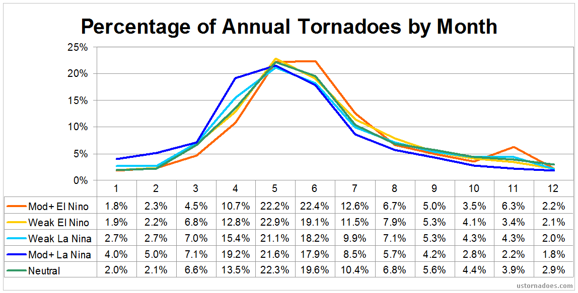 It’s notable that May is the favored month for peak tornadoes coming out of all types of ENSO, except in moderate to strong El Ninos. In this phase, May and June are basically identical over the years, but June holds a very slight — two tenths of a percent — edge. I won’t make too much of that in itself as we could easily revert back to May this year!
Rounding error type issue aside, it is a shift off “normal,” which features a peak in May and April averaging fewer tornadoes than June. Above it is easy to see that post El Nino years tend to start slower but hold on a bit longer than other years.
Moderate to strong La Ninas have placed on April and early-season compared to normal. Over 19 percent of moderate or strong La Nina tornadoes have occurred in April compared to the non-Nina average of 12 percent. The moderate and strong La Ninas have a higher percentage of tornadoes than other phases from January through April in the sample, then fall behind the rest in May and stay there through the year. Weaker La Ninas exhibit similarities of their stronger siblings in an active early season, but to a much smaller degree.
And just briefly, I’ll kind of be watching that November bump as we get later into this year. That’s “second season” time, but it’s kind of interesting it shows mainly post-Nino here. The rollover likely loses impact once we get into the back half of the year, but there are typical transitions from El Ninos like we may see in 2016. I’m talking years that flipped from a moderate or strong El Nino to a La Nina, like 1988 and 1973, both of which featured very active Novembers. At the same time, 1998 was quite quiet.
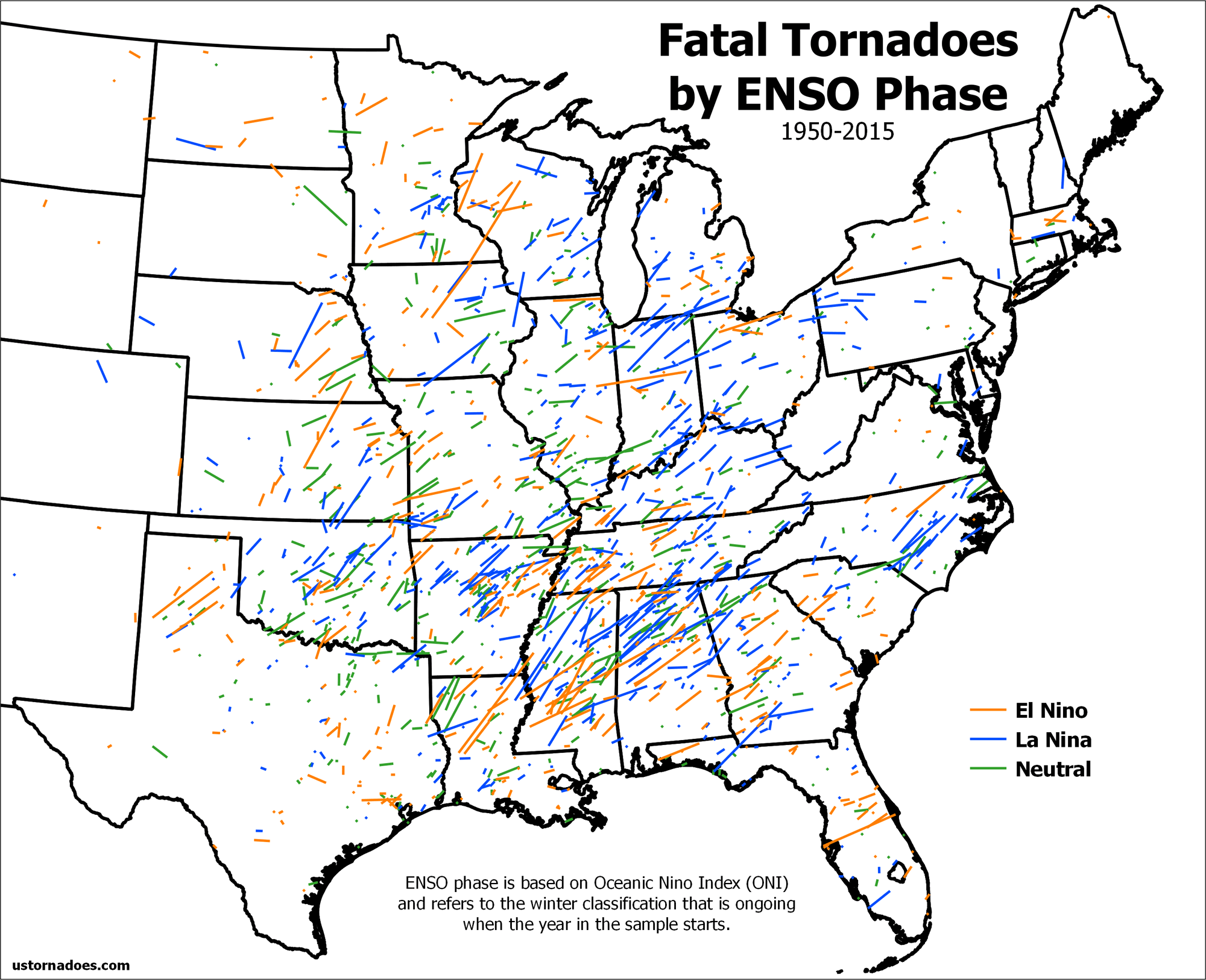
How it looks across the CONUS
There’s certainly a lag in the atmosphere coming out of an ENSO phase. It lasts at least into the middle of the year and probably longer depending on strength and other factors. So the question arises: are there favored areas for tornadoes following a La Nina, an El Nino, or a neutral?
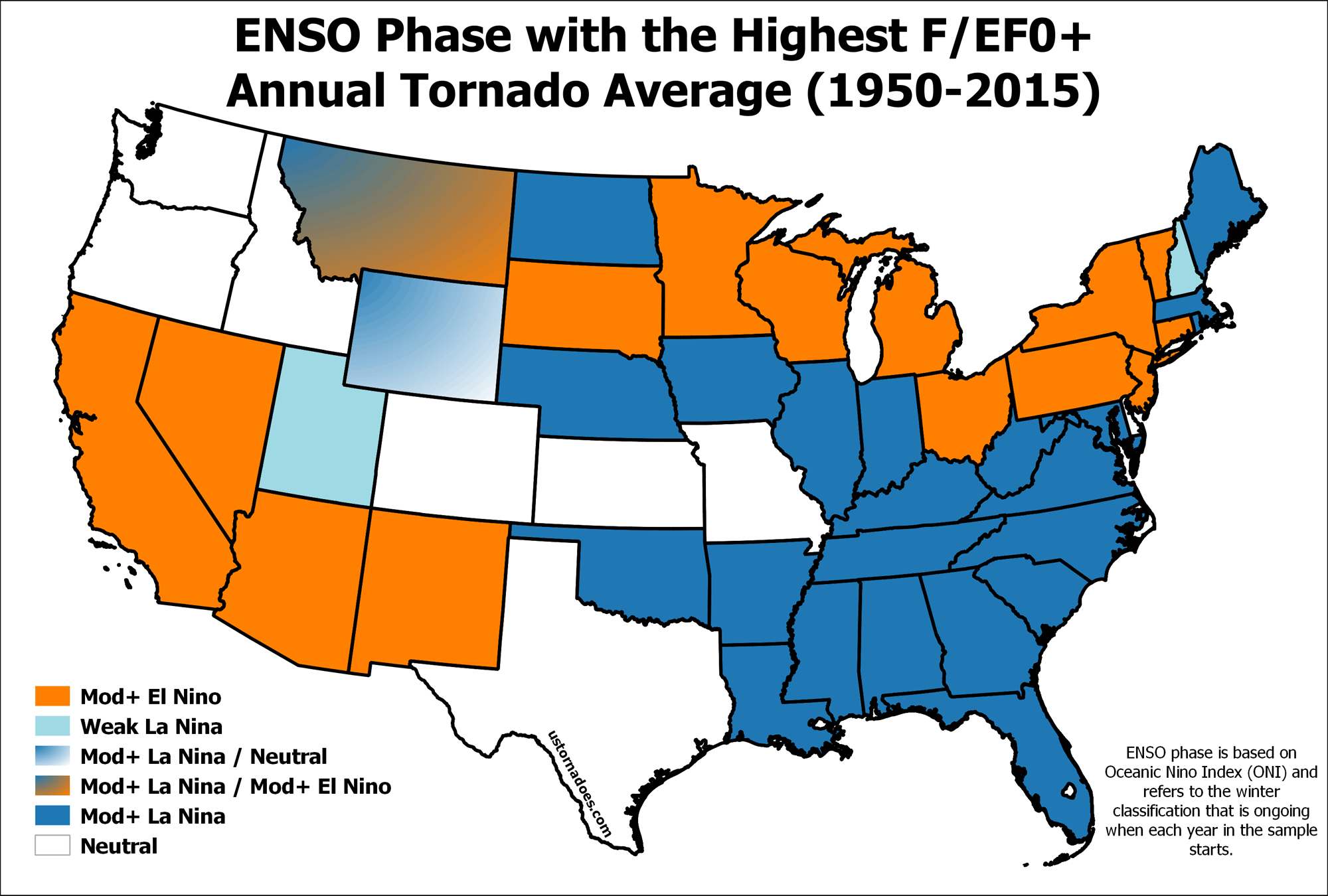
Starting with the whole record back to 1950 delivers some potential leads. Once breaking down by state and by ENSO phase (again it’s the whole year after winter peak shown here), we find moderate and strong La Ninas leading the way when it comes to highest annual tornado average across a good chunk of the country.
Moderate and strong El Ninos took up their fair share of real estate as well, especially up north and out west.
Neutral was the third most likely to be favored. The weak El Ninos and La Ninas were generally barely noticed comparatively. Interestingly, a number of the Plains states tended to favor years coming out of neutral winter when it comes to upside tornado risk.
 If the first sample wasn’t small enough for your liking, I ran data from only 1973 onward, and focused only on F/EF1+. But wait, there’s a reason!
1973 was a good cutoff because it captured the Super Outbreak of 1974 and also the year of 1973 which followed a strong El Nino winter. This is also around the time higher standards for F2 tornadoes were captured in surveying. Focusing on F/EF1+ helps to minimize the inflation of annual numbers that is largely comprised of low-end tornadoes for reasons noted above.
In this way of looking at the country and what ENSO phase tornadoes like best, there’s an even clearer moderate/strong La Nina and then also moderate/strong El Nino focus. Maybe an argument not to sleep on a moderate to strong El Nino despite some studies indicating quieter years coming out of an El Nino.
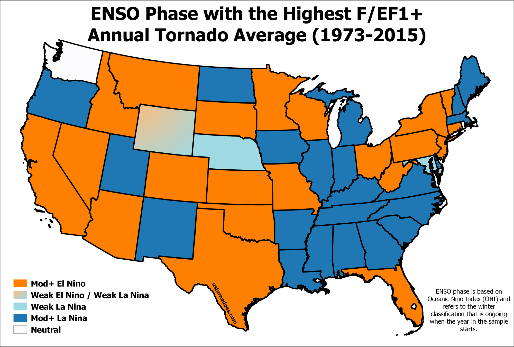 A few ideas transcend both graphics and they are seemingly worth an extra note given repeating patterns. (again, considering these samples are very small from a statistical standpoint, just look how much winter 15-16 followed the “rules”)
16 states have moderate to strong La Ninas as their favored ENSO phase in both periods of record. 12 states have moderate to strong El Ninos favored in both. In general, the southwestern U.S. and northern tier of the country tend to favor the heftier El Ninos for their bigger tornado number years. The Southeast, possibly not including Florida which often sees significant activity in winter during a strong El Nino, is a moderate to strong La Nina zone in both maps as well.
Post La Ninas often deadly … But El Ninos have been rough, too
2011 will keep post-La Nina springs on the minds of current generations until the next hard-to-fathom tornado year comes along. 1974, also post-Nina, did that for generations prior. There are big El Nino years on the books as well when it comes to tornado impact.
Before 2011, 1953 was the leader for tornado deaths in a year during the modern tornado record since 1950.
Even with its way under-reported tornado count — only 421 total! — 1953 was a year coming off a weak El Nino that had huge impact. 523 people were killed. It was an unusual year in that several monster one-tornado disasters occurred: Waco, Flint, and Worcester were the worst of the worst. At a still horrific level came Vicksburg, and five other tornadoes that killed more than ten.
 Per-year averages during the modern record of tornadoes and ENSO (1950 in both cases) favors La Nina with 127 deaths per year, followed by El Nino with 86 per and then neutral with 57.
Given that the average deaths per year has continually fallen across the record, it’s possible that these numbers are somewhat inflated by early years. Then again, 2011 reminds us that we are not immune to the big tallies. In some ways we might even expect more of them in the future as our population centers expand.
In the end, death and injury potential is largely based on luck or bad luck. Shift a Joplin a few miles and no one talks about it today. La Nina’s seeming favoring of some of the densest big tornado country in the United States across the Southeast has a fair amount to do with its higher tallies, but even a quiet year can have an EF-5 roll into a city and cause devastation the likes of nightmares.
Years breakdown
These years are the ones that come after the usual wintertime peak of ENSO conditions.
Strong El Nino: 1958, 1966, 1973, 1983, 1998, 2016 (not included)
Moderate El Nino: 1964, 1987, 1988, 1992, 2003, 2010
Weak El Nino: 1952, 1953, 1954, 1959, 1969, 1970, 1977, 1978, 1980, 1995, 2005, 2007
Strong La Nina: 1974, 1976, 1989
Moderate La Nina: 1956, 1971, 1999, 2000, 2008, 2011
Weak La Nina: 1951, 1955, 1965, 1968, 1972, 1975, 1984, 1985, 1996, 2001, 2012
Neutral: 1950, 1957, 1960, 1961, 1962, 1963, 1967, 1979, 1981, 1986, 1990, 1991, 1993, 1994, 1997, 2002, 2004, 2006, 2009, 2013, 2014, 2015
Latest posts by Ian Livingston (see all)
- Tornado outbreaks: April, May and June peak-season primer - April 27, 2025
- Busy March for twisters to end with another multi-day event - March 28, 2025
- Everything but locusts: NWS shines in apocalyptic weather - March 17, 2025
Graph or map of tornado numbers each year?
All years or just Nino/Nina sample? Could cook that up at some point.
Thank you for your research and efforts! Per the OP, I would be interested in counts by state against the nino/nina analysis as well